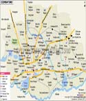
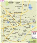
Karaikudi is a city located in the Sivaganga district of
Tamil Nadu. Located on the Trichy-Rameswaram Highway, Karaikudi was earlier a small village in the Ramanathapuram district and in 1928 it was changed from a village to a municipality. The city is home to the Chettair community, who originally were an important part of the salt trade- though in the 18th century they became more famous as financers and facilitators for trade across different commodities. By the early 19th century finance had become the domain of the Chettair community and they had become famous money lenders and owned many acres of land. During the 19th and early 20th century many Chettairs had migrated to Sri Lanka and South Asian countries like Singapore, Malaysia, Vietnam and Burma.
Karaikudi is a well known city also because of the type of houses built there using limestone which is called "Karai Veedu" and also because of a plant called "Karai" which grows profusely in the region. The topography of Karaikudi is primarily flat with a few rocky areas. The River Thennar flows through the south of Karaikudi and the soil of the area is hard red lateritic and is not suitable for cultivation.
Karaikudi Tourist Places
:
- Ariyakudi Kovil - Hindu Temple
- Pranmalai Seik Oliyulla Darga- Muslim Dargah
- Gandhi Square at Maharnonbu Pottal- A place where famous people have delivered speeches
- Aayiram jannal veedu- A large house with 1000 windows
- Vairavan Kovil- Hindu Temple
Karaikudi is very well connected by train and bus and the nearest airport is at Trichy.
Last Updated on : May 11, 2026