
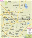
The city houses many places of interests that are not only popular but also attract tourists. Yercaud is a hill resort in the city that was once surrounded by Kadu forest. It is also considered as the least expensive hill station in the country. Lady's Seat is a natural rock structure that gives a panoramic view to the visitors. There are many pilgrim sites too in the city that have their own religious significance. Some of such sites are Kottai Mariamman Temple, Baneshwar Temple, Skandasramam, Kottai Perumal Temple, Siddhar Kovil, Lechler Memorial Church and Jama Masjid.
The city is famous for handlooms, especially silk and cotton production. It is one of the main textile centres in the state and comprises more than 125 spinning mills and garment manufacturing and weaving units. Recently, the Government of India has recognised it as a Textile Export Zone. There is a unit of the Steel Authority of India Limited (SAIL) in the region - Salem Steel Plant, which is involved in the production of stainless steel and carbon steel. This area is also rich in mineral ores with one of the largest deposits of bauxite and magnesite in India. Salem is home to many renowned companies like Nandhi Dall Mills, which one of the oldest flour mill companies; Narasus Coffee, which is a famous type of coffee in Tamil Nadu; and BSP Refineries to name a few. The city is heading towards development as Electronics Corporation of Tamil Nadu Limited (ELCOT) and the Government of Tamil Nadu are planning to build an IT park in the city. On the other hand, SAIL is also planning to make a Steel Special Economic Zone (SEZ) inside Salem Steel Plant.
It is a national centre for starch and sago products and a market town for agricultural products. Leigh Bazaar is the biggest regional market in Salem for the sale purchase of agro products. The market was established in 1840 and still runs in the Salem district. The Shevapet, which is the Dalal Street of Salem, is the commercial hub of the city as it deals with everything, such as gold, silver, oils, food grains, minerals, textiles and many others.
How to Reach?
NH-7, NH 47 and NH 68 are important National Highways that pass through the city. State Highways such as SH 168 and SH 18 also pass through the city and connect it to other cities. Bus services ply between Salem and some other neighbouring cities. Salem Junction connects it to other cities via railway network. There is Salem Airport located in Salem-Bengaluru Highway but is non-operational. Otherwise, the nearest airports to the city are Coimbatore, Tiruchirapalli and Bengaluru.
WBST310315
WBVDA
Last Updated on : May 11, 2026
| Find Distance from Salem to other Indian Cities | |||