|
||||||||||
| ||||||||||
|





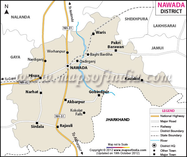
| *Nawada District Map highlights the National Highways, Major Roads, District Headquarter, etc. |
About
Found in southern Bihar, this region belongs to the Magadh Division, covering close to 2,494 square kilometres. To the north lies Nalanda; bordering the east are Sheikhpura along with Jamui. Westward stretches Gaya, while to the south meet Koderma and Giridih - both within Jharkhand. Though small in size, its location links multiple administrative zones across two states.
A split runs through the district, shaped by the course of the Khuri River. On one side lies history - the left bank, home to the town's earlier layout. In contrast, development clusters on the right, where government functions now stand. Facilities such as classrooms, medical aid points, administrative buildings, and a detention center mark this newer zone.
Across most areas, flat ground dominates - except toward the south, where stony zones appear near Jharkhand's elevated stretch. Flowing waterways cross the area without permanence, their broad, sandy, low-depth channels aiding farming only when rain is present.
History and Culture
Deep roots tie this area to old Magadha times. It is said King Brihadratha began the empire on these lands, followed much later by rule under Mauryan, Gupta, and Kanva lines. Traces of long habitation show in dig sites, early cave markings, and remains scattered through centuries past.
Originating in 1845 as part of Gaya district, the area took shape under early colonial administration. Following decades of gradual change, separation came into effect on 26th January 1973, forming Nawada as an individual administrative unit. Its title likely stems from the Persian phrase "Nau-abad," translating to "new settlement." In older records, it appeared as "The Eliot Market (Bazaar)." Control rested with the semi-autonomous Rajas of Hisua prior to transfer under East India Company authority.
Deep in myth and faith, this region carries ancient spiritual weight. At Handiya stands the Surya Narayana Mandir - its origins tied to the Dwaparayuga, linked to King Jarasandha - which draws vast numbers each year. Born from devotion, Tapoban holds belief as Jarasandha’s origin point. In Sitamarhi, stories say Lava, child of Goddess Sita, entered the world.
From the medieval era onward, Sufi traces remain visible at sites such as the shrine dedicated to Hazrat Khwaja Syed Abdullah Chishti, a spiritual figure of the 1500s belonging to the Chishti lineage who upheld kindness, modesty, and unity among diverse groups, shaping inclusive expressions within regional Islamic observance. Interlaced with these are local Magadhi cultural forms, including Sohar songs - ceremonial lyrics performed by women at birth rituals to welcome infants and seek goodwill, passed down through generations in areas where Magahi is spoken.
One of Bihar’s better-known cultural spaces opened in 1974 within the administrative centre - the Narad Museum. Holding more than two thousand items, it displays carved stones from the era of the Pal rulers, spanning 750 to 1120 AD. Ancient writings appear alongside reddish-black clay vessels discovered at Devengarh. Among quieter pieces rests an axe shaped by hand, found near Kakolat, hinting at life long ago. Resistance history lives here too, through places tied to independence efforts. A place called Sarvodaya Ashram grew under Jayaprakash Narayan’s presence, later receiving formal status from Dr. Rajendra Prasad. That site remains part of how this region remembers its role in shaping national thought.
Economy
Farming supports most households here, roughly 78 out of every 100 people relying on crops grown without irrigation, care of livestock being part of daily life too.
Paddy leads the list of key farm outputs, followed by wheat, pulses, and vegetables; each season they contribute notably to the area’s income. Industrial activity stays limited across the zone - only scattered units operate, turning out bidi, sugar, and woven silk goods. Located roughly six kilometers from the main administrative center, Kadirganj hosts a long-standing hub for silk production, recognized widely at local levels.
A location near Rajauli, within the district, stands under consideration by Nuclear Power Corporation of India Ltd for a proposed 2,000-MW nuclear expansion in Bihar; alongside it, further significant initiatives take shape. These developments may influence economic conditions in the region in measurable ways.
In 2006, Nawada was identified by the Ministry of Panchayati Raj as among India’s 250 least developed districts; since then, financial support has flowed through the Backward Regions Grant Fund Programme. Because many residents leave, movement away from this area remains notable - especially young men from countryside communities - who seek work in cities including Delhi or regions such as Punjab, taking roles in building sites, factories, or farms. Where families rely on money sent home, roughly between fifteen and twenty per cent of their earnings originate from those who have moved elsewhere. Although limitations persist, public spending paired with road and utility projects slowly shapes conditions for future growth.
Tourism
Possibility fills the air here - scenic landscapes appear alongside ancient legends, yet history lingers in every corner. While terrain draws the eye, stories from long ago shape its quiet reputation.
Once named in ancient Hindu texts for a ruler turned serpent through divine retribution, Kakolat Falls draws visitors seeking faith or scenery. Nearby heritage hubs like Bodhgaya, Pawapuri, Rajgir, and Nalanda lie within reach due to its strategic placement across the region. Though rooted in myth, the waterfall remains active with foot traffic year after year. Travelers arrive not only for legends but also for the calm found beside cascading water. Historical depth surrounds the area, linking spiritual journeys with geographic convenience. Few natural sites carry such layered significance over time. Its position allows movement between sacred spots without long delays. Legends echo where water meets rock, yet modern paths remain well connected. Beyond religious importance, the landscape holds quiet appeal. Centuries pass, still people come - drawn by story, shaped by place.
Located in Pakribarwan Block, Budahauli Monastery carries weight in learning as well as faith traditions. Statues crafted from Ashtadhatu - one alloy blending eight distinct metals - stand within its grounds. Figures of Lord Vishnu appear there, alongside images of Sita, Ram, and Shankar. Over time, recognition grew when notable political figures arrived at the location. Historical value followed, shaped partly by these visits from influential individuals
In Gonawan village sits a Jain temple honoring Gautam Swami, follower of Lord Mahavir. Salvation came to him at this spot, twelve years past the passing of his master, so tradition holds. Because of this event, its importance grows in the eyes of those practicing Jainism. Pilgrims arrive here from distant regions, drawn by deep-rooted belief. Respect flows quietly through each gesture made within these walls
A visit to the Kapildhara Temple by Kakolat Waterfall begins with thoughts of the sage Kapila, long linked to stories from ancient Hindu tradition. Though quiet in appearance, it holds meaning through years of solitary practice said to have occurred there. Elsewhere, places like Sankat Mochan Mandir and Sekho Devra Ashram stand apart yet contribute similarly - each adding layers to how people experience faith within this region. Travel now shifts easier along National Highway 20 while trains on the Gaya–Kiul route offer another way forward. As paths improve, movement into the area grows steady - not rushed - from towns throughout Bihar and farther still
Demographics
Population data from the 2011 count shows the district recorded 22,19,146 residents; among them, 11,44,668 were male, while 10,74,478 identified as female. For each thousand men, there existed 953 women, marking the gender balance. Growth over the decade spanning 2001 to 2011 reached 22.63 percent, indicating expansion. While various beliefs exist, Hinduism held presence across 88.53 percent of individuals
With 890 people occupying each square kilometre, the region shows a tight settlement pattern. Literacy across the entire district reaches slightly below sixty percent. Within the principal town, reading ability rises to nearly three-quarters of residents. This urban figure exceeds the country’s general level by more than ten points. Among males in that area, eight out of ten can read. Females show a lower proportion, yet still surpass two-thirds. Children younger than six make up roughly one in every six individuals.
Among spoken forms, Magahi stands central, shaped by long-standing links to historic Magadha. Administration and schooling occur through Hindi. Most people live outside cities, their lives tied to agriculture and related work. While caste continues to shape social patterns, slow change follows wider access to learning and state-supported initiatives for disadvantaged groups.
Administration
Beginning at the top, the area splits into three parts, each hosting a set of 14 named units - Kawakol through Meskaur. Within these lie five urban centers alongside more than a thousand rural settlements. Representation happens via one national parliamentary position plus six regional legislative zones. Official work proceeds mainly using Hindi as the medium. Ending here, structure defines much of daily function.
A stretch of road designated as Highway 20 moves in a near vertical direction across the west part of the region, linking multiple settlements along with the main governing hub. From another angle, Highway 120 traces a path spanning thirty kilometers at the uppermost edge on the left side, cutting directly through Hisua. Paved surfaces add up to about four hundred twenty kilometers when regional and minor connected lanes are taken into account
Under broader state programs, digital governance efforts have taken shape gradually here. Public services are being converted into electronic formats slowly over time. Welfare systems now move with tighter coordination. Oversight strengthens quietly within local frameworks.
| Facts of Nawada District | |
|---|---|
| Official Name | Nawada |
| Division | Magadh |
| Area (km2) | 2,494 |
| Population | 2,219,146 |
FAQs
Q1: How many villages are there in the district?
1,099(revenue villages).
Q2: What is the population of the district?
2,219,146 (2011 census).
Q3: What is this district famous for?
Its stunning Kakolat Waterfall and its deep historical roots tied to the Magadh Empire.
Last Updated on : June 24, 2026
