






About
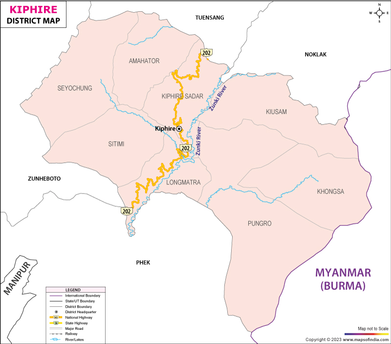
Kiphire district is located in the easternmost region of Nagaland, bordering Myanmar and it has Mount Saramati, the state's highest peak at 3826 metres; it is officially called the Land of Minerals, was carved out of erstwhile Tuensang district when Nagaland achieved statehood in 2004 and became the 9th District of the state and a region that was almost untouched by direct British colonial rule despite its proximity being colonized in the 1920s.
The district is hilly and mountainous all over, and is intersected by three rivers; the Naga Hills and the remoteness have made much of Kiphire still very difficult to reach even today. The district is spread over an area of about 1255 square kilometres and has only three officially recognized Naga tribes – the Sangtam, the Yimchungrü and the Sumi making the district one of the most concentrated tribal districts in Nagaland. Kiphire's remoteness, in the frontier county of Sagaing Region of Myanmar, and its breathtaking high elevation topography have placed it as one of the more isolated counties in the state and also as one of the more interesting emerging destinations for the adventurous traveller willing to take the long road to the east.
History & Culture
Kiphire is an unusual modern administrative tale for India. The area was also part of the North Eastern Frontier Agency (NEFA) in the larger district of Tuensang and unlike other areas in Nagaland, it had not been subjected to any political control or formal administration until 1947 when the transfer of power took place. In fact it was not until 1951 that a survey team, led by Assistant to the Deputy Commissioner Shri H. Zophianga, was sent out to locate a site for the first administration headquarters in this far-off corner of the Naga Hills, the true start of formal government in this region. The district did not come into existence until 2004 as a separate administrative unit from the district of Tuensang, and became the 9th district in Nagaland.
Culturally Kiphire is known by its three constituent tribes: Sangtam, Yimchungrü and Sumi which have their own language, attire, festival calendar and the majority of the population in the district are Christians (more than 97%) due to missionary activities in the Naga Hills till the 20th century. Similar to the rest of Nagaland, Village life is based around the village council led by a chairman who presides over the village development and solves any problems that arise within the village, which is divided into wards called khels. One such quirky local tradition has evolved around the village of Thanamir; in the 80s, the jawans of the Assam Rifles gave four apples to the village headman, who planted their seeds in his backyard; the trees that grew out of the apples have since given birth to an entire local apple-growing tradition celebrated every year during the state-level festival of apples that is the Thanamir Apple Festival, which attracts visitors from all over Nagaland to become the "apple capital" of the state.
Economy
Despite all these factors of remoteness, the hilly terrain and poor road network which have restricted the development of the economy, there is potential in horticulture and mineral resources in Kiphire which is one of the least developed districts of Nagaland.
Government Sector: Kiphire is the district headquarters and the Nagaland state government departments which are the administrative heads over the blocks and sub-divisions of the district are located in the town. Roads and infrastructure development continue to be a key and priority concern for the government, residents of the district and visitors to the district as a whole, with numerous travellers and locals commenting that a number of the roadways are incomplete and lack infrastructure toward the more remote villages in the district, such as Thanamir.
Public Sector: Kiphire is a land of minerals as per its nickname, some important mineral deposits are found here, and mining sites around Pokphur and the adjacent areas are defined as areas of interest in the public sector development plans of the district. Likhimro Hydro Project, with a planned International Trade Centre at Mimi close to the Myanmar border, is another public infrastructure project that will help to unleash the long-term economic potential of the district.
The district's climate is particularly conducive for services such as horticulture, especially in the colder foothill regions around Mount Saramati for the production of apples which are actually grown in abundance, as well as at lower elevations oranges, mangoes, guavas and bananas. This has resulted in the emergence of an agro-tourism economy with Thanamir village, where the local farmers and homestay operators have directly started enjoying the advantages of the rapidly increasing popularity of the district as a trekking spot. The neonic, wild honey collection, which is still carried out by traditional methods in the Mimi and Khonjiri area, in addition brings in some extra income for the rural population, which predominantly exists on subsistence agriculture.
Tourism
Although the tourism sector is still in its infancy, Kiphire has some of the most spectacular high-altitude scenes in the entire realm of Nagaland.
The highest peak in Nagaland at 3826 metres, Mount Saramati is one of the ultra-prominent peaks of Southeast Asia, situated on the India-Myanmar border and a challenging trek up the pristine forest, reports clear-weather summit views out as far as the Chindwin River in Myanmar.
The “apple capital” of Nagaland, Thanamir Village is also the base village for the Saramati trek and hosts the annual apple festival in the village, and is now becoming better equipped with homestays and guesthouses for trekkers who visit to take in the sights and sounds of the apple festival.
The rich biodiversity of the district of Kiphire includes the protected forest area of Fakim Wildlife Sanctuary, which lies in the Indo-Burma Biodiversity Hotspot.
The Khongjiri Stone Cave is one of the significant natural rock formations in the district and is considered one of the most geomorphologically interesting areas of Nagaland by the local tourism authorities.
The main waterways of the district, Zungki, Tizu and Likhimro rivers, provide opportunities for scenic river-based excursions for visitors in the more accessible lower altitude parts of Kiphire.
Mimi and Salomi Villages — situated on the fringes of the Myanmar border, these far-flung villages are of interest to travelers who want to experience the true idyll of Nagaland's least-visited, easternmost parts.
These areas combine to create a tourism profile of the region that is overwhelmingly dominated by adventure and undisturbed nature, which is in stark contrast to the more tourism-friendly circuits around Kohima and Dimapur, central Nagaland. The trip to Thanamir from Kohima can take around 7-8 hours and recent travel accounts highlight that the road to Thanamir is still a work in progress as roads are being built along the way.
Demographics
According to the 2011 Census, there were 74,004 people living in Kiphire district, 37,830 of them male, and 36,174 female, making the sex ratio 956 females per 1,000 males. The literacy rate of the district was 69.5%; male literacy was 74.88% and female literacy was 63.96%. The district remained rural with the majority of the population (more than 77%) residing in the villages of the district, with around 22.28% residing in urban areas, and mostly engaged in subsistence farming and forest-based activities.
Sangtam is the main language spoken by the people of the district with 46.28% of the population, closely followed by the Yimchungrü language which is used by 37.93% of the people and the small population of the Sumi language. The religion is overwhelmingly Christian with around 97.03% of the population following the faith, one of the highest rates in the country, signifying the historical missionary footprint in the Naga Hills.
Combined these numbers represent a largely rural and tribal population where literacy is relatively low and is a true measure of the difficulties of providing services like education and infrastructure in one of India's most inaccessible and mountainous districts. The population increase in Kiphire, over 38% between 2001 and 2011, indicates that the district is still in relatively early stages of both demographic and infrastructural development while its frontier setting and rugged terrain have also influenced the nature and speed of demographic and infrastructural development.
Administration
Kiphire district is divided into 5 blocks which are spread across the rugged mountainous terrain and the administration of the district is coordinated by 3 sub-divisions, namely Pungro, the trekking gateway for the Saramati in the district. The district is divided into 104 villages and one town (Kiphire) as the district headquarters. The maintenance of law and order is carried out by 3 police stations (one at Kiphire and Pungro, and another at Seyochung) and a police outpost.
The district administration, located in Kiphire town, runs the revenue for the district and its governance functions alongside the village administration where the head of the village is an elected chairman who has the authority to govern the village and resolve conflicts, a system prevalent throughout Nagaland which puts significant power in the hands of the traditional village institutions and administration.
| Official Name | Kiphire |
| Location | Nagaland |
| Area | 1255 sq. km |
| Population | 74004 |
| Language | Sangtam |
FAQs
Q1. How many villages are there in Kiphire district?
There are 104 villages in 5 blocks in Kiphire district.
Q2. How many people live in Kiphire district?
The population of the district in the 2011 Census was 74,004.
Q3. Which district is famous for Kiphire?
The area is synonymous with Nagaland state's highest peak, Mount Saramati, and the base village for treks up the mountain, Thanamir village, the "apple capital" of Nagaland.
Q4. What percentage of people are literate in the district of Kiphire?
According to the 2011 Census, the literacy rate of the district was 69.5%.
Q5. How many blocks are there in Kiphire district?
There are 5 blocks divided into 3 sub-divisions in the district.
Q6. What are the prime activities of people in Kiphire district?
Apart from forest-based livelihoods, such as wild honey making, and new mineral and hydropower development, subsistence agriculture and horticulture, especially the cultivation of apples around Thanamir, is a pillar of the district economy.
Q7. What is the way of administration at the local level in Kiphire district?
The district is organised into 5 blocks and 3 sub-divisions with the district administration based at the town of Kiphire and traditional village councils also have considerable authority.
Last Updated on October 27, 2026
