
During the British rule, it was declared a panchayat union. In 1958, it was made a township and finally in 2004, was declared a municipality. As it is a pilgrim centre, the people mostly earn their livelihood from the tourism industry. Apart from the sweets and other items of offering to the gods; toys, idols of deities and similar products are also sold in the city.
Places to See
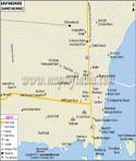
Besides the main Sri Ramanathaswamy Temple, there are many other places of tourists' interest in Rameswaram. Some of the important places to see here are:
Sri Ramanathaswamy Temple: A part of the Char Dham yatra, the temple is believed to have been built by Lord Rama in Dravidian style of architecture. In the 12th century, the Pandya Kings expanded the construction and built the current structure of the temple.
Five-faced Hanuman Temple: The temple is dedicated to Lord Hanuman and the image of the main deity has five faces namely, Lord hanuman, Lord Hayagriva, Lord Narsimha, Lord Garuda and Lord Adivarha.
Agnitheertham: There are many holy places of the Hindus in Rameswaram. The Agnitheertham is one such holy place. It is a collection of as many as 22 such places at the shore where the pilgrims take a holy bath. It is believed to be the place where Lord Rama took a bath and absolved himself from the sin of killing Ravana.
Dhanushkodi: It is a popular picnic and pilgrim spot in Rameswaram. Dhanushkodi is believed to be the place where the famous bridge with the floating stones known as Ram Setu is located. The place is also known for the varieties of migratory birds that flock here.
Gandamadana Parvatham: This is a hillock located about three kilometers to the north of the temple of Rameshwaram. It is considered to be a place that houses a foot print of Lord Rama on a Chakra.
How to Reach?
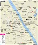
Being a pilgrim centre, it is thronged by large number of tourists. Hence, transportation facilities in the city are easily available. By road, the city is well connected to other cities of Tamil Nadu. There are many buses that ply within the city. Tourists can also avail the taxi services. Madurai is the nearest airport to Rameswaram, which is linked to major cities like Chennai, Bengaluru, Mumbai and Thiruchi. It is also connected to other major cities like Chennai, Palghat, Coimbatore and Thanjavur to name a few. Rameswaram railway station also provides connectivity to other cities and states via rail.
WBST270315
Last Updated on : May 11, 2026
| Find Distance from Rameshwaram to other Indian Cities | |||