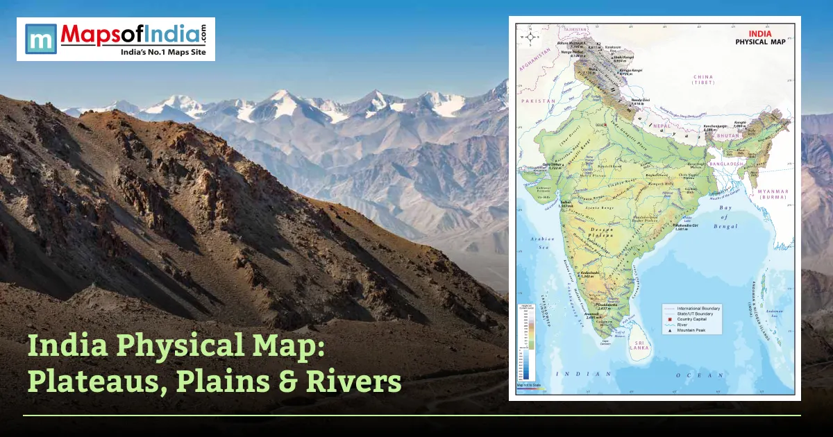
India is one of the most amazing geographical regions in the world that extends from the snow-clad Himalayas in the North to the tropical islands of the Indian Ocean. These natural features like mountains, rivers, plateaus, plains, deserts and coastal regions can be visualized with the help of the physical map of India. Physical maps are maps that emphasize the landforms and elevation of the nation, as opposed to political maps, which emphasize the boundaries of states and districts.
Learning about the Indian topography, climate, biodiversity, and natural resources can be of great benefit for students preparing for competitive exams like UPSC, SSC, CBSE, and others, for geography teachers who explain the geography of India and for those who love geography.
What Is a Physical Map of India?
A physical map of India is a map that represents the natural features of India, like mountains, plains, plateaus, rivers, deserts, coasts, and islands, using colours, shades and relief features. It is based on the geographical features instead of administrative boundaries and therefore is indispensable for the study of India's physiography.
Physical Map vs Political Map
Physical Map | Political Map |
| Shows natural landforms and elevation | Shows states, union territories, cities, and boundaries |
| Uses color gradients to represent relief | Uses different colors to distinguish administrative regions |
| Useful for geography and environmental studies | Useful for governance and administrative reference |
Why Physical Maps Matter?
A physical map is important because it:
- Helps students understand India's geographical features.
- Supports preparation for UPSC, SSC, State PSC, and school examinations.
- Explains how landforms influence climate and rainfall.
- Assists in disaster management and environmental planning.
- Helps understand agriculture, river systems, and biodiversity.
Major Physiographic Divisions of India
Traditionally, India is divided into six physiographic divisions, with distinct landforms and features.
The Himalayan Mountain Range
The Himalayas are the northern border of India and run through Jammu & Kashmir, Ladakh, Himachal Pradesh, Uttarakhand, Sikkim, Arunachal Pradesh and parts of West Bengal. These young fold mountains are home to some of the tallest peaks in the world, including Kanchenjunga, India's highest Mountain. The major rivers like Ganga, Yamuna and Brahmaputra are born here. The Himalayas provide a natural protection to the cold winds coming from Central Asia and also exert a significant control over the monsoon climate of India.
The Northern Plains (Indo-Gangetic Plain)
The Northern Plains are the depositional plains between the Indus, Ganga and Brahmaputra rivers, extending from Punjab in the west to Assam in the east. The fertile plains are intensively cultivated, and are among the densest in the world. It is the agricultural heart of India due to rich soil, plenty of water and a relatively flat land that is used for growing crops, notably wheat, rice, sugarcane and others.
The Peninsular Plateau
Peninsular Plateau is one of the oldest landmasses in India, and it is the area that covers the southern and central part of India. It comprises the Deccan Plateau, Malwa Plateau and Chota Nagpur Plateau. The plateau is endowed with iron ore, coal and manganese resources. The major rivers in this region are Godavari, Krishna, Narmada, Kaveri, etc. The plateau is flanked by the Western and Eastern Ghats.
The Indian Desert (Thar)
The Thar Desert is situated in the Thar belt mainly in the western part of the state of Rajasthan and is spread across Gujarat, Punjab and Haryana. It is typified by low annual rainfall, lack of vegetation and sand dunes. The main river of this area is the Luni River. The Thar, despite the extreme arid conditions, has wildlife that is unique, traditional settlements and large-scale irrigation projects such as the Indira Gandhi Canal.
The Coastal Plains
India possesses abundant coastal plains on the two seas, the Arabian Sea and the Bay of Bengal. Compared to the other regions, the Western Coastal Plain is quite narrow and encompasses the Konkan, Kannad and Malabar coasts. The Northern Circars and the Coromandel Coast belong to the Eastern Coastal Plain, which is wider in this region. The areas are suitable for fishing, farming, ports, tourism, and major commercial cities.
The Islands
The island territories in India comprise the Andaman and Nicobar Islands in the Bay of Bengal and Lakshadweep in the Arabian Sea. The Andaman and Nicobar Islands are famous for their dense forests, volcanic formations and rich marine life. Lakshadweep is largely made up of coral islands and is renowned for its lagoons, coral reefs and unspoiled beaches. The islands play an important strategic role in terms of India's maritime security.
Major Mountain Ranges Shown on the Physical Map
Mountain Range | States Covered | Highest Peak | Notable Fact |
| Himalayas | Jammu & Kashmir, Himachal Pradesh, Uttarakhand, Sikkim, Arunachal Pradesh | Kanchenjunga | Youngest fold mountain range |
| Karakoram | Ladakh | K2 (outside Indian administration) | Home to the Siachen Glacier |
| Aravalli | Rajasthan, Haryana, Gujarat | Guru Shikhar | One of the world's oldest mountain ranges |
| Western Ghats | Gujarat to Kerala | Anamudi | UNESCO World Heritage Site |
| Eastern Ghats | Odisha to Tamil Nadu | Mahendragiri | Discontinuous mountain range |
| Vindhya Range | Madhya Pradesh and Uttar Pradesh | Kalumar Peak | Traditionally separates North and South India |
| Satpura Range | Madhya Pradesh and Maharashtra | Dhupgarh | Source region for several rivers |
Major Rivers and Drainage Systems
Himalayan Rivers
The Ganga, Brahmaputra and Indus river systems are part of the Himalayan rivers. These rivers are perennial as they are sustained by the glaciers and rain. They transport vast quantities of water along with a rich alluvial loam, which makes the Northern Plains very fertile for farming.
Peninsular Rivers
Godavari, Krishna, Kaveri, Mahanadi, Narmada and Tapti are the rivers of the Peninsular river system. Most are from the Western Ghats or in the central highlands. The main source of flowing water in these rivers is the seasonal rainfall, and the ancient plateau landscape gives them relatively stable courses.
Comparison: The rivers of the Himalayas are perennial because they receive water from the glaciers as well as rainfall, while many of the rivers of the Peninsula are dependent primarily on monsoon rainfall and are less consistent in their flow.
Climate and Physical Features Interlinkage
The physical features of India have a direct effect on the climate of India. Cold continental winds are prevented from entering by the Himalayas, and the moisture-laden south-west monsoons are deflected towards the sides of the hills, resulting in heavy rainfall on the slopes of the mountains. The Orographic rainfall from the Western Ghats is also a feature on the western coast and the regions facing the rain shadow effect in the Deccan Plateau. The coastal plains have moderate climate conditions because of the influence of the sea, while the Thar Desert is responsible for the development of low-pressure areas to draw the monsoon wind.
Conclusion
A physical map of India presents a detailed picture of the nation's physical geography, including its high mountain ranges, the fertile Northern Plains, the ancient Peninsular Plateau, the dry Thar Desert, its coastal plains and its island regions. The knowledge of these physiographic divisions not only helps to improve geographical knowledge but also helps in understanding India's climate, agriculture, river system, biodiversity and economy. Regardless of academic study, competitive exam preparation, or general knowledge, the physical map has been a useful tool to delve into the geography of India.
FAQs
What is shown on a physical map of India?
A physical map of India shows natural features such as mountains, rivers, plateaus, plains, deserts, coastlines, and islands using relief shading and elevation colors.
How many physiographic divisions does India have?
India has six major physiographic divisions: the Himalayas, Northern Plains, Peninsular Plateau, Indian Desert, Coastal Plains, and Islands.
What is the difference between a physical map and a political map of India?
A physical map highlights natural landforms and elevation, while a political map displays states, union territories, districts, and administrative boundaries.
Which is the highest mountain range shown on India's physical map?
The Himalayan Mountain Range is the highest mountain system shown on India's physical map and includes Kanchenjunga, India's highest peak.
What are the major rivers shown on India's physical map?
Major rivers include the Ganga, Yamuna, Brahmaputra, Indus, Godavari, Krishna, Narmada, Kaveri, Mahanadi, and Tapti.
Why is the physical map of India important?
It helps students understand India's landforms, rivers, mountains, and geography for exams and general knowledge.