

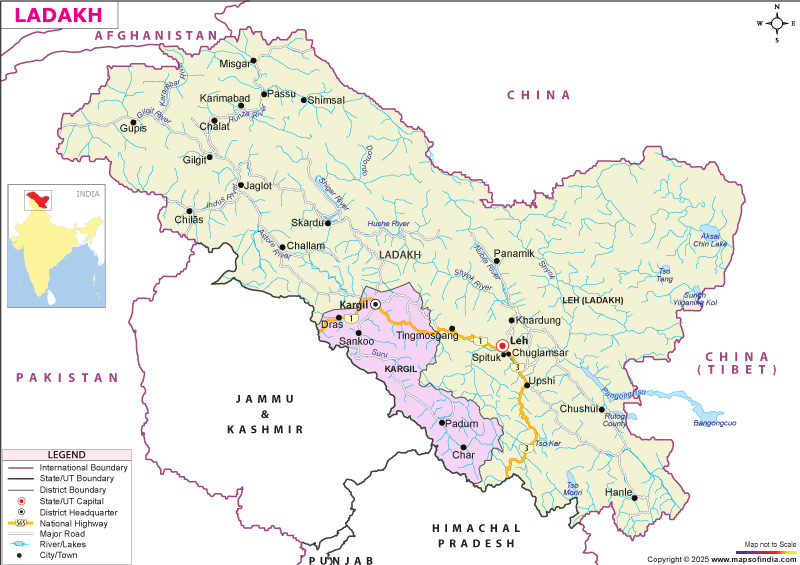




Whether you are planning a trip, studying the geography of northern India, or looking for administrative information, the map of Ladakh serves as a valuable reference for understanding the region's physical and political landscape.
About Ladakh
Ladakh is a U.T in the northernmost part of India. It is one of the highest populated and relatively secluded regions in the world, bounded to the north by the Karakoram Range and to the south by the Himalayas. The region is known for its dramatic landscapes, ancient monasteries, rich Buddhist heritage, unique culture, and adventure tourism.
The Union territory is bordered by Jammu and Kashmir, Himachal Pradesh, as well as various international boundaries and thus, it is strategically important for India.
Birth of Ladakh Union Territory
Ladakh was born from the state of Jammu and Kashmir. On August 5, 2019, the Union government had decided to revoke the special status of Jammu and Kashmir and remove Article 370 from Jammu & Kashmir. Union Home Minister Amit Shah introduced the Jammu and Kashmir Reorganization Bill, 2019, in the Parliament. On 31st October 2019, the Parliament passed an Act to make Ladakh a new Union Territory, which came into effect in August 2019.
As per the Jammu & Kashmir Reorganization Bill, the state saw a split. The Union Territory of Jammu & Kashmir and the Union Territory of Ladakh were formed on 31st October 2019, replacing the state of Jammu and Kashmir.
The creation of Ladakh as a separate Union Territory marked a significant administrative change in India's governance structure. Since then, the region has witnessed increased investments in infrastructure, connectivity, tourism, and public services under direct central administration.
Administrative Divisions
Ladakh comprises two administrative districts:
Leh District
Leh is the administrative headquarters of the Union Territory. It has a number of monasteries, mountain passes, adventure tourism places and government institutions.
Kargil District
The second district of Ladakh, Kargil is renowned for its historical importance, picturesque valleys, and cultural diversity. It is also a vital link between Ladakh and Kashmir.
There are two Autonomous Hill Development Councils for the two districts for local governance and developmental activities.
Administration
The Lieutenant Governor (LG) of the Union Territory of Ladakh is the administrative head of the administration, which is administered directly by the Central Government of India. The Lieutenant Governor is responsible for the administration of the Union Territory and is the authority for law and order, public administration and developmental efforts in relation to various government departments.
The Union Territory of Ladakh, headed by the first Lieutenant Governor, Radha Krishna Mathur, was formed on 31st October 2019. Since then, the administrative structure has been developing further, with emphasis being placed on the development of infrastructure, connectivity, education, health, tourism and sustainable development within the region.
Ladakh is divided into two districts, namely Leh and Kargil, with each district being governed by a Deputy Commissioner. Local governance is also enhanced with the presence of Ladakh Autonomous Hill Development Council (LAHDC) in both Leh and Kargil districts, which monitors planning and execution of development projects at the district level.
The Union Territory is governed by the High Court of Jammu & Kashmir and Ladakh and has several ministries and departments of the Central Government which assist in the administration of the people, their safety and socio-economic development.
Geography of Ladakh
The terrain of Ladakh is rugged mountains, high-altitude plateaus, deep valleys, glaciers and cold deserts. It lies between the Karakoram Range and the Great Himalayas, and is one of the highest inhabited areas in the world, ranging from approximately 3,000 metres to more than 7,000 metres above sea-level.
The mighty Indus River runs through Ladakh, and the valleys are formed by tributaries of the Indus like Shyok, Zanskar and Nubra. Ladakh is also home to spectacular high-altitude lakes including Pangong Tso, Tso Moriri, and Tso Kar, which attract tourists and wildlife alike. Several famous mountain passes, including Khardung La, Chang La, Fotu La, and Tanglang La, connect remote parts of the region and offer breathtaking views of the surrounding landscape.
Tourist Attractions
Ladakh is one of India's most sought-after travel destinations, attracting visitors with its dramatic landscapes, snow-capped mountains, ancient monasteries, crystal-clear lakes, and adventure opportunities. The region offers a unique blend of natural beauty, cultural heritage, and spiritual experiences.
Some of the most popular attractions include Pangong Tso, renowned for its changing shades of blue, Nubra Valley, famous for its sand dunes and double-humped Bactrian camels, and Tso Moriri, a serene high-altitude lake surrounded by mountains. Spiritual landmarks such as Hemis Monastery, Thiksey Monastery, Lamayuru Monastery, and Shanti Stupa showcase Ladakh's rich Buddhist heritage.
Adventure enthusiasts visit Ladakh for trekking, mountain biking, river rafting, camping, wildlife photography, and driving through iconic mountain passes like Khardung La and Chang La, making the region a year-round destination for nature lovers and thrill-seekers.
Transportation
Despite its rugged mountainous terrain, Ladakh is well connected through a network of roads and air services. Road transportation is the major mode of transport in the region, with the Srinagar–Leh Highway (NH-1) and Manali-Leh Highway providing linkages with the rest of India. These are usually available in the summer, subject to weather conditions and snowfall.
Ladakh has an adequate road network with a total of about 1,800 km, of which about 800 km are surfaced roads. The Border Roads Organization (BRO) is an important organization for maintaining these strategically important roads throughout the year.
Leh is the principal city of Ladakh, and the main airport is Kushok Bakula Rimpochee Airport, which has regular flights to Delhi and other major cities in India. Kargil also has an airport with limited operations. Although Ladakh does not currently have a railway station, the nearest major railheads are Jammu Tawi and Chandigarh, from where travellers can continue their journey by road.
Economy
The economy of Ladakh is largely driven by tourism, agriculture, horticulture, handicrafts, and government services. Major economic activities include:
- Tourism and hospitality
- Pashmina wool production
- Apricot cultivation
- Barley farming
- Yak and sheep rearing
- Handicrafts
- Defence-related employment
Culture and Festivals
Ladakh has a rich cultural heritage influenced by Tibetan Buddhism and local traditions. Popular festivals include:- Hemis Festival
- Losar
- Dosmoche Festival
- Sindhu Darshan Festival
FAQs
Q1: Where is Ladakh located?
Ladakh is a Union Territory in northern India, bordered by Jammu & Kashmir, Himachal Pradesh, and international boundaries.
Q2: What does the Ladakh map show?
The Map of Ladakh shows district boundaries, major towns, roads, rivers, lakes, mountain ranges, and important tourist attractions.
Q3: When did Ladakh become a Union Territory?
Ladakh became a Union Territory on 31 October 2019 under the Jammu and Kashmir Reorganisation Act, 2019.
Q4: How many districts are there in Ladakh?
Ladakh has two districts—Leh and Kargil.
Q5: What are the top tourist attractions in Ladakh?
Popular attractions include Pangong Tso, Nubra Valley, Tso Moriri, Hemis Monastery, Shanti Stupa, and Khardung La.
Q6: What is the total area of Ladakh?
Ladakh covers a total geographical area of approximately 59,146 square kilometres, making it one of India's largest Union Territories.
Q7: Which countries and regions border Ladakh?
Ladakh is bordered by Jammu & Kashmir to the west, Himachal Pradesh to the south, China to the north and east, and Pakistan-occupied territories to the west and north-west.
Last Updated on: July 06, 2026
