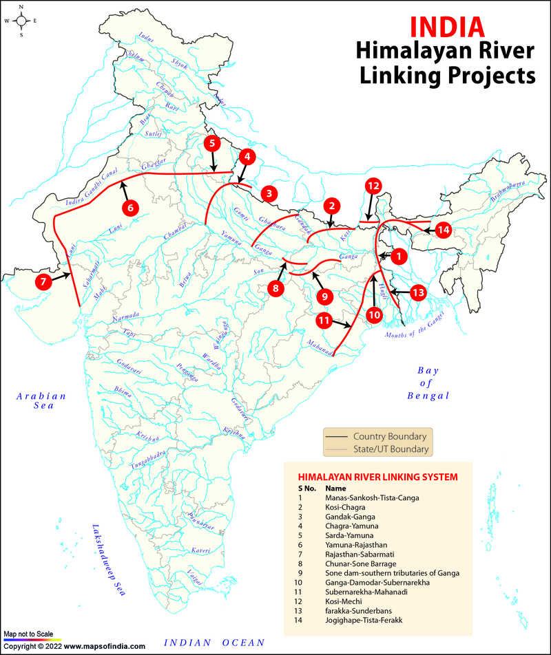
The National River Linking Project (NRLP) is an important national project in India. Under this, 30 links covering 37 rivers all over India will be constructed to ensure equitable distribution of water. It is managed by the National Water Development Authority (NWDA) which comes under the Ministry of Jal Shakti. This project is divided into two major components:
- The Peninsular Component
- The Himalayan Component
The Himalayan Component
The Himalayan Component of NRLP includes the construction of dams and reservoirs along the Ganga and Brahmaputra rivers in India, Nepal, and Bhutan for the storage of surplus water. With this, the surplus water in the eastern tributaries of the Ganga will be transferred to the western tributaries. The main Brahmaputra river will also be linked to the Ganga.
This will help in more hydropower generation and flood control along with the conservation of monsoon flow for irrigation.
As of January 2022, the pre-feasibility reports for all the 14 links proposed under the Himalayan Component have been completed. Out of them, feasibility studies of 4 links have been completed and survey & investigation work for the preparation of the feasibility report of 6 links has also been completed.
Himalayan River Linking Projects
There are a total of 14 links proposed under the Himalayan Component of NRLP. They are:
Manas - Sankosh - Tista - Ganga (MSTG) Link
States Concerned: Bhutan and India (Assam, West Bengal, and Bihar)
Status: Feasibility Report completed; Detailed Project Report in progressKosi - Ghagra Link
States Concerned: Nepal and India (Bihar, and Uttar Pradesh)
Status: Pre Feasibility Report completedGandak - Ganga Link
States Concerned: Nepal and India (Bihar, and Uttar Pradesh)
Status: Feasibility Report completed for the Indian PortionGhaghara - Yamuna Link
States Concerned: Nepal and India (Bihar, and Uttar Pradesh)
Status: Feasibility Report completed for the Indian PortionSarda - Yamuna Link
States Concerned: Nepal and India (Bihar, Uttar Pradesh, Uttarakhand, Haryana, and Rajasthan)
Status: Feasibility Report completed for the Indian PortionYamuna - Rajasthan Link
States Concerned: Gujarat, Rajasthan, Haryana, and Uttar Pradesh
Status: Feasibility Report completedRajasthan - Sabarmati Link
States Concerned: Gujarat, Rajasthan, Haryana, and Uttar Pradesh
Status: Feasibility Report completedChunar - Sone Barrage Link
States Concerned: Bihar and Uttar Pradesh
Status: Feasibility Report completedSone Dam - Southern Tributaries of Ganga Link
States Concerned: Bihar and Jharkhand
Status: Pre Feasibility Report completedGanga (Farakka) - Damodar - Subarnarekha Link
States Concerned: West Bengal, Odisha, and Jharkhand
Status: Feasibility Report completed; Detailed Project Report in progressSubarnarekha - Mahanadi Link
States Concerned: West Bengal and Odisha
Status: Feasibility Report completedKosi - Meichi Link
States Concerned: Nepal and India (Bihar and West Bengal)
Status: Pre Feasibility Report completedFarakka - Sunderbans Link
States Concerned: West Bengal
Status: Feasibility Report completedJogighopa - Tista - Farakka (Alternate) Link
States Concerned: Assam, Bihar, and West Bengal
Status: Pre Feasibility Report completed
- The Feasibility Reports of the Mana - Sankosh - Tista - Ganga Link and the Farakka - Sunderban Link have been circulated to their concerned states during 2020-21.
- The Feasibility Reports for Sarda -Yamuna Link and Ghaghara- Yamuna Link were not circulated because the work in Nepal is not yet completed.
- Based on the Detailed Project Report of the Pancheshwar Dam in Nepal, the Feasibility Report of the Sarda - Yamuna Link is undergoing modifications.
- Survey and Investigation work for the preparation of Feasibility Reports of the Sone Dam- Southern Tributaries of Ganga Link and the Kosi - Ghaghra Link has been completed.
- The Kosi - Meichi Link that lies in Nepal and the Jogighopa - Tista - Farakka Link, an alternative for MSTG are not targeted for the preparation of Feasibility Reports.
- National Science Museums in India
- Jyotirlinga Shrines
- Geological Map of India
- Canals in India
- Major Lakes in India
- Heritage Map of India
- Pin Code Zones in India
- Per Capita Income of India
- Major Sea Ports
- Languages in India
- Climate map of India
- Parlimentary Constituencies in India
- Tourist Circuits in India
- Metallic Minerals in India
- Cold Desert Map
- Major Electricity Generator Plants
- Religions In India
- Major Earthquakes in India
- Major Hydro Power Plants
- Indian States and Union Territories
- Cabinet Ministers
- Map of Indian States and Union Territories Enlarged View
- Physiographic Map of India
- Religious Places in India
- Geographical Map of India
- Dams in India
- India Coal Reserves Map
- India Political Map Enlarged View
- India Satellite Map
- Topographic Map of India
- Population Map Of India
- Natural Hazard Map of India
- Tourist Map of India Enlarged View
- Tier I and Tier II Cities of India
- Cyclone Prone Areas in India
- Outline Map of India Enlarged View
- Wine Producing Regions in India
- Map of Major Airports in India
- Birth Rate in India
- Statehood Movements in India
Last Updated on: November 13, 2025

