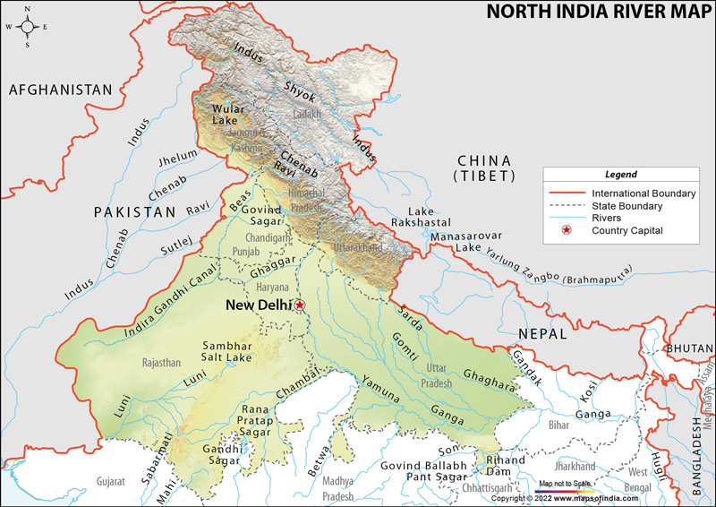
| Name | Length (km) | Area | Originates From | Ends in | Places Benifited |
|---|---|---|---|---|---|
| Indus | 3100 | 3,21,290 Sq.Km. | In Tibet Kalish Range 5080 mts. | Arabian sea | India and Pakistan |
| Ganga (Bhagirati) | 2480 | 3,37,00 Sq.Km. | Gangothri | Bay of Bengal | Uttar Pradesh, Uttarakhand, Bihar, West Bengal |
| Yamuna (Jamuna) | 1370 | 3,59,000 Sq.Km. | Garhwall in Yamunotri | Bay of Bengal | Delhi, Haryana and UP |
| Gomati | 900 | N.A | Gomat Taal | Ganges | Uttar Pradesh |
| Ghaghara | 1080 | 127,950 km2 | Himalayas | Ganges | Uttar Pradesh |
| Indus | 3200 | 1,165,000 km2 | Tibetan Plateau | Arabian sea | Jammu and Kashmir ( India ) , Pakistan, China |
| Chenab | 960 | N.A | Bara-lacha la | Indus | Himachal Pradesh, Jammu and Kashmir ( India ) , Pakistan |
| Jhelum | 813 | N.A | Pir Panjal Range | Chenab River | Jammu and Kashmir ( India ) , Pakistan |
| Beas | 470 | 20,303 km2 | Rohtang Pass | Sutlej | Himachal Pradesh, Punjab ( India ) , Pakistan |
| Sutlej | 1450 | 66,317 km2 | Mount Kailash | Arabian sea | Himachal Pradesh, Punjab ( India ) , Pakistan |
| Ravi | 720 | Himachal Pradesh | Chenab River | Himachal Pradesh, Punjab ( India ) , Pakistan |
Last Updated on : January 14, 2026
