- India has a distinct culture and is home to one of the world's earliest and finest civilizations.
- It extends from the snow-capped Himalayas in the north to sun-drenched coastal towns in the south and humid tropical forest areas on the southwest coast, from the fertile Brahmaputra valley in the east to the Thar Desert in the west.
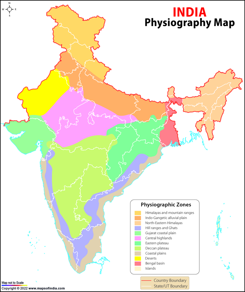
Physiographic Division of India
- The geological formation of India is very diverse because Indian rocks come from various geologic periods dating back to the Eoarchean Era.
- Its geographical land area is divided into the Dharwar System, Vindhyan System, Cuddapah System, Deccan Trap System, Archaean System, Gondwana System, and Quaternary System.
- India has shorelines of 7516.6 km and a total land border of 15200 km, with the Tropic of Cancer passing almost through its centre, passing through Rajasthan, Madhya Pradesh, Gujarat, Jharkhand, West Bengal, Chattisgarh, Tripura, and Mizoram.
- India is largely located on the Indian Plate, which is the northern portion of the Indo-Australian Plate, and whose continental crustal part forms the Indian subcontinent. Besides the various physiographic features, India is divided into six physiographic divisions: Northern Plain; Peninsular Plateau; Northern and North-eastern Mountain; Coastal Plains; Indian Desert; and Islands.
The Himalayas:
- The Himalayas are among the world's newest fold mountain ranges, formed primarily of sedimentary materials.
- They run from the Indus River to the Brahmaputra River in the east. It is made up of three parallel ranges: the Himadri (Greater Himalayas), the Himachal (Lesser Himalayas), and the Shiwaliks (Outer Himalayas).
The Northern Plains
- The Northern Plains are developed by alluvial sediments carried by the rivers Indus, Ganga, and Brahmaputra.
- These plains stretch for around 3,200 kilometres from east to west. The typical breadth of these plains is between 150 and 300 kilometres.
- The greatest depth of alluvium deposits is from 1,000 to 2,000 metres.
- These are separated into three primary zones from north to south: the Bhabar, the Tarai, and the alluvial lowlands.
The Indian Desert
- To the northwest of the Aravali Mountains lies the Great Indian Desert. It consists of an undulating terrain, characterized by longitudinal dunes and barchans.
- his region has an arid environment with little plant cover due to minimal rainfall of less than 150 mm per year. Because of these distinguishing characteristics, this is also referred to as Marusthali.
The Indian Plateau
- It is generally triangular with its base parallel to the Gangetic Plain and its apex extending towards the south of the country.
- It is a hard ancient mass of igneous and metamorphic rocks that is part of the Gondwanaland tectonic plate.
Peninsular Plateau
- The Peninsular Plateau is bounded on the west by the Western Ghats, on the east by the Eastern Ghats, and on the north by the Satpura, Maikal range, and Mahadeo hills.
- Local names for the Western Ghats include the Nilgiri hills in Tamil Nadu and Karnataka, the Sahyadri hills in Maharashtra, and the Cardamom and Anamalai hills in Kerala.
Islands:
- India has two large island groupings, one located in the Bay of Bengal and one in the Arabian Sea.
- The Bay of Bengal island grouping is made up of around 572 islands/islets. The entire collection of islands is separated into two major groups: the Andaman Islands in the north and the Nicobar Islands in the south. They are divided by a body of water known as the 10° channel.
- Lakshadweep and Minicoy are two Arabian Sea islands. These islands are located between 280 and 480 kilometres off the coast of Kerala. The whole island chain is made up of coral deposits.
General Maps
- National Science Museums in India
- Jyotirlinga Shrines
- Geological Map of India
- Canals in India
- Major Lakes in India
- Heritage Map of India
- Pin Code Zones in India
- Per Capita Income of India
- Major Sea Ports
- Languages in India
- Climate map of India
- Parlimentary Constituencies in India
- Tourist Circuits in India
- Metallic Minerals in India
- Cold Desert Map
- Major Electricity Generator Plants
- Religions In India
- Major Earthquakes in India
- Major Hydro Power Plants
- Indian States and Union Territories
- Cabinet Ministers
- Map of Indian States and Union Territories Enlarged View
- Physiographic Map of India
- Religious Places in India
- Geographical Map of India
- Dams in India
- India Coal Reserves Map
- India Political Map Enlarged View
- India Satellite Map
- Topographic Map of India
- Population Map Of India
- Natural Hazard Map of India
- Tourist Map of India Enlarged View
- Tier I and Tier II Cities of India
- Cyclone Prone Areas in India
- Outline Map of India Enlarged View
- Wine Producing Regions in India
- Map of Major Airports in India
- Birth Rate in India
- Statehood Movements in India