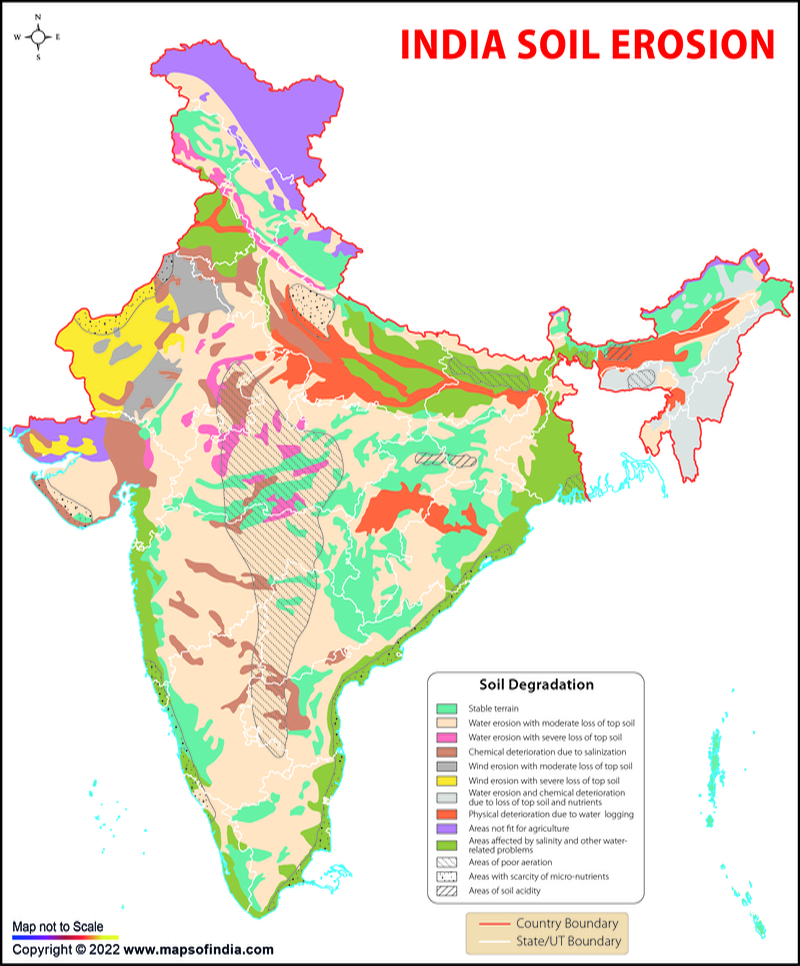
Environmental problems are a major concern for the whole world. They affect the flora, fauna, humans, lands, etc. Soil erosion is among the major problems in India that affect both the quality and quantity of the soil.
The Indian Council of Agricultural Research (ICAR) has classified eight major soil types in India. They are:
- Alluvial soil
- Black soil
- Red soil
- Lateritic soil
- Arid and desert soil
- Mountain soil
- Alkaline and Saline soil
- Peaty soil
All these soil types have different characteristics. For instance, Black soil is derived from basalt rock, red soil is derived from granites, gneisses, and crystalline rocks, and mountain soil near mountain slopes, and some in semi-arid regions, All these soil types are suitable for the production of different crops.
Whenever the uppermost layer of soil is displaced, the land of that particular area gets degraded leading to soil erosion. This affects the quality of soil which ultimately lowers the quality of crops being produced on that soil.
Soil Erosion in India
Soil erosion refers to the natural process in which the top layer of soil is carried away or displaced due to physical sources like wind and water. It is a slow and steady process that results in loss of topsoil, ecological degradation, and soil collapse.
Other causes of soil erosion include heavy rains, strong winds, flowing rivers, glaciers, deforestation, overgrazing, shifting cultivation, etc. All this has led to problems like lowered crop productivity, clogging of waterways that lead to floods, air pollution, turning habitable regions into deserts, and reduction in the efficiency of dams, embankments, and drainage.
In India, there are no set standards for measuring the effects of soil erosion. Different agencies and organisations use their methods to determine the same. According to the National Academy of Agricultural Sciences (NASS), 92.4 million hectares of land were degraded due to soil erosion as of 2010. The data of the areas in the Indian states affected due to soil erosion is as follows:
The state-wise cultivable area affected by soil erosion in India
| State | Area (in Hectares) |
|---|---|
| Andhra Pradesh (including Telangana) | 8093 |
| Arunachal Pradesh | 666 |
| Assam | 3248 |
| Bihar | 851 |
| Chhatisgarh | 3733 |
| Delhi | 28 |
| Goa | 1 |
| Gujarat | 984 |
| Haryana | 306 |
| Himachal Pradesh | 982 |
| Jammu and Kashmir | 1369 |
| Jharkhand | 3219 |
| Karnataka | 7522 |
| Kerala | 490 |
| Madhya Pradesh | 12262 |
| Maharashtra | 8799 |
| Manipur | 122 |
| Meghalaya | 302 |
| Mizoram | - |
| Nagaland | 46 |
| Orissa | 2227 |
| Punjab | 229 |
| Rajasthan | 19029 |
| Sikkim | 45 |
| Tamil Nadu | 2308 |
| Tripura | 109 |
| Uttar Pradesh | 13075 |
| Uttarakhand | 1018 |
| West Bengal | 1332 |
| Total | 92400 |
Major Developments
For the development of the regions affected due to soil erosion, the government is taking several steps. Under the Rashtriya Krishi Vikas Yojana, the Reclamation of Problem Soils has been started as a sub-scheme to assist in the reclamation of lands affected by alkalinity, salinity, and acidity. An amount of ₹58.76 crores was also released to the states during the period from 2016-17 to 2020-21. Out of which area worth ₹0.24 lakh has been developed.
Moreover, location-specific bio-engineering soil & water conservation measures, watershed management interventions, soil reclamation measures for saline, alkali, waterlogged and acid soils, and selection of suitable crops including agroforestry interventions to prevent and manage land degradation have been developed by ICAR. More than 8000 projects related to watershed development were sanctioned during 2009-10 to 2014-15 by the Department of Land Resources.
Around 7.60 lakh water harvesting structures were created during the period from 2014-15 to 2021-22. It has brought an additional land of 16.27 lakh hectares. With a target of bringing 49.50hecatres of land, the government of India has sanctioned a sum of ₹8134 crores under the Watershed Development Component of Pradhan MantriKrishiSinchayeeYojana 2.0 (WDC-PMKSY-2.0). 1099 projects have also been sanctioned as of March 2022 which covers 49.21 lakh hectares of land.
- National Science Museums in India
- Jyotirlinga Shrines
- Geological Map of India
- Canals in India
- Major Lakes in India
- Heritage Map of India
- Pin Code Zones in India
- Per Capita Income of India
- Major Sea Ports
- Languages in India
- Climate map of India
- Parlimentary Constituencies in India
- Tourist Circuits in India
- Metallic Minerals in India
- Cold Desert Map
- Major Electricity Generator Plants
- Religions In India
- Major Earthquakes in India
- Major Hydro Power Plants
- Indian States and Union Territories
- Cabinet Ministers
- Map of Indian States and Union Territories Enlarged View
- Physiographic Map of India
- Religious Places in India
- Geographical Map of India
- Dams in India
- India Coal Reserves Map
- India Political Map Enlarged View
- India Satellite Map
- Topographic Map of India
- Population Map Of India
- Natural Hazard Map of India
- Tourist Map of India Enlarged View
- Tier I and Tier II Cities of India
- Cyclone Prone Areas in India
- Outline Map of India Enlarged View
- Wine Producing Regions in India
- Map of Major Airports in India
- Birth Rate in India
- Statehood Movements in India
Last Updated on: November 13, 2025

