

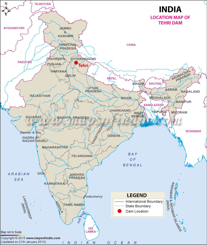





Constructed as an earth and rock-fill embankment dam, Tehri Dam stands as an example of modern engineering in a geologically complex region. The project has transformed the region by creating one of the largest reservoirs in India while supplying clean energy and water resources to millions of people.
The Tehri Dam Project was conceived to address the increasing demand for electricity, irrigation, and drinking water in northern India. Now it serves several sustainable development goals, such as renewable energy production, provision of water for big cities like Delhi and modulation of the seasonal river flow. The project is also part of some of the most talked-about infrastructure projects in India, due to its massive environmental and social impacts.
Where is Tehri Dam Located?
Tehri Dam is situated in Tehri Garhwal district of Uttarakhand, approximately 70 kilometres from Rishikesh and about 110 kilometres from Dehradun. It is situated in the vicinity of the town of New Tehri, which was created after the original town of Tehri was inundated with the construction of the reservoir.
The dam is constructed across the Bhagirathi River, which is one of the main head streams of the Ganga River. At Devprayag, the Bhagirathi River meets with the Alaknanda and becomes the holy Ganga River.
The approximate geographical location of Tehri Dam is 78.48° E longitude and 30.38° N latitude. Nestled in the Garhwal Himalayas, the dam is surrounded by scenic mountains, forests, and valleys, making it both an engineering landmark and a popular tourist destination.
The place is well connected by road from Dehradun, Haridwar and Rishikesh. Rishikesh is the closest railway station, and Jolly Grant Airport near Dehradun is the nearby airport, which provides easy access for visitors from all over India.
A detailed map of Tehri Dam provides information to the visitors pertaining to its location in the state of Uttarakhand and its adjacent towns, road connectivity, geographical features and landscape information, etc.
History of Tehri Dam
Construction of a big dam on the Bhagirathi was first proposed in the 1960s when there was a high demand for electricity and water in northern India. The project was approved after detailed geological investigations and feasibility studies were carried out over several years.
The construction works started in 1978, but progress was slow because of technical difficulties, environmental problems, legal problems and public protest. As the dam is in a seismically active Himalayan area, comprehensive engineering studies were made to ensure the safety of the structure.
A major highlight of the project's success was the start-up of the reservoir filling in the early 2000s. The main dam of the hydroelectric project was completed, and the first phase of the hydroelectric project went into operation in 2006.
Relocation of the historic town of Old Tehri and many surrounding villages was a part of the construction. The rehabilitation work, along with environmental issues and concerns regarding the seismic safety of the Tehri Dam, brought this dam into the spotlight of India. Despite these challenges, the project has become a cornerstone of India's renewable energy sector.
Technical Specifications of Tehri Dam
Tehri Dam is among the tallest earth and rock-fill dams in the world and the highest dam in India.
The dam is 855 feet tall and 575 metres long at its crest. Its massive embankment consists primarily of rock and earth materials designed to withstand significant water pressure and seismic activity.
The reservoir created behind the dam has a gross storage capacity of about 3.54 billion cubic metres (BCM), enabling it to store large volumes of water for power generation, irrigation, and drinking purposes.
The dam is equipped with high-capacity spillways that safely discharge excess water during heavy rainfall and monsoon seasons, thereby reducing flood risks downstream.
The first stage of the hydroelectric plant has an installed generation capacity of 1,000 MW with four 250 MW generation units. Besides that, the Tehri Hydroelectric Complex can also be enhanced with the Tehri Pumped Storage Plant and the Koteshwar Dam, which further boosts the electricity generation capability of the region.
Tehri Dam Project
The Tehri Dam Project was built as a multipurpose river valley project to satisfy the increased resource needs of northern India.
One of its primary objectives is hydroelectric power generation, producing clean and renewable electricity that reduces dependence on fossil fuels. The project makes a large impact on the Northern Grid and helps to ensure energy security in several states.
The stored water also benefits farmers by providing irrigation water for around 2.7 lakh ha of agricultural land in the states of Uttar Pradesh and Uttarakhand, where the use of water would be difficult during dry seasons.
One of the other primary goals is to provide potable water for millions of people. The project supplies potable water to the population of Delhi, Uttar Pradesh, Uttarakhand and adjacent areas to meet the growing demand for potable water in the urban areas.
The reservoir also serves as an important flood moderator because river flow is controlled during the monsoon season when heavy rains occur, helping to prevent flooding downstream in more sensitive locations.
Tehri Lake
Tehri Dam was built, creating Tehri Lake, which is one of the largest man-made lakes in India. The lake occupies the valleys and has emerged as a prominent geomorphological feature in Uttarakhand.
It has a huge storage capacity that means that it can provide water throughout the year to power plants, irrigate crops, and supply drinking water. The reservoir is not only used for development, but it has also become a tourist and adventure sport centre.
Tehri Lake is surrounded by beautiful nature, which is a favourite place for photographers, nature lovers and outdoor enthusiasts all year round. It is serene, with the hills of the Himalayas on the surrounding horizon, with amazing views at sunrise and sunset.
Importance of Tehri Dam
Tehri Dam plays a strategic role in India's infrastructure and water resource management. It plays a very significant role in the production of renewable energy through the generation of hydroelectric power that is used for industrial, commercial and domestic electricity generation.
The project has contributed to the growth of the region in Uttarakhand with regard to employment opportunities, tourism facilities and road connectivity. The economy of New Tehri town and its surrounding facilities has changed due to its development.
The dam is also one of the largest multipurpose water projects in northern India, supplying drinking water and irrigation for the cities of Delhi, Uttar Pradesh, and the surrounding areas, beyond Uttarakhand.
Economically, Tehri Dam supports agriculture, industries, urban development, and sustainable energy production, making it an essential national asset.
Environmental and Social Impact
As with many large-scale projects, there have been good and bad results from Tehri Dam.
The biggest of these was the inundation of the Old Tehri town and several villages around it. Thousands of families were shifted to rehabilitation centres in New Tehri and other places prior to the filling up of the reservoirs.
Rehabilitation and compensation programmes by government agencies were implemented to support families of the displaced with the provision of houses, land and civic facilities. The resettlement, however, was met with mixed reactions, with a lot of residents expressing concerns about livelihood and rehabilitation.
Environmentalists also voiced their apprehensions about issues of biodiversity loss, river ecology changes, sedimentation and effects of large reservoirs in the delicate Himalayan environment.
The dam was built in an earthquake-prone area, so engineers applied state-of-the-art seismic design standards when they built it. Structural stability and safety during operation are monitored with continuous monitoring systems and new safety measures, allowing for assessments of structural stability under varying geological conditions.
Tourism at Tehri Dam
The Tehri Dam is now one of the emerging tourist spots of Uttarakhand and is known for adventure sports, engineering and nature lovers.
Visiting between October and June would be the ideal time to enjoy the weather and outdoor activities. In the post-monsoon months, you can enjoy skies that are clear and spectacular views of the surrounding mountains.
The adventurous activities around the lake of Tehri have increased impressively in recent years. There are activities for visitors to enjoy:
- Boating: There is plenty of room for speed boats and leisure boats to cruise around the reservoir.
- Thrill Seeking: If you are one of those who want to enjoy high-speed water sports, there is an option for you too.
- Kayaking: The water is calm and suitable for novices and experts in kayaking.
- Camping: Lakeside camps offer opportunities for overnight stay in a picturesque setting in the Himalaya.
The times and entry requirements for an activity or a tourism facility may differ. Before travelling, visitors should contact local tourism authorities and/or the operator of the activity.
Today, Tehri Dam is not only recognised as India's tallest dam but also as an important destination where engineering excellence, natural beauty, renewable energy, and adventure tourism come together in the heart of the Himalayas.
| Tehri Dam Facts | |
|---|---|
| Dam Name | Tehri Dam |
| State Name | Uttarakhand |
| Type of dam | Embankment, Earthen and Rock-fill |
| Operated by | Tehri Hydro Development Corporation Ltd. |
| Nearest City | New Tehri |
| Impounds | Bhagirathi River |
| District Name | Tehri Garhwal |
| Surface Area | 52 km2 (20 sq mi) |
| Lat / Long | 30.377677, 78.477339 |
| Total Storage Capacity | 3.54 km3 |
| Purpose | Multipurpose |
| Construction began | In 1978 |
| Opening date | In 2006 |
| Power Generation Capacity | 1,000 MW |
| Height | 260.5 meters |
| Length | 575 meters |
| Width (crest) | 20 meters |
| Dam Volume Content | 27032 TMC |
| Type of Spillway Gates | Radial |
| Spillway Type | Chute |
| Spillway Gates | 3 |
| Project | Tehri Dam Project |
Last Updated on : July 08, 2026
