About
Calangute is a coastal census town in Bardez taluka in the North Goa district on the coast of Arabian Sea about 13 kilometres north-west of the state capital, Panaji. Known popularly as the “Queen of Beaches”, it is the most famous beach and popular tourist spot in Goa because of its long stretch of golden sands that stretches out for almost seven kilometres. It may be derived from the Konkani language term ‘Kollo Ghott' or ‘Koli-gutti ', which means a small fishing hamlet, highlighting the village's humble beginnings as a small fishing village long before it became a worldwide tourist attraction.
Calangute is not a district in itself but a very popular town and beach resort in North Goa district, which also includes the equally popular beach towns of Candolim in the south and Baga in the north. This process of a sleepy Portuguese fishing and farming village going from being one of the least-traveled beaches in India to one of the most-traveled beaches in the world is indicative of the larger story of how Goa has evolved into a global tourist attraction. Calangute today is synonymous with sunbathing, water sports, colourful nightlife, beach shacks and a cosmopolitan mix of domestic and international visitors and a backbone of Goa's tourism economy, because during the tourist season the influx of tourists is almost half of the actual population of city.
History & Culture
Calangute's history dates back to pre-colonial times when it was a small fishing village and farming community on the northern coast of Goa with a small population based on subsistence living where the economy was not meant for export but feeding the people. A turning point in its history occurred in the mid-16th century when the entire Bardez region came under Portuguese rule and this influence is still reflected in the town's architecture, religion and social practices which have been shaped by it for nearly 400 years and the impacts were so strong that even today they are visible. The first Catholic parish was founded in 1595 and by 1741 the Church of St. Alex had been finished and is the town's most recognisable colonial-era icon and a symbol of the Christianisation that transformed the local community during the Portuguese era.
During the 18th and 19th centuries, Calangute became an important place for "mudança de ares" or change of air for the rich people of Panjim and Mapusa who trekked in this direction to get some relief by the sea. The sleepy fishing village became an internationally known countercultural beach town when the "flower children" arrived in the mid-1960s, discovering Calangute's beaches and laid-back environment. Goa became a part of India following the Portuguese occupation on December 19, 1961 and the hippies came in the mid-1960s and changed the fate of Calangute with its beaches and laid-back environment. By the 1980s, this organic hippie trail had been replaced by a more commercial resort economy, with beach shacks, guest houses and organised resort infrastructure continuing to characterise the town to this day. Culturally Calangute has blend of Goan Catholic and Hindu culture, with feasting and festivities taking place at St. Alex Church and Hindu temple festivals in the neighboring vaddos, as well as a strong presence of the Goan Carnival tradition and Konkani folk music, dance and songs alongside a cosmopolitan and party culture brought in through decades of tourism.
Economy
The economy of Calangute is dominated by the service sector and tourism, yet there are still remnants of the past economic sectors that are agrarian and fishing. The basic unit of local governance in the Government Sector is the Village Panchayat, set up in 1971, and covering nine vaddos such as Saunta Vaddo, Khobra Vaddo, Naika Vaddo and Tivai Vaddo, in addition to the offices of the Goa Tourism Development Corporation, coastal police and municipal sanitation and infrastructure bodies dealing with the pressure of a high footfall tourist town. In comparison to the small town size of Calangute, the Public Sector is relatively sparse, consisting of government schools, primary health centres and coastal regulatory and environmental agencies which face frequent problems in beach erosion and waste disposal, and unauthorised construction.
The local economy is dominated by the services sector, with the majority of residents living off the back of the hospitality and food and beverage sector, water sports and retail. Beach shacks, restaurants, and budget guest houses line the coast and operators of water sports such as parasailing, jet-skiing and banana boating help to serve the steady flow of domestic and international tourists. Fishing was the main industry of the town and still is today, on a smaller scale, producing seafood for local restaurants and flea markets and souvenir vendors, supplementing the income that is directly related to the number of tourist visitors. The influx of migrants from other Indian states, especially Karnataka, Maharashtra and Uttar Pradesh, has become a characteristic of the local workforce, as a large part of jobs in the hospitality and service sectors are filled by migrant labour attracted by the hospitality and service sector in Goa, which is one of the biggest in India.
Tourism
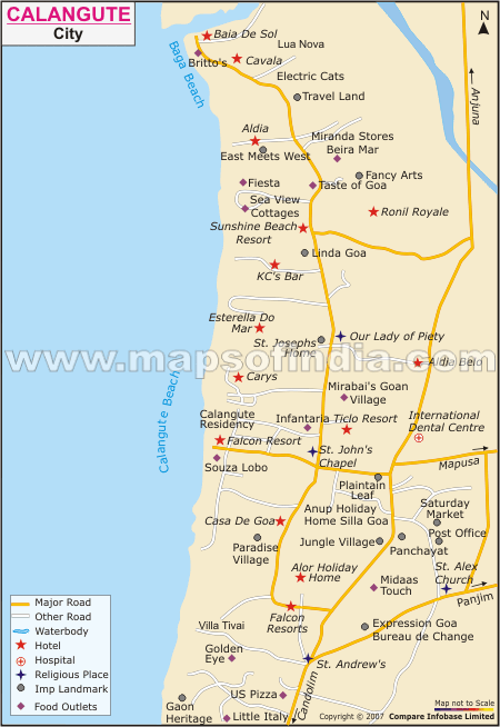
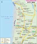
The beach, which is still the most popular and commercialised beach in Goa, is Calangute's defining feature and economic lifeline, as the town's identity and livelihoods are tied to it. Calangute beach is popular for sunbathing, beaches, surfing, and various other water sports and the promenade has beach shacks selling Goan seafood and international cuisine as well as a thriving flea market that sells souvenirs, handicrafts and clothing.
St. Alex church is the main heritage landmark of the town even though the original structure was constructed in 1741 in a clearly Portuguese style ; it is a reminder of the colonial past. History buffs also go to the nearby Aguada Jail Museum, which was constructed by the Portuguese to fortify the land and then converted into a prison.
Apart from the beaches the city is also famous for its nightlife characterised by many bars, beach clubs and late-night parties that make it one of the liveliest towns in Goa especially in the tourist season when we see a sharp increase in the number of tourists visiting the place.
Wellness tourism has also been on the rise with several yoga centres and ayurvedic retreats surrounding the town that offer a more relaxed alternative to the party lifestyle and this particular aspect of the city has made it even more popular among the people who come here from all around the world.
Baga and Candolim beaches are neighbouring beaches and are visited together with Goa's popular beach of Calangute in one single trip, which is short. If one wants to visit the place October to March is the best time since the weather is mild and comfortable for people to travel to different places and enjoy to the fullest since the beach shacks, water sports operators and nightlife places are at peak.
Demographics
As per Census of India 2011 Calangute has a population of 13,810, of which males accounted for approximately 54% and females for 46% therefore the gender ratio is decent. Its overall literacy rate is approximately 73% that is higher than the national average, with male literacy at 78 percent and female literacy at 67% , and about 10% of the population was under six years of age. It should be noted that this census population is for Calangute as a permanent community and this is not to mention the even larger transient population of tourists and seasonal workers, which greatly inflates the size of Calangute, especially during the tourist season from October to March.
Post-liberation migration from mainland Indian states like Uttar Pradesh, Karnataka and Maharashtra has also added to linguistic and cultural diversity of the town with significant numbers of people speaking Hindi and Marathi, in addition to Goa speakers of the native Konkani language. The overwhelming majority of residents are Christians and Hindus apart from people of other religions residing in the city with peace and harmony.
A mix of the Portuguese colonial influence and the town's pre-colonial Hindu heritage continues to influence Calangute's festivals, architecture and social life along with the living traditions of the place that has importance not just for the natives but also has gained popularity among the people all over the world and as a result of which tourists from different places come to visit this city.
Administration
Calangute is a census town located in Bardez taluka of the North Goa taluka and falls under the administrative jurisdiction of the North Goa district with the administrative responsibilities resting on the village panchayat that was constituted in 1971 and has an elected Sarpanch who is responsible for the provision of civic amenities, sanitation, development and maintenance of the town and other local infrastructure.
The Panchayat has nine vaddos (wards) including Saunta Vaddo, Khobra Vaddo, Agar Vaddo, Umta Vaddo, Porba Vaddo, Naika Vaddo, Maddo Vaddo, Gaura Vaddo and Tivai Vaddo which are the local residential clusters within the village limits.
Even though Calangute has a small permanent population, it retains its own political identity as a constituency of the Goa legislative assembly; this is because it has a presence in the Lok Sabha in the Indian Parliament as its own electoral district in North Goa.
As there are no sub-divisions or the component villages, many of the higher administrative functions like police, tourism, coastal functions and revenue are handled from the Bardez taluka and the North Goa district administrative divisions.
| Official Name | Calangute |
| Location | North Goa district |
| Area | 7.01 sq. km |
| Population | 13810 |
| Language | Konkani |
FAQs
Q1: How many villages does Calangute have?
It does not have any villages but it is divided into 9 vaddos (wards) under its Village Panchayat.
Q2: What is the population of Calangute?
13,810.
Q3: For what is Calangute known?
Calangute beach is the most popular and iconic beach of Goa; it is popularly called the "Queen of Beaches" for its golden sand, water sports, beach shacks and vibrant nightlife.
Q4: Calangute is located in which district?
North Goa district.
Q5: Which is the best time to visit Calangute?
October to March.
Q6: How did Calangute get its name?
Calangute is said to have got its name from a little fishing hamlet "Koli-gutti", which it was before it was established as a tourist centre.
Q7: What is the main economic activity in Calangute?
Hospitality industry, water sports, beach shacks and retail. The traditional fishing industry is a smaller source of employment.
Last Updated on : August 03, 2026
| Find Distance from Calangute to other Indian Cities | |||