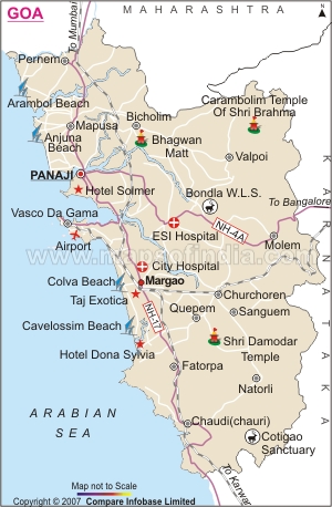
The area of Goa is 3,702 square kilometers. The area of
Goa is divided into two Revenue districts, namely
North Goa and
South Goa.
These districts have their headquarters at
Panaji and
Margao respectively. Boundaries of Goa State are defined in the North by the Terekhol River, which separates it from
Maharashtra, in the East and South by
Karnataka State and West by Arabian Sea. Goa lies in Western Coast of India and is 594 Kms (by road) away from Mumbai city. The area of Goa comprises 11 talukas. For the purpose of implementation of development programs the State is divided into 12 community development blocks.
Administratively the State is organized into two districts North Goa comprising six talukas with a total area of 1736 sq. kms, and South Goa comprising five talukas with an area of 1966 sq. kilometers. There are 383 villages in total of which 233 are in
North Goa district and 150 in
South Goa district. As per the 2001 census, there are 44 towns of which 14 are Municipalities and remaining are census towns.
Get some more details on
Location of Goa
Last Updated on: May 12, 2026