






About
Chamba District of Himachal Pradesh State is an Indian (Himalayan state), one of the most beautiful and historic district. It is situated in the north-west of the state, and while its major mountains, beautiful temples and culture may be famous, it might also all seem a little peculiar.
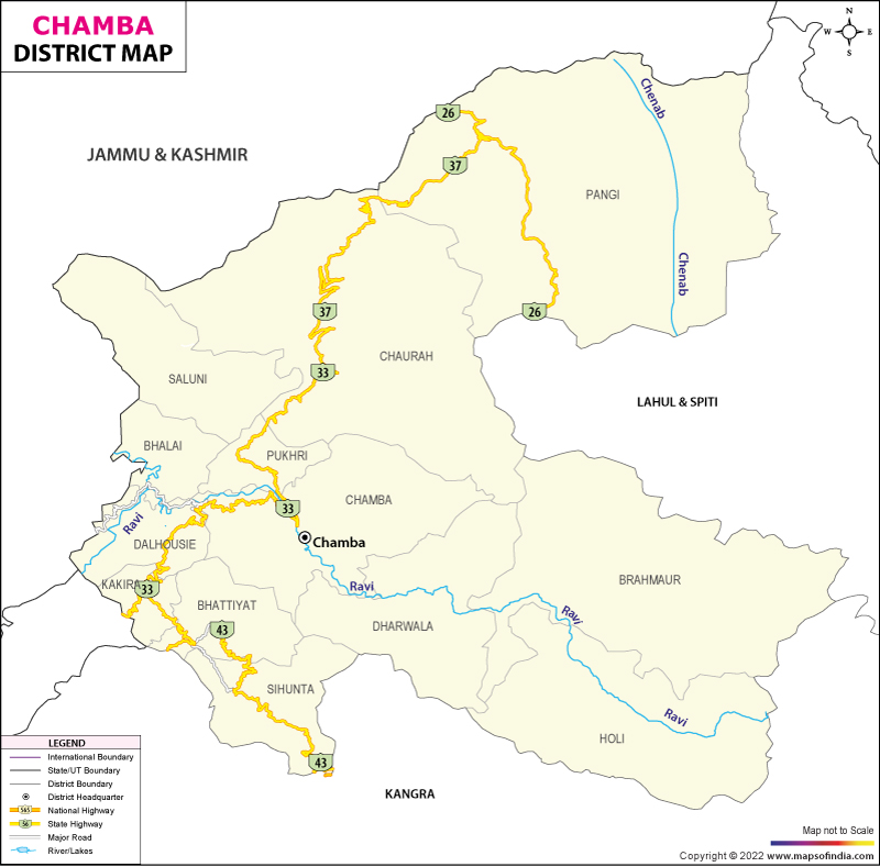
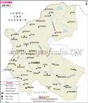
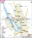
The Chamba district map shows the situation of the district in the western Himalayas and the terrain differences. The map depicts the area of the Chamba district that contains major settlements like Bharmour, Pangi, Dalhousie and Churah, which are distinguished by high forelands and a different culture from time immemorial. The Chamba district map is helpful for research, travel and planning purpose which gives a reference of the Chamba district in terms of its terrain and connectivity.
Chamba's old cities are mainly famous for their ancient temples, traditional handicrafts, folk heritage and natural beauty. The district is also home to some tribal communities, replete with their own customs and way of life, who add appeal to the cultural offerings on view in this corner of the state.
History & Culture
Chamba was a significant hill state of the western Himalayas in previous years. The rulers of Chamba were great lovers of art, architecture, literature, and religion and built many temples, palaces and public buildings. During the medieval times, the Kingdom survived and remained intact despite the political upheaval in Northern India.
The Chamba district map also contains information regarding the historic trade routes looping into the kingdom, with other territories like Kashmir, Ladakh and Punjab. The Chamba district map is used by historians in order to understand the importance of the mountain passes as well as the rivers and valleys, which have contributed to the development of the district. The situation of the Chamba district is also shown on this map, and this relative isolation accounts for many traditional customs and cultural practices which have survived for centuries.
The district's strengths continue to be its culture. Some of the local culture is folk music, dances, fairs and festivals of the Chamba area. The Minjar Fair is the most popular festival of the district. It is held every year in Chamba town to mark the agricultural season and is a popular event. Important events apart from this include other festivals that are celebrated, like Suhi Mata Mela, Manimahesh Yatra and the local religious functions celebrated under the village deities.
The district is really very famous for the Chamba Rumal that is a fabulous needle embroidery that one can see. Today, we have skilled trades related to crafts that include weaving, metalwork and wood carving. Regarding the medium of speaking, one can speak different languages across the district, like Chambyali, Gaddi, Churahi, Pangwali and Hindi.
Economy
Principally, the economy of Chamba district is based on agriculture, horticulture, animal husbandry, tourism and government activities. The district has a mountainous topography, thus leading to economic activities ranging from region to region.
Employment generation in the Government Sector is very important. The government agencies and departments associated with education, healthcare, public works/construction, forestry, revenue administration and rural development offer significant job possibilities. The Chamba District map is used very often for developmental planning, road construction and providing public services in distant areas.
There is a significant contribution from the Public Sector originating from hydroelectric development and infrastructure projects. The presence of the river, Ravi and its tributaries has made hydropower generation an important economic activity. Better roads, bridges, and communication connections provided for in public programs have opened up many remote areas. This map of the Chamba district helps in the planning of infrastructure development and resource management at suitable locations. The Chamba district map is also used by development agencies in matters of regional planning programs.
The services sector has experienced consistent development in the last few decades. Providing education and healthcare services, banking, transportation and hospitality and/or tourism-related services are leading industries contributing to the income of the district.
Farmers grow maize, wheat, barley and paddy depending on the altitude and climatic conditions. With the expansion in the development of apples, walnuts, and temperate organic products like apricots, horticulture has gained importance. Even in tribal areas like Bharmour and Pangi, rearing sheep and goats is still a supporting livelihood to many rural households, which forms a part of the larger animal husbandry.
Tourism
Tourism is seasonal and one of the largest industries in the district. Chamba is gifted with nature, history and religion in abundance.
Chamba may be a small town, but there are a lot of sightseeing spots within. Lakshmi Narayan Temple Complex is one of the oldest architecture complex of temples in Himachal Pradesh. Bhuri Singh Museum: Hues of History Bhuri Singh Museum offers spectacular art which features a wide range of paintings, manuscripts, sculptures and artefacts detailing the minutiae of the pre-Independent era.
Famed Dalhousie figures into the district, a former British Raj hill station that is pretty much known for its pleasant weather and mountainous pine trees. Khajjiar, also known as 'Mini Switzerland of India', and the vibrant green fields provide beautiful views. This is the hilly road linking Dalhousie with Khajjiar and the town of Chamba in the Chamba district, so one can obtain a Chamba district map while travelling to have some convenience.
The other one in the vicinity is the revered Manimahesh Kailash Peak and its adjacent Lake. Others who go to the lake, which draws thousands of followers annually, the Chamba Map provides detailed information on the difficult route. The Chamba map is immensely helpful for pilgrims travelling on their own, as it gives a detailed location of this tortuous path, little known to travellers. The Chamba district map can be used to plan for walks and treks in the Bharmour and Pangi areas in the district.
Chamunda Devi Temple, Chamera Lake, Rang Mahal, Kalatop Wildlife sanctuary and Sach Pass are the other attractions for the visitors. Chamba is one of the attractive toursim area of HP, it is a combination of all.
Demographics
Census 2011 mentions the population of Chamba district being 519080. It had 80 people per sq km and a sex ratio of 986 females for every thousand males. Generally, the rural population is more than 90 percent in a large multiple areas overall. To add on, nearly 72% people can read and write in the district.
The Chamba district map is also a tool in helping demographers to observe settlement patterns and density at several areas. The research can also be conducted on the basis of tribal and non-tribal areas in Chamba through the help of the Chamba district map. Also, the Chamba district map is a tool that can help to understand about landform, climate, etc., which also relate to factors associated with literacy/ accessibility / economic development.
Hindi is the official language and the other languages/dialects in this district belong to western Pahari varieties: Chambyali, Gaddi, Churahi Pangwali, etc. It is mixed with the cultural and geographical characteristics of this district.
Administration
Administrative division Chamba district falls within the Kangra Division of Himachal Pradesh. The district headquarters are located in Chamba town, the only major administrative, judicial and commercial centre in the area. Due to the wide expanse of hills and thinly populated settlements, the district administration has ensured that governance, delivery services as well as developmental initiatives in regard with needs assessment, implementation mechanism, etc., are focused across remote terrain.
The Deputy Commissioner (DC), who is the chief executive head of district, is responsible for revenue administration and execution of government schemes, disaster management, and election duties. Coordination of various departments of government with a dash of developmental works is also something that is under control of that respective authority.
Chamba district is administratively divided into ten tehsils, namely Bhalai, Bhattiyat, Brahmaur, Chamba, Chaurah, Dalhousie & Holi Valley region along with Sihunta, Pangi and Saluni. These tehsils also constitute a decentralized unit of revenue and administration, enabling the implementation of government programmes at that level. Beneath the level of tehsil are sub-tehsils, which help relieve administrative pressure and improve public service delivery in remote regions.
Panchayati Raj Institutions are nothing but the local self governance at a primary level. A lot of Gram Panchayats exist in the district which manage village development and maintains infrastructure, cleanliness, welfare projects, etc. at a community level. It is these institutions that serve a crucial link in the chain, between remote areas and district administration, which overreaches their villages.
The district judiciary operates via courts at Chamba and other specified locations to adjudicate both civil and criminal matters. Different departments of the Government, such as those dealing with education, health, agriculture, horticulture and forestry, public works as well as rural development and social welfare have offices throughout the district to serve local residents.
According to the 2011 Census based village records, Chamba has approximately 1,110 villages on the slopes of mountains and in river valleys, along with remote high-altitude regions. But the large number of villages also indicates its rural nature. Along similar lines, a number of the settlements exist in relatively low weight geography, which will probably present constant bureaucratic improvements to deal with and administrations' conveyance. However, rising long-term government investment has made it a lot more available in terms of the availability of highway systems, along with bridges' lifetimes as well as telecommunications structure along with electronic governance.
Since it is a disaster prone area — landslides, flash floods, heavy snowfall and earthquakes being the potential threats in this area—the district administration gives utmost priority to their need for preparedness related to disaster or any emergency response for timely action.
FAQs
Q1: What is the total number of villages in Chamba district?
Chamba district has approximately 1,110 villages according to Census-based administrative records.
Q2: What is the population of the Chamba district?
According to the Census of India 2011, Chamba district had a population of 519,080 people.
Q3: What is the Chamba district famous for?
Chamba district is famous for its ancient temples, Chamba Rumal embroidery, Minjar Fair, Dalhousie, Khajjiar, Manimahesh Lake, Himalayan landscapes and rich cultural heritage.
Last Updated on : August 24, 2026
