
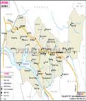
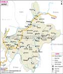
| Facts of Mandi District | |
|---|---|
| State | Himachal Pradesh |
| District | Mandi |
| District HQ | Mandi |
| Population (2011) | 999777 |
| Growth | 10.92% |
| Sex Ratio | 1007 |
| Literacy | 81.53 |
| Area (km2) | 3950 |
| Density (/km2) | 253 |
| Tehsils | Mandi, Chachyot, Thunag, Karsog, Jogindernagar, Padhar, Ladbhadol, Sundernagar, Sarkaghat, Balh |
| Lok Sabha Constituencies | Mandi, Hamirpur |
| Assembly Constituencies | Karsog (SC), Sundernagar, Nachan (SC), Seraj, Darang, Jogindernagar, Dharampur, Mandi, Balh (SC), Sarkaghat |
| Languages | Hindi, English, Pahari, Mandyali |
| Rivers | Beas, Satluj |
| Lat-Long | 31.653381,76.924667 |
| Travel Destinations | Bhootnath Temple, Rewalsar Lake, Prashar Lake, Pandoh Dam, Macchial Lake etc. |
| Government Colleges/Universities | Vallabh Government College, Government College (Kasrog), Jawaharlal Nehru Government Engineering College, Noble College of Education, Himachal Dental College, Industrial Training Institute etc. |
Last Updated on : May 08, 2026