






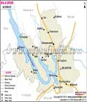
About
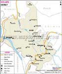
Right where Himachal Pradesh begins, Solan District greets visitors with factories rising beside untouched mountain views. From the goddess Mata Shoolini Devi - the area’s main spiritual guardian - comes the name that shapes both place and identity here. Known far and wide for mushrooms, it earned a nickname tied to bold farming firsts long before others followed. Red gold isn’t about treasure but something grown in rows across fields - the tomato harvest fuels local pride just as much. High up near Kasauli and Chail, cool air drifts through thick pine forests, while down below, Baddi and Nalagarh hum with steady heat and activity. Shifting heights shape how life grows here - one zone feeds into another without clear breaks.
History & Culture
Out here among the hills, Solan's past comes together through several old royal territories. Long before India became independent, this area was made up of separate kingdoms - places like Baghat, Baghal, then Kunihar and Kuthar too; also Mangal, Beja, followed by Mahlog, ending with Nalagarh. Back then, Baghat stood out among the rest. Its palace shifted to Solan once the British set up a military base nearby. Trouble hit hard when Nepalese Gorkha forces swept through in the early 1800s. Forts changed hands fast amid heavy fighting. Only after Britain stepped in did the original kings regain control. That stretch of land took shape as an official area when borders shifted on September 1, 1972. Solan and Arki joined forces after splitting from old Mahasu territory. Life here is set to an ancestral beat, where dancers gracefully step into historical patterns passed down through the ages, most notably in the rhythmic Nati. Life pulses with the clang of Karnal horns, voices rising in songs shaped by mountain air. Instead of fading, customs blend into daily work, even factory shifts. Community ties hold strong, built less on rules and more on shared mornings at tea stalls. Even as machines hum nearby, village gatherings still echo with laughter that sounds centuries deep. Out front among Solan’s yearly happenings sits the Shoolini Mela - three days of bold color and rhythm each June on the Thodo Ground.
Economy
Out here, Solan stands strong - its economy steady, built on a foundation few others match across Himachal Pradesh. This place? It runs the show when it comes to industry, quietly powering much of what keeps the state moving forward.
Government Sector
Deep in the hills, Solan sits close to the state capital- only forty-six kilometers away - and holds steady as a hub for governance. Not just any town, it hosts courtrooms where rulings shape lives, offices that keep records flowing, departments managing everyday order. From farming research units to branches of statewide control, jobs grow here like crops after rain. Power lines hum beside paper files stacked high in rooms lit by flickering bulbs. People commute daily, drawn by paychecks tied to policy, bound by schedules set long before sunrise. Deep in the hills, the government operates Dr. Yashwant Singh Parmar University of Horticulture and Forestry at Nauni - a leading center for farm science and job creation. Instead of private control, these services stay under public oversight, stretching into clinics, roads, and woodland protection throughout the lower Dhauladhar range.
Public Sector
Out here, big government-run factories and huge construction projects shape how things work. Near Rajban, the CCI cement plant runs full-time, part of daily life for many workers. Over in Kasauli, the Central Research Institute quietly leads vaccine development, tied directly to national health goals. Instead of private lenders, local farming relies on state-supported credit groups and countryside loan offices. These hubs pump money into growing vegetables when most regions have stopped.
Services Sector
Most of the economy in Solan now comes from services - about equal parts factories, visitors, and schools. Down in the lowlands, the BBN Industrial Hub has grown into Asia’s biggest area for making medicines. That zone holds many private plants, shipping out drugs across the world. A large portion of India’s medicine exports start right there. Chail and Kasauli aren’t just scenic - they’ve become centers where luxury stays create steady work for drivers, handicraft sellers, among others. Instead of fading, Solan has shifted gears; today it hosts a cluster of respected schools, colleges, even specialist training centers. Though remote, these spots fuel opportunity far beyond their size.
Tourism
Hidden among India’s quieter corners, Solan reveals itself along hushed trails winding near forgotten royal homes. Through these hills, footsteps trace routes beside colonial-era houses draped in moss. Morning breath fogs the glass panes of buildings left from British times. Soaring cables dart between slopes where forests dip into valley floors. Behind ancient walnut trunks sit small stone shrines waiting beyond tree shadows. Each turn reveals something different - stone steps worn by decades, market stalls selling wool caps, sudden views of distant snow peaks. Adventure mixes with stillness here, without one overpowering the other. Nestled among pine-and-oak-covered hills, the peaceful town of Kasauli exudes an enchanting, historic atmosphere. Cobblestone paths weave through foggy woodlands, offering a serene escape from the rush of modern life. Built long ago in 1853, Christ Church stands firm at its heart. From Monkey Point, views stretch far beyond the trees into open sky. Perched high up where mist often drifts through pine trees, Chail holds the old royal palace made long ago by Patiala's king. Atop these hills sits a cricket field unlike any other - higher than most clouds wander, reaching 2,444 meters into the sky. Not many places can claim such a quiet patch of grass so near to heaven. This one does. Hidden among pines, Barog wears quiet charm where old train tracks trace a UNESCO path through hills. Its tunnel stands time-worn, built long ago beneath forest shadows. Steam whispers still echo faintly near iron rails that climb slowly toward Shimla. Trees arch overhead like silent watchers of passing carriages. Cold mountain air lingers around stone walls lined with moss. Trains crawl here without hurry, slicing through mist at dawn. Each chug feels distant yet clear in the hush between peaks. Deep in the heart of Solan stands a temple glowing with quiet devotion. It rises not loud but certain, honoring Mata Shoolini. People come slow and steady, drawn by something older than words. This place holds time like it's heavy. Worship here feels less spoken, more lived. Generations have shaped its steps without needing signs or slogans. No fanfare, just presence. Jatoli Temple sits a short drive beyond Solan town. Rising above the landscape, it claims distinction among Asian shrines dedicated to Shiva- the tallest of its kind. Crafted slowly, year after year, builders shaped its striking pyramid form. Thirty years passed before the work reached completion. Design details unfold across tiers, each level adding height, weight, presence.
Demographics
High up in the mountains sits Solan, a place carved into Himachal Pradesh, India. Back when census counters came around in 2011, they counted 5,80,320 souls calling it home - a solid chunk of the state’s people map. Of those, men made up 3,08,754, while women stood at 2,71,566. While quiet on the surface, its pulse beats through local trade, jobs, and governance networks. Not loud, yet deeply woven into how things run across the region. Backward in step with the nation's numbers, Solan counts 880 women for every thousand men. Out of line with broader trends, that figure tells a quiet story about who lives how here. Slow shifts appear when looking back through each round of population counts. About three out of four people in Solan district can read and write, which reflects progress in learning over time. While nearly nine out of ten men have basic education skills, just under eight out of ten women do, leaving a noticeable difference between them. That gap sits at roughly 12.6 points when compared directly. Improving schools and access still takes up much of the local government's focus today. Starting off, there are nine talukas within the district, acting as smaller units for handling local administration and gathering statistics. Spread out widely, the region spans diverse terrain where people live more densely in some parts, less so in others.
Administration
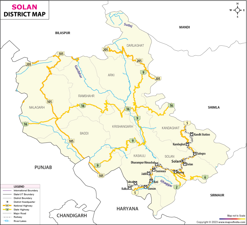
Hidden among peaks and factories alike, Solan District runs without clutter. Who's in charge? The District Magistrate - also called Deputy Commissioner - pulls duties from an office tucked inside the Solan town secretariat. Not flashy, just steady. Running through fields and offices alike, the district splits into zones that handle land records, keep people safe, and then stretch out toward villages needing growth - each piece carved into sections, smaller parts, and working units shaped for tasks on the ground. The count of administrative units stands at a mix spread through Solan district’s core towns. Seven revenue divisions cover areas like Solan, Kasauli, Nalagarh, Arki, Kandaghat, Baddi, plus Ramshehar. Smaller zones include Darlaghat, Krishangarh, Kunihar, Mamligh, Panjehra, Parwanoo, and Loharghat - seven sub-units total. Village count reaches 2,383, grouped under 240 local councils and five development clusters. Town governance features one city corporation based in Solan, alongside key municipal councils and an industrial body managing BBNDA.
| Official Name | Solan |
| Location | Himachal Pradesh |
| Area | 1936 sq. km |
| Population | 580320 (2011 census) |
| Language | Hindi, Punjabi, English |
FAQs
Q1: How many villages are there in Solan district altogether?
Solan district has 2,544 Census 2011 village records in this directory, grouped under 9 sub-districts in Himachal Pradesh.
Q2: How many people live in Solan district altogether?
That number comes from official census records: 580,320 people live in Solan District.
Q3: What is the Solan district famous for?
Home to the title "Mushroom City of India," Solan District stands out. Baddi holds Asia’s biggest hub for drug production, quietly shaping its identity. Perched high, Chail Palace welcomes visitors with a cricket field above all others. Kasauli charms with old-world hill station grace from colonial times. Rising tall, the Jatoli Temple claims distinction as Asia's loftiest shrine dedicated to Lord Shiva.
Last Updated on : July 10, 2026
