
About
Hidden behind the towering Dhauladhar peaks lies Kangra, home to more people than any other district in Himachal Pradesh. Once called Kan-gari - meaning Ear-fort - the name has roots in an old tale. That story tells how the demon Jalandhara lost his ear here after being struck down by Lord Shiva. What began as legend now shapes the land's identity. Over five thousand seven hundred thirty-nine square kilometers wide, this place beats like a pulse - culture and government moving through its veins. Step by step, the land rises, beginning calm near Shivalik’s quiet slopes at five hundred meters, then lifting sharply toward bare mountain edges that scrape five thousand meters skyward. Neighbors wrap around it - Chamba, Lahaul and Spiti, Mandi, plus Hamirpur and Una - and between them all, Kangra holds space where flat Punjab fades into cold Himalayan air.
History & Culture
Before lines on paper divided land, flowing waters shaped it - the Ravi, the Beas, the Sutlej carving their own borders across time. Ages ago, people called this place Trigarta, a realm strong enough to echo through myth, its name held within the Mahabharata’s oldest hymns. Power stayed here, passed down through bloodlines unbroken by time. The Katoch rulers trace roots deeper than most thrones on Earth. Stories pile up where empires rise and fade. Standing strong through ages, the old Kangra Fortress has seen Himalayan times shift slowly by. Image credit goes to Mrinal Pal, captured under the Getty Images banner. Long ago, power centered on the towering Kangra Fortress, known then as Nagarkot. Its riches, spoken of far and wide, drew attackers time after time. Invaders came - Mahmud of Ghazni first, later the Mughals, then the Gurkhas - but still it stood. Then, without warning, the earth shook in 1905. After that ruin, influence slipped away, never returning. The land’s balance changed, quietly, for good. Kangra breathes culture like morning air. Out of it grew the famed miniature paintings - soft strokes, earth-toned hues, stories of longing and faith drawn gently across paper. Not far off, voices rise in Kangri, a warm-tongued member of the Western Pahari speech. Rhythms shape days here: feet stamping Jhoori on dusty ground, songs winding through valleys during Sair when fields lie bare after harvest. When Navratri comes, sound spills down slopes, laughter tangled with drumbeats, everyone pulled into the fold. Painting, word, dance - the land hums without pause.
Economy
Farming still holds strong here, yet daily life shifts toward new kinds of work. While old ways remain, change creeps in through quieter paths.
Government Sector
Deep in the hills, power flows through paperwork and paychecks tied to the state. Winter brings lawmakers downhill to Tapovan’s halls, where debates echo under high ceilings. Lives here hinge on postings - teachers at chalkboards, nurses behind clinic counters, clerks sorting files by window light. Offices spread like roots beneath the surface of daily life. Not money from markets but salaries from ministries keep many homes afloat.
Public Sector
Standing strong at the core of Kangra’s finances are public enterprises and banks. Nationalized lenders, alongside bodies such as HRTC - handling transport across Himachal - along with post offices, create countless steady roles in tech and office work. Not far behind, military presence shapes daily life; bases dot the region, fueling local spending through paychecks and retiree benefits that flow into homes. What keeps many households afloat isn’t commerce or tourism - it’s uniforms, service records, and monthly disbursements marked “defense.”.
Services Sector
Out of nowhere, tourism takes up much room in the business world. Hospitality shows up just as strong, standing close beside it. Sustainable commerce weaves through both, quietly shaping how things work. Private enterprise leans heavily on these areas, more than most realize.
Tourism
If history grabs your attention, Kangra offers old tales in quiet spots. Spirit finds its pace among mountain temples, tucked beyond the noise. Sharp turns call out to thrill seekers along sudden mountain drops. Above the clouds, near jagged ridges, stands HPCA Stadium - bold against the skyline of Dharamshala. Photographed by Kandrp Gupta, shared through Getty Images. Floating between foggy slopes, Dharamshala rises, joined by McLeod Ganj just above. This place shelters the 14th Dalai Lama alongside Tibet’s government far from home. Known quietly as "Little Lhasa," it carries that name without show. Temples settle softly into tight streets, their stillness meeting constant talk in roadside cafés filled with moving strangers. From here, the well-worn trail up to Triund begins without fuss - just steps leading upward through pines. Below the mountain walls sits the beautiful HPCA Stadium. Surrounded by jagged ridges wearing caps of snow, it's often called among the loveliest spots anywhere to see live cricket played. Up along the higher slopes, though, Bir Billing’s famous wind rides warm air upward, pulling paragliders in from every corner of the planet. This quiet mountain spot has earned a bold reputation - staging global paragliding contests year after year. Pilots glide effortlessly here, lifted by dependable warm breezes that sweep up the slopes. Far from city noise, it stands recognized as India's top launch site for flight adventures. Travelers arrive not just for records but for skies wide enough to lose themselves in.
Water holds the shape of ancient stone, mirroring what time left behind. Built during the eighth century, these temples rise from unbroken rock like thoughts carved into a mountain face. Some call them Ellora's echo, tucked high where the air grows thin. Stillness settles around a pool that catches every line, each shadow cast by precision hands long gone.
Demographics
Kangra district counted 1,510,075 people in the 2011 census. With every square kilometre housing around 263 individuals - about 680 per square mile - the place feels lived-in but never crowded. Between 2001 and 2011, numbers climbed by 12.77%, a steady rise without sudden spikes. Just under six percent call cities home, while most stay rooted in villages. For every thousand men, there are 1,012 women - a rare tilt toward balance. Nearly 86 out of every hundred can read and write, showing quiet progress over years. Caste groups recognized in official records form 21.15%; tribal communities account for 5.60%. Numbers like these sit quietly at the edge of attention, waiting to be seen.
Out there in the hills, Kangra stands apart with 3,903 villages - more than any other across the state’s twelve districts. Besides ranking top among districts, Kangra counts 675,170 individuals employed - a slice of the state's broader workforce tallying 3,559,422. Though small in proportion, its contribution marks a clear lead locally. One million, one hundred fifty-two thousand, six hundred forty folks in Kangra know how to read and write. This district outpaces every other in the state when it comes to basic literacy skills. Farming shapes most of life in Kangra district. With 303,007 people listed as growers, it ranks second when compared to other districts across the region. Among those living here first were the Kangri folks, speaking a tongue close to Dogri called Kangri. Not everyone follows the same path - many honor Hindu traditions, yet lately Buddhist followers, especially Tibetans, have made homes in this region too. Other beliefs exist quietly alongside, like Sikhism, Islam, Christianity, each adding their own thread without fanfare. Women take center stage in Jhamakda, a traditional dance from Kangra. This performance thrives on rhythm, driven by hand-played drums alongside sung verses. Not men, but only female dancers carry forward this cultural expression. Sound and movement blend through beats and voice.
Administration
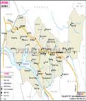
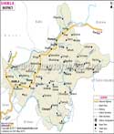
Out here, running a place so big means details matter more than ever. Kangra splits itself into smaller zones because leadership works better when it's nearby. Not far from the main offices, decisions take shape where people live, not just on paper. Each patch answers to leaders who know the roads, rivers, and routines. Distance fades when authority walks the same paths as everyone else. Local beats broad every time when trust depends on presence. No layer too thick, no gap too wide - just structure that bends close. 21 Tehsils make up the region - Dharamshala leads the list, followed by Kangra. Palampur comes next, then Nurpur slips in quietly. Dehra appears after that, Baijnath follows without delay. Jawali shows up mid-list, while Indora tags along nearby. Shahpur rests between them, Fatehpur pops up soon after. Jaisinghpur joins the flow, Khundian trails close behind. Jaswan enters the sequence, Baroh steps in right after. Rakkar fits into place, Sullah settles just beyond. Nagrota Bagwan stands out slightly, Bhawarna moves in smoothly. Dheera holds its spot, Thural fills another gap. Panchrukhi ends the lineup. That’s 3,908 revenue villages - more than any other district in Himachal Pradesh, making Kangra stand out by count alone.
| Official Name | Kangra |
| Location | Himachal Pradesh |
| Area | 5739 sq. km |
| Population | 1510075 (2011 census) |
| Language | Pahari (Kangri), Punjabi, Hindi |
FAQs
Q1: How many villages are there in the Kangra district?
Among all districts in Himachal Pradesh, Kangra stands out because it holds more villages than any other - exactly 3,908. That count makes it the leader by village numbers in the state.
Q2: What is the Total Population of Kangra District?
Some official numbers show Kangra holds 1,510,075 people - this place packs more folks into its space than any other area across the region. Though quiet in parts, it stands out simply by how many live here. While others spread thin, this one stays tightly filled. Because of these tallies, it claims the top spot. Not far behind in size, none match its crowd.
Q3: What is the Kangra District Known For ?
Up high over the valley, Kangra pulls your gaze toward icy mountain tips cutting into clear sky. Sitting on a rocky edge, the ancient walls of Kangra Fort hold quiet memories older than written pages admit. Moving higher, McLeod Ganj breathes slowly - more than streets, it's where robed monks pass through alleys and cloth prayers wave in patient air. Beyond that stretch, Bir Billing spreads open fields where people soar on fabric wings, lifted by gusts like fledglings testing air. Elsewhere, past fog-draped ridges, tea .
Last Updated on : July 10, 2026