

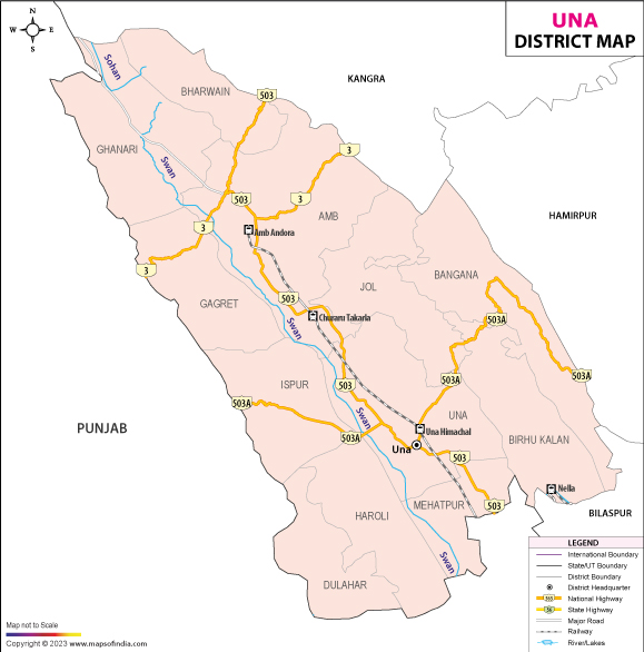





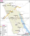
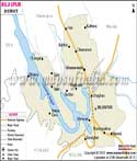
Certain districts reveal their characteristics gradually. The district of focus for the time being is Una, which feels like the opening scene of a thrilling novel at first glance—and yet holds a great deal under the surface to transport you through layers of history, culture, trade and travel. Una is a district that lies in the south-western portion of the state of Himachal Pradesh and is one of the main routes into the plains of Punjab. Looking at a Una district map, immediately identifies its strategic importance as a link corridor between the lower Himalayan region and the neighbouring plains region and as an important administrative and commercial link between the two.
The district of Una was reorganised from the erstwhile Kangra district on 1st Sept. 1972 and has been steadily growing as a prominent trade, industry and pilgrimage centre. Una has a landscape all by itself, the high mountain region of Himachal Pradesh combines rolling hills, fertile agricultural land, seasonal streams and growing towns, creating district that exists at the junction of two geographical worlds. The administration and economic focus of the district is Una town.
History & Culture
Una district's history is not confined to when it was established as a district in 1972. The area has been a part of the bigger region of the Kangra which is one of the most historically important regions of the western Himalayas for centuries. Overlapping trade route regions completed the ring of trade and local settlement areas grew up under the influence of many ruling dynasties.
The area had been under the domination of various Rajput rulers, local chieftains and larger Kings whose rise and fall brought change in the pattern of western Himalayan politics historically. In the medieval period, the authority of the rulers of the Kangra valleys spread to a large part of the present day Una district. This area was to be affected by the expansion of the Mughals, the influence of the Sikhs and later the British.
The identity of "Una" started to define its modern shape after Indian Independence. The region gradually changed with administrative reorganisation and developmental projects. Over the years, it has grown as one of the important districts of Himachal Pradesh with regard to connectivity, industry and religious tourism. On studying the Una district map, it becomes clear that the whole area would grow up to become a natural flow and trade belt between the states of Himachal Pradesh and Punjab.
Religious belief is at the heart of the lives of many people. At various temples, shrines and religious sites, thousands of devotees are drawn every year. Festivals like the celebration of Dussehra, Holi, Lohri, Diwali, Navratri, etc., take place with great enthusiasm throughout the district.
The Una district map not only depicts a cultural landscape in urban centres. Villages are still important sources for traditional practices, folk performances and local handicrafts. Farmwork routines and festive events during specific seasons and temple-based event celebrations still dictate the tempo of rural life.
Economy
The economy of the Una district is a dynamic mix of agriculture, industry and service with government assistance. The district has been able to develop itself as one of the most industrialized areas of Himachal Pradesh due to its favourable geographical location.
A substantial portion of the population is still engaged in agriculture. Other important crops grown in the district are wheat, maize, rice and a number of pulses. In many places, productivity has improved due to improved irrigation facilities and agricultural practices. The fertile areas shown on the Una district map are the areas where farming is still an important economic sector despite the industrialisation process.
Government Sector
The government sector is crucial for the economy of the district. Direct and indirect employment is provided in Administrative offices, Education, Health care, Law enforcement, and Development departments. District level government institutions significantly contribute to the economy and promote infrastructure development and public welfare programmes.
Roads, schools, health centres and rural development projects have been funded, leading to better standards of living in the district. The economy has also been supported by various government initiatives which include Agriculture, Skill Training and Livelihood Development in Rural areas.
Public Sector
In the public sector, support for infrastructure and investment promotion has been a significant contributor to the growth of the industries. The district has become a focus of manufacturing through the development of industrial estates and organised industrial areas. The strategic location of the place highlighted on the Una district map has enabled the industrial units to be able to reach the markets of Himachal and adjoining Punjab.
The manufacturing industry consists of pharmaceuticals, engineering products, electrical equipment, packaging materials, textiles and the food-processing industry. These areas have provided employment and work outside the farming use of the district, more as a diversified district's economy.
Industrial development has also promoted other businesses, transport and commercial activities, which have brought about a multiplier effect on the local economy.
Services Sector
Services as a sector have grown significantly in the past few decades. The district's income and employment generation is now recognised to be heavily dependent upon the banking industry, education, healthcare and retail trade, hospitality and transport and telecommunications.
Schools and universities draw students from nearby areas, and medical care institutes provide medical facilities to people from both the surrounding areas and neighbouring regions. Another significant development is the rise in the number of pilgrims and tourists in the district, leading to the prominence of tourism-related activities.
Commercial activity is flourishing in Una town and other urban centres. The Una district map caters to the requirement of highlighting the role of the district as a transport and logistics hub for providing support to trade traffic to and from Punjab and Himachal Pradesh. The majority of the retail trade, wholesale trade and service enterprises exist and are expanding along with increasing urbanisation.
Tourism
The tourism in the district of Una is a blend of spirituality, nature and culture. Although the district has no snow capped peaks like other parts of Himachal, it has a lot of other attractions as well that make any year a tourist friendly one.
One of the most frequented places is the hallowed abode of Maa Chintpurni Temple, one of the important Shakti Peeths of the northern part of the country. From different parts of India, devotees visit to take blessings, particularly during the festivals of Navratri. The atmosphere of the shrine is spiritual, which gives a great experience to the pilgrims. The town is also a popular tourist spot for those interested in Sikhism and local customs, particularly for a visit to Dera Baba Bharbhag Singh, a key religious centre of the community. Here, there are yearly congregations of followers and visitors in considerable numbers.
The Una district map also highlights the countryside views, which will bring out the quieter part of the district. Looking out towards faraway hills, small streams and rural settlements give them a rustic feel to the scene, different from the bustling and more touristy parts of the state. Further, the local pilgrimage centres, along with several village shrines, add to the legacy of religious tourism. They have different legends, traditions and architectural features at each destination.
The Una district map is popular with nature lovers, as it shows some additional countryside with gentle hills and woodland. In the monsoon season, the countryside undergoes a dramatic change-the green prevails in vast tracts of the district.
Another great benefit is the fact that the district is accessible. The visitors coming from other parts of Punjab, Chandigarh, etc. can easily reach here by well connected roads as well as Railway services. This connectivity has been a significant factor in the gradual development of tourism, as shown in the Una district map.
Apart from the popular tourist attractions, the district provides a chance to immerse in local culture, experience traditional food and hospitality of the rural areas. The Una district map serves as a worthy testament to a place of remarkable harmony between spirituality, history and daily life; for pilgrims, travellers and cultural fans.
Demographics
The 2011 population of the district of Una, according to the Census of India, was 521,173. The literacy rate of the district was 86.53%, which is the status achieved by some of the more literate districts in the state of HP.
The population includes urban and rural areas, with the majority from villages. One can see a linear increase in social development indicators with the development of education, healthcare, infrastructure, etc. The demographic trends discerned in the Una district map reveal the traditional rural settlements as well as the development of urban centres.
Una's identity is shaped by language in other ways, too. The district is primarily Hindi speaking and as a result of its close proximity and ethnic diversity to the Punjab, there is a large Punjabi speaking population. There are also a variety of pahari dialects that are also spoken in the rural areas, which provides a rich language environment.
The district has had slight population increases over the past decades and a relatively stable community make up. For modern-day Una, education has helped to build the skills of the citizenry in reading and writing and has helped to improve the community and economy.
Administration
Efficiency for administration is one of the characteristics of the district of Una. Main administrative functions are coordinated from the district headquarters located at Una town.
The district, according to the Census 2011 administrative divisions, is divided into the tehsils of Una, Amb, Bangana, Haroli and Bharwain. The Una district map shows the distribution of all the tehsils over a varied scenario, including urban areas, hilly areas and agricultural areas. Local governance functions are through panchayats and municipal bodies and district level institutions to provide public services.
The district has 848 villages, which are the core of the rural economy and cultural assets thereof. All these villages are diverse in size, geographical location and economic functions, but are important in making up the agricultural output, culture and society of the district.
The district has a number of administrative departments coordinating the development planning, infrastructure expansion and welfare implementation. The organisational framework identified on the Una district map will take into consideration both rural and urban development initiatives.
FAQs
Q1: How many villages are there in Una district?
Una district has 848 villages according to Census 2011 records.
Q2: What is the population of Una district?
According to the Census of India 2011, Una district has a population of 521,173.
Q3: What is Una district famous for?
Una district is famous for the Chintpurni Temple, its strategic gateway location between Himachal Pradesh and Punjab, and its growing industrial and commercial importance.
Last Updated on : July 10, 2026
