Hamirpur is situated between 250 7' N -260 7' North Latitude and 790 17' E-800 21' East Longitude.
The district of Hamirpur covers an area of 4,121.9 sq. km.
The total population of Hamirpur is 4, 12, 009 according to the census of 2001. Among which 1,95,971
are male and 2,16,038 are female.
The economy of Hamirpur depends mainly on agriculture. The main crops are wheat, rice, barley etc. Horticulture is also practiced in this district.
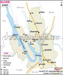
Hamirpur District Map |
|
||||||||||
| ||||||||||
|





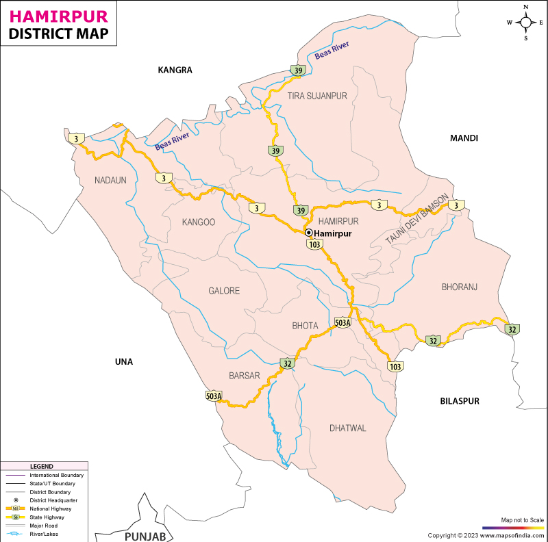
| *Map showing National Highway, Major Roads, District Headquarters, Major Towns, Rivers and etc in Hamirpur District. |
| Major Districts of Himachal Pradesh |
 |
 |
 |
 |
| Kangra District Map | Kullu District Map | Mandi District Map | Chamba District Map |
 |
 |
 |
 |
| Shimla District Map | Solan District Map | Una District Map | Bilaspur District Map |
| other districts of Himachal Pradesh >> | |||
Clinging to the foothills of the scenic Himalayan ranges, the district of Hamirpur in the state of Himachal Pradesh spells out a land full of divine stories and experiences. Though small, it is a very influential area without any doubt, given its spiritual and scenic significance. It is located strategically in the lower Himalayan region and surrounded by some known districts such as Kangra, Mandi, Bilaspur and Una. The headquarters of the district is Hamirpur city - a vibrant administrative and educational centre, which has been evolving continuosly to become one of the most dynamic urban settlements in the state over the years.
The influence of a historic past is reflected in the rolling hills today, and a sense of history and modernity is palpable throughout. From the Hamirpur district map it is seen that the district is small in area and the land is undulating with some seasonal streams and fertile valleys covering nearly 1,118 sq. km of area. The Hamirpur district map also shows that it sits between the Beas and Sutlej rivers which is advantageous.
Hamirpur, unlike many other Himalayan districts, which are renowned just for their tourism, is well recognized for education, military service and high literacy. In terms of literacy it is one of the best and most consistent performing districts in HP. An overview of the road network across the Hamirpur district is also depicted on the Hamirpur district map, ranking the district as being well connected with villages, nearby towns/tehsils and other adjoining districts.
History & Culture
Hamirpur district's history goes way back in the historical fold of the western Himalayas. Throughout centuries it became a part of the land holdings of powerful Katoch rulers, some of the oldest royal houses of India to survive. The district received its name being respectfully named after Raja Hamir Chand of the Katoch dynasty, who vastly bolstered political power in the region. His fort was an important administrative and defence point and is the bedrock of present day modern Hamirpur.
But the hills were already the site of States and shifting alliances, local battles and different spheres of influence. The British administration imposed a new administrative structure, resulting in a change in the ways the region was governed, and over time, the region became linked to roads and communication networks. A Hamirpur district map provides a clear picture of the changes in settlement patterns and regional integration in the area due to administrative changes.
After Independence the district became a part of the State of H.P and had registered considerable growth. Educational institutions expanded. Government services improved. The roads gradually extended to the distant villages. The Hamirpur district map shows a slow change depicting an integrated and vibrant district.
Culture at Hamirpur is much ingrained with Himachali traditions. Folk songs, dances and oral histories remain important to hold onto memories of historical events, heroes and community values. At festivals and social events, there are still elements of traditional dress around, while local crafts continue to illustrate the artistic roots of the hill communities.
The district experiences tremendous vigour at festivals that the towns and villages celebrate with excitement for festivals, such as the Festival of 'Dussehra', 'Diwali', 'Holi' and 'Lohri'. Small townships can become a lively hub for the practice and commerce of religion with religious fairs held in connection with local temples. Many pilgrims go from several holy sites in the district to Hamirpur and the route between two holy sites is guided by the Hamirpur district map.
The district also has a great heritage in the Military sector. Many families have contributed to the Indian Armed Forces and this is what establishes this culture of discipline, patriotism, and service in the public interest. This bequeaths a valuable social legacy to the district.
In addition to the cultural mix, there is language as well. In addition to Hindi, various Pahari dialects are widely used, and a number of geographical and historical influences of Punjabi can be seen as well. This linguistic/cultural exchange is illustrated with the Hamirpur district map which can be helpful to draw any references.
Rather, Hamirpur's cultural scene is a reflection of many centuries and numerous stories, of communities and the environment's interactions and interactions with one another.
Economy
The Hamirpur district is relatively more diversified and balanced economy than most of the hill districts. Agriculture continues to play a significant role but education and government-related activities and services play a growing role.
Governments are of pivotal importance in the district's economy. The government employs a large part of the population, as do educational institutes, administrative departments and public services. Institutional head offices of the district are important governance centres providing opportunities in education and public administration.
The Public Sector contributes in the areas of infrastructure development, public works, utilities and welfare programmes. District infrastructure – including roads, health facilities, educational institutions and rural development projects – has provided a firm footing for economic development across the district. A Hamirpur district map can be helpful to analyse how this region has been benefiting from the growth of connectivity and its enabling effect on economic and social development.
Although access to land is limited because of the topography in the district, agriculture is still considered a crucial means of subsistence. Wheat, maize, paddy and pulses are grown by the farmers, with horticulture gaining importance in suitable areas. Livestock rearing has an additional benefit for the household in terms of income and also to the rural economy. The Hamirpur district map is useful in the identification of fertile valleys and agricultural areas that support these activities.
The district has developed the Services Sector as one of its good performers in the district economy. Teaching, administering and supporting children in an educational setting, as well as working in health, banking, retail trade and transportation. The city of Hamirpur has established a great reputation as a hub of education and as a result, students from across the country are travelling to the city, thereby creating demand for ample room, food services and other businesses.
Local businesses, markets and trading as well also foster economic vitality. The construction sector, transportation services and communication services have been growing steadily with the strengthening of infrastructure development. In a way, these economic connections have been captured in the Hamirpur district map where many roads link the towns and villages.
Earnings from remittances of military, government personnel and professionals outside the district are another important income source for the households. This money inflow finances property development and education for the region, while allowing its citizens to purchase the goods of the region and beyond.
Tourism
While some destinations in the Himalayas are in the spotlight, tourism in Hamirpur district is not as well-known; it certainly possesses a mix of history, spirituality and scenic beauty.
However, Sujanpur Tira is one of the most renowned places in the district. The town was built by Raja Sansar Chand, and has historical temples, remains of palaces and open spaces related to traditional fairs. Katoch rulers' artistic achievements are evident in their architectural legacy in the area.
The Awah Devi Temple is another important religious site that is of significance. It is situated on a hillside and so provides a spiritual significance in addition to an extensive view of the countryside. People come to the site all year round, especially for important religious festivals. The Hamirpur district map is a useful guide to help pilgrims navigate to this sacred place.
The Tauni Devi Temple is visited for religious reasons and for its picturesque setting. The hills around the building brighten the spiritual scene, making the visit memorable.
Nadaun is a pleasant combination of nature and history which is also at the banks of the Beas River. It has memorable historical events in the town's past and a tranquil riverside vista. The lustrous nature continues to be one of Hamirpur's greatest attractions. Quaint rolling hills, green valleys and wide-angle perspectives make for leisurely exploration.
Demographics
As per the Census of India 2011 Hamirpur district population is 454,768. Overall literacy rate of the district was amongst the highest in the state of Himachal Pradesh, underlining the importance it places on education. The population live in urban and mainly rural settlements.
Literacy rate of Hamirpur district is 88.15 per cent which is one of the highest among the districts of the state. For years, the district has typically been characterized by its high levels of educational achievement.
The official language is Hindi and it is widely used in administration and education. There are several dialects in the district, with the regional dialect being commonly understood, with both Punjabi and Urdu being understood in various places with historical and geographical connections.
The demographic profile reflects an essentially rural population with a high level of educational achievements, a measure of balanced development and high participation that is found in the community. A Hamirpur district map helps illustrate the distribution of population centres amongst the hills and valleys of the District.
Administration
From an administrative point of view, Hamirpur district is divided into tehsils, which are used to perform administrative and service functions. There are 7 tehsils which include Hamirpur, Barsar, Bhoranj, Nadaun, Sujanpur Tira, Galore and Dhatwal. They are administrative areas to aid in the governance of local development and collection of revenues, and the provision of public services.
The district has about 517 villages in the rural settlement pattern, which is the backbone of the district. The village sizes and densities are quite heterogeneous, but are the social, cultural and economic pillars of the district. A Hamirpur district map gives an overall picture of the dispersion of settlements.
District administrative institutions act as a link between the government and sub-divisional/village administrative institutions, carrying out administrative work on behalf of the government, preserving infrastructure and assisting local development measures. The map of Hamirpur district remains an irreplaceable administrative tool in planning, administration, and management of the resources.
FAQs
Q1: How many villages are there in Hamirpur district?
Hamirpur district has approximately 517 inhabited villages.
Q2: What is the population of Hamirpur district?
According to the Census of India 2011, the population of Hamirpur district was 454,768.
Q3: What is the district of Hamirpur famous for?
Hamirpur district is famous for its exceptionally high literacy rate, strong tradition of military service, educational institutions, historic heritage and important religious sites such as Deotsidh and Sujanpur Tira.
Last Updated on : July 10, 2026
