






About
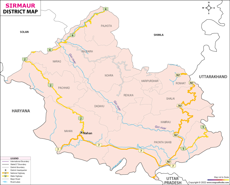
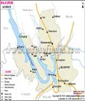
Sirmaur lies in southeast Himachal Pradesh. It is shaped by gentle elevation shifts. Forested slopes are found here that belong to the Shivalik range and lower Himalayan fringes. Sometimes referred to as an entry point to hill terrain, its location bridges distinct geographic zones. To the north stretches Shimla; Solan appears on the northwestern edge. On two sides - east and south - it meets regions now part of Uttarakhand and Haryana. Sitting at this crossroads, its hills have long held traces of both valley lifestyles and highland customs. Elevation changes slowly, yet cultural overlap runs deep across communities.
Across its 2,825 square kilometers, terrain shifts dramatically - split cleanly by the Giri River slicing through the center. South and west of that waterway lies Cis-Giri. Northward and eastward, beyond the river’s reach, Trans-Giri rises sharply - rocky peaks claw at clouds, narrow ravines cut deep, settlements cling to cliff edges without apology. On one high ridge rests Nahan, a quiet town shaped during colonial years, now managing affairs for land thick with crops, factories humming below, traditions carved into every slope. Size remains fixed; change lives only in form.
History & Culture
Gently rising ground defines Sirmaur, positioned in southeastern Himachal Pradesh. Though close to the level of the northern lowlands, the land slowly lifts into wooded inclines - part of the Shivaliks and outer Himalayas. Often seen as a threshold to hilly areas, it links distinct physical landscapes. Northward lies Shimla; Solan sits toward the northwest corner.
High above the valley floor, across 2,825 square kilometers, land folds and fractures along natural lines. A sharp divide emerges where the Giri River cuts straight through the middle ground. To the south and west of this flow spreads Cis-Giri - hills dip gently under open air, fields patch areas such as Paonta Valley, and daily rhythms move without rush. Once past the river toward north and east, Trans-Giri juts upward abruptly - stone summits tear into fog, thin gorges slice downward, homes perch on steep drop-offs with firm resolve.
Perched on one elevated edge stands Nahan, a subdued settlement formed in imperial times, today overseeing territory dense with harvests, machinery murmuring in lower zones, customs etched into each incline. Distance stays constant; transformation occurs solely in shape.
Economy
Fruit and vegetable cultivation thrives here alongside major industrial zones, shaping Sirmaur’s distinct economic profile. Industrial activity grows steadily, supported by fertile agricultural output across the region.
Government Sector
Employment anchored in public service shapes livelihoods throughout the region, offering stability to many households. Running alongside daily governance, departments such as civil administration, local courts, forestry, and city councils sustain large workforces through structured positions. Given that Sirmaur borders both Uttarakhand and Haryana, agencies managing liquor regulation, cross-border logistics, and highway coordination operate at elevated intensity. On top of this, spending on education hubs - including the government medical college in Nahan and several undergraduate institutes - fuels job continuity while sharpening local workforce capability.
Public Sector
Heavy utility systems across the district fall under government oversight, ensuring consistent connectivity and energy flow. Along the Giri and Yamuna river paths, state-run power bodies operate several small-scale hydropower sites feeding both households and industrial areas with electricity. When rains pour without pause, road and bridge upkeep becomes a demanding job - managed by civil engineering units trained for extreme weather conditions. In agricultural regions like Paonta Valley, water delivery relies on an intricate series of canals maintained by irrigation specialists throughout growing cycles.
Services Sector
Years of rising factory earnings have fed expansion across service-based businesses. Alongside property projects, pilgrim visits, and nature-focused travel keep momentum high. Credit flows easily because banks operate widely, serving entrepreneurs who run production units or sell fruit in bulk. Some lenders also back new guesthouses opening near scenic spots. Movement of cargo defines one critical arm of this economy - trucks never stop rolling outwards from loading zones. Each day brings outbound shipments: medicines sealed in boxes, packaged snacks, just-harvested crops. Destinations stretch far, reaching key hubs like Delhi and Chandigarh regularly.
A number of factories are located in the district of Sirmaur. Kala Amb and Paonta Sahib are the two places that host a large number of factories. Ranging from medicine to fabrics, from plastic items to vehicle assembly parts, one can find a diverse factory set up in Sirmaur. Manufacturing here spans multiple sectors, including everyday household products. Each unit adds to a landscape shaped by steady production rather than flashy promises.
Tourism
High up beyond the busy streets of Shimla, Sirmaur unfolds quietly - home to still alpine lakes that mirror the sky. Peace arrives through winding forest paths leading to ancient temples tucked among pines. Life thrives in protected green spaces where birds call from dense canopies overhead. Fewer footsteps pass here, leaving space for slower discoveries beneath towering hills.
Renuka Ji Lake
Renuka Lake lies roughly 38 kilometers away from Nahan, standing as the biggest natural body of water in Himachal Pradesh. It is rich both ecologically and culturally. While mostly quiet, the area shelters wild animals within a protected zone, along with a space where lions roam under careful observation. Because the surface rarely ripples, visitors often glide across it quietly in boats, drawn to the stillness. Scattered near the shore, old stone shrines honor Goddess Renuka alongside Lord Parshuram, her son, turning the site into one where belief meets landscape without effort.
Paonta Sahib Gurudwara
Paonta Sahib Gurudwara is located at the boundary of Himachal Pradesh and Uttarakhand. It is situated along the Yamuna River. It remains a popular tourist spot not just for the Sikhs but for everyone visiting the district. Guru Gobind Singh Ji spent key years of his early life at this place. During his stay, significant religious writings took shape, while military strength began to form under his guidance. Inside the grounds, visitors find an expansive shared dining hall serving meals daily, galleries filled with old weaponry telling stories of past eras, and then a quiet path by the river - where voices rise in sacred song carried gently across currents.
Suketi Fossil Park
In the Markanda Valley of Sirmaur lies Suketi Fossil Park, notable for its worldwide scientific value. Built precisely where ancient fossils emerged, it became Asia's pioneer site of its kind. Life-sized replicas made of fiberglass depict creatures once present in the Shivalik region - long before modern times. Among them stand massive tortoises, felines with blade-like teeth, and elephant ancestors now vanished. Though quiet today, the area draws school outings, relatives exploring together, and those curious about deep time. Learning happens quietly here, through sight, scale, and silent figures in the open air.
Demographics
Sirmaur district hosts a steadily rising community where compact urban zones blend quietly beside age-old hillside settlements. Official data from the 2011 Census shows the area is home to exactly 529,855 individuals. Among them, men make up 276,289 persons; women number 253,566. For every thousand males, there are 918 females - a figure sitting near typical patterns seen throughout the lesser Himalayas. Most inhabitants stay rooted in countryside life: nearly 89 percent live scattered through farming clusters and remote highland villages. Town dwellers form just about one out of nine residents, clustered mainly within key commercial or government centers. Despite shifts, the land holds firm to its rural character.
Despite progress, disparities linger in Sirmaur district's learning outcomes. Literacy there reaches 78.80%, shaped by persistent efforts in schooling over the years. Boys show higher rates - 85.61% able to read and write. In contrast, girls stand at 71.36%. Efforts over the past ten years mix government plans, local initiatives for girls’ attendance, and funding from corporate social responsibility pools - all aimed at slowly closing that space between figures.
Though less widespread, English finds its place within tourism hubs and business zones. Spoken most often at home and in village gatherings, Sirmauri carries stories through generations. Administration runs on Hindi - found in classrooms, offices, and public notices.
Administration
Across its administrative structure, Sirmaur district belongs to the Shimla division within Himachal Pradesh. Oversight of civil affairs, monitoring of land records, along with implementation of social services, rests primarily with the Deputy Commissioner - also serving as District Magistrate - who operates hand in glove with the local police chief. This coordination ensures stability, reaching into villages just as much as towns.
Across the varied terrain of Sirmaur, nine tehsils shape how services reach people. Where valleys create separation, these divisions help manage tax gathering more smoothly. A different official leads each area - called a Tehsildar - who oversees daily administration. These roles exist not just for structure but to bridge gaps between the government and residents.
Centered around its old capital, Nahan Tehsil holds key government offices alongside judicial facilities and primary healthcare centers. Though known for governance, it maintains a quiet presence amid administrative functions. Located strategically, the area supports legal operations through district-level courts. Healthcare access comes via major public hospitals serving local needs. Governance here blends tradition with daily civic management. The region operates without fanfare yet remains essential to regional oversight.
Most of Sirmaur's area lies in its countryside - about 968 revenue villages, grouped into various gram panchayats. Governed democratically through the Panchayati Raj setup, each unit elects a local council headed by a leader known as the Pradhan. Owing to rugged terrain where dwellings cling to sharp slopes and swift rivers cut off access, such local bodies become vital. Oversight of age-old irrigation routes, called kuhls, falls to them; so does safeguarding shared woodland areas. Education at the grassroots level functions because they run elementary schools. Paths used for foot travel across hills stay passable due to their upkeep efforts. Access to medical support and work opportunities within remote households depends largely on these institutions.
| Official Name | Sirmaur |
| Location | Himachal Pradesh |
| Area | 2,24,759 hect. |
| Population | 5,29,855 |
| Language | Hindi |
FAQs
Q1: How many gram panchayats are there in Sirmaur?
There are 259 Gram Panchayats in the district.
Q2: What is the population of the district?
The population of the district, according to the 2011 census, is 529855.
Q3: What is the district famous for?
Among India’s northern regions, Sirmaur stands out due to vast peach and ginger farms that supply markets worldwide. Known less for cities than for landscape, it holds Renuka Lake - a site many visit for quiet reflection. Perched nearby, the Paonta Sahib Gurudwara carries deep historical weight through its architecture and community presence.
Last Updated on : August 21, 2026
