






About
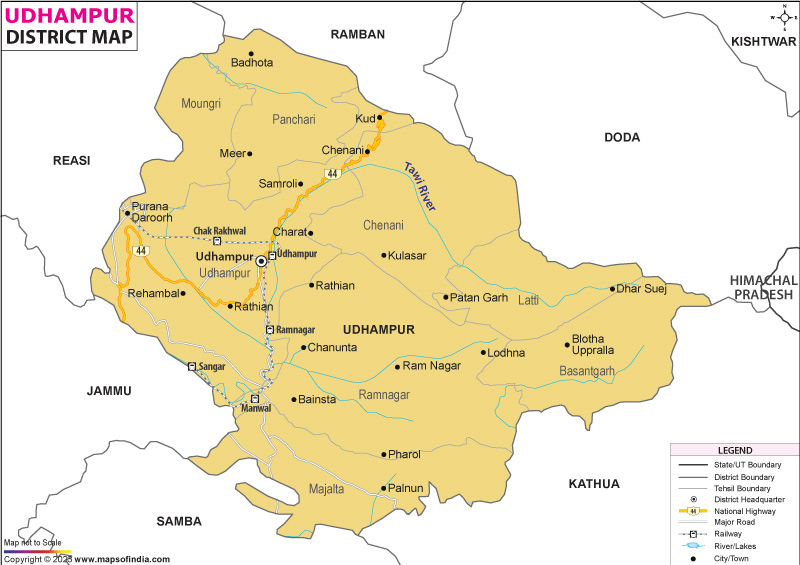
Situated in the southeast of Jammu division within Jammu and Kashmir, Udhampur district carries layers of history, varied terrain, and strategic importance. Known widely as the "Land of Devika," it draws the name from a sacred river running through its center. While serving as a key passage, the area links culturally distinct zones - the flatlands near Jammu on one hand, the remote mountainous stretches of Kashmir and Ladakh on the other. To its north and west lie Ramban and Reasi; nearby to the southwest stretch Jammu and Samba. On southern and eastern edges sit Kathua and Doda. Because of this layout, elevation shifts sharply here - where warm lowland climates give way without warning to steep alpine ridges marking the start of high Himalayan ranges.
History & Culture
Udhampur’s past unfolds through shifting realms - Dogra chieftains ruling small mountain territories, remnants of old settlements, and calculated troop movements across rugged terrain. Named for Raja Udham Singh, it took shape when he chose a broad stretch of sandstone to build what would become today’s town. This ruler, firstborn of Maharaja Gulab Singh, helped form the larger Jammu and Kashmir state during turbulent times. His efforts in the 1800s slowly shifted influence away from earlier strongholds such as Chenani’s court and Babore’s fortified posts. Centuries prior, long before Dogra authority emerged, the area thrived spiritually and politically under Dev monarchs. Their legacy survives in stone - the Krimchi temples dating back to the 700s - a cluster often tied by oral tales to the Pandavas’ wandering years described in epic lore.
Deep within the folds of the northern landscape, Udhampur’s identity flows from broader Jammu roots, molded by mountain terrain and time. Life here pulses quietly to the beat of Pahari ways across much of the area. Yet closer to flatlands and gentle slopes, a different rhythm appears. There, customs tilt gradually toward Dogra patterns instead.
Warmth between neighbors defines life here. During festivals - Lohri, Maha Shivratri, Holi, Eid-ul-Fitr, Baisakhi - the same joy spreads through each village, rooted in shared regard. When people meet, Dogri and Pahari songs rise without effort, season after season. Old ways move forward simply, carried by rhythm and motion.
Nowhere else does tradition breathe quite like here, where mountain tales shape daily rhythm. Instead of books or archives, elders called Gards or Yatrs pass down memory through voice - singing Bars that recall Dogra courage, along with Karkans praising gods tied to land and weather. During festivals, crowds form in open clearings, drawn by the pulse of drums guiding the Kud dance: feet strike ground in unison near flames, an offering of gratitude to Devtas watching over fields and herds.
Each April, the Devika River becomes a center of movement and prayer when Baisakhi Mela unfolds across three days; pilgrims arrive in waves, stepping into waters believed in to the Ganges, seeking nothing spoken but felt. Elsewhere in the year, places such as Sudhmahadev and Moungri stir again with color and noise - wrestlers clash under open skies while singers echo ancient lines, shared meals served freely beneath cloth tents stitched by many hands.
Economy
Deep within its structure, Udhampur's economy thrives on more than just one foundation. Heavily shaped by defense presence, it also leans on government operations as key support beams. Major construction efforts across the region add another steady push forward. Meanwhile, farming that targets premium markets finds success in elevated terrain, contributing meaningfully below the surface.
Public Sector
What shapes Udhampur’s role on the national map is large-scale infrastructure built through sustained public investment. State and federal agencies oversee ongoing upgrades to NH 44, along with progress on the high-profile rail connection linking Udhampur to Baramulla via Srinagar. Behind these efforts runs a steady demand for skilled locals - engineers, equipment handlers, logistics coordinators - who keep operations moving. Meanwhile, water delivery in rugged upland areas depends on systems maintained by public works and irrigation units, bringing essential service to isolated villages through gravity-based distribution.
Services Sector
Years of rising defense investment have shaped much of what drives service expansion today. Driven not just by military needs but also by movement across states, trade flows steadily through this region. A growing number of travelers choosing local landscapes has lifted tourism's role in recent times. Financial services stretch wide, their offices serving soldiers, freight firms, and guesthouse owners alike. Instead of clustering only in cities, banks reach into remote stops where transport workers pause.
Tourism
Up in the highlands, Udhampur waits quietly for those drawn to quiet discovery. Far from routine, it offers sharp winds and old stones whispering stories no one fully knows. Hidden among leafy slopes stand weathered temples, silent as if grown from rock itself. Not simply sites of worship or relics of years gone by - these places linger inside you without warning. Long after footsteps fade, something remains.
Patnitop
High above at more than two thousand meters, Patnitop rests across a broad, quiet flatland near the primary road. Towering woods filled with dense deodar and pine wrap around it, giving a storybook kind of feel. When winter arrives, snow drapes heavily over every surface, soft and deep. Cool, fresh breezes move through during warmer months, keeping temperatures gentle.
Here, many simply prefer relaxing - few things match a calm stroll under pines inside the Nature Park. Yet for those seeking energy, alternatives exist: paragliding floats you above ground, while zip-lines add speed. Above all stands the Skyview Gondola, gliding noiselessly overhead. From its cabins, sightlines open wide - to layered green slopes folding into distant hills.
Sudhmahadev and Mantalai
Deep within the scenic Chenani valley lies Sudhmahadev, home to a sacred Shiva temple nearly three millennia old. This holy place holds an enormous ancient iron trident - linked through legend to Lord Shiva himself - not preserved merely as a relic but embedded in living belief. Traveling beyond by road brings you to Mantalai, cradled among dense groves of deodar trees, its high-altitude meadows glowing under open skies.
Krimchi Temple Complex
Tucked away in a quiet valley just under twelve kilometers from Udhampur, these seven stone shrines rise like echoes of an older time. Known locally as the Pandava Temples, their roots stretch into the 8th or possibly 9th century AD. Instead of modern noise, what meets visitors is silence - broken only by wind tracing through carved pillars. Each structure follows the early Nagara design, where tall spires climb skyward, marked by precise geometric patterns. Rather than flashy ornamentation, restraint defines them: broad platforms, open courtyards, forms shaped with care.
Ramnagar Fort and Palace
Besides drawing those keen on legacy and the past, Ramnagar holds a vast palace-fortress reflecting the design mastery of former Dogra leadership. Constructed during the 1800s under Raja Suchet Singh, its fort rises with thick stone walls, purpose-built watchtowers, along with a protective water ditch meant to resist prolonged attacks. Close by stands the elegant Sheesh Mahal - known widely for dazzling painted murals inside - portraying detailed moments from the ancient epics Ramayana and Mahabharata through bright plant-based pigments.
Demographics
Looking closer at Udhampur district, numbers show a steady rise in residents who are well-educated and share strong cultural ties, spread between active transport centers and remote highland communities. Official data from the 2011 Census reports the overall count at 554,985 individuals. Of these, men make up 296,784 persons; women form 258,201 - resulting in 870 females per 1,000 males. It's shaped largely by long-term deployment of male-dominated defense units along with workers moving through national road networks. Most inhabitants still live outside cities: close to four out of five occupy farming clusters and elevated enclaves. Urban pockets such as Udhampur City or Ramnagar house roughly one-fifth of the populace.
Among India’s districts, Udhampur shows progress - its literacy rate sits at 68.49%, shaped by years of steady investment in schooling systems. Not every group shares that gain equally; males reach 78.36% literacy, while females trail behind at 57.10%. Progress has roots beyond government efforts - since the past ten years, military-supported Goodwill schools have operated quietly alongside community projects aimed at girls in remote areas. These combined actions slowly shift outcomes, narrowing what was once a wider divide.
Across homes, songs, and street trade, Dogri pulses through the area as the everyday tongue. Though office work, government messages, and classroom teaching rely mainly on Hindi and Urdu, it is in shops, army posts, and universities where English gains ground. Most people follow Hindu beliefs - nearly nine out of ten. After that comes Islam, held by more than one in ten. Smaller still is the Sikh presence, long rooted in city centers tied to governance.
Administration
Udhampur district falls under the administrative umbrella of the Jammu division within Jammu and Kashmir. Oversight of civilian administration, management of land records, along with delivery of social services, rests primarily with the Deputy Commissioner - also serving as District Magistrate - who operates alongside the Superintendent of Police. Cooperation between these two offices ensures stability, whether along heavily traveled highway corridors or in isolated highland regions.
Split into eight parts, Udhampur district uses separate tehsils to manage public services and tax collection across valleys. Each unit operates under a local officer called a Tehsildar. Terrain differences shape how areas are run. Administration adapts where land divides communities. Eight zones follow this model. Local leadership handles daily tasks. Revenue systems stay active through these divisions. Delivery improves when regions act close to people.
Bordered by forested hills, Ramnagar Tehsil holds deep historical roots across wide countryside stretches. Governance here extends through remote agricultural pockets alongside ancient landmarks of regional importance. Villages dot the landscape, each tied to traditions shaped over generations. Heritage structures stand amid shifting terrain, reflecting layers of past influence. Administration functions quietly beneath a legacy both enduring and visible.
Latti-Marothi Tehsil rises where steep slopes meet sky, holding villages far from roads. Its peaks guard thick woods that stretch without break. Though cut off by terrain, life persists in small clearings among stone and pine. Weather shifts fast here - cold winds follow brief summer light. Few paths wind through; those who live there know silence best.
| Official Name | Udhampur |
| Location | Jammu and Kashmir |
| Area | 2380 sq. km |
| Population | 557689 |
| Language | Dogri |
FAQs
Q1: How many villages are there in Udhampur district?
There are 357 villages in the district.
Q2: What is the population of the district?
557689 people live in the district according to the 2011 census.
Q3: What is the district of Udhampur most famous for?
Perched high among pine-clad slopes, Udhampur draws visitors to Patnitop’s snowy woodlands. Standing quietly since the 8th century, the weathered stones of Krimchi’s old temples tell layered histories. Known widely by the name “Land of Devika,” it carries weight in spiritual tradition. Home to the Indian Army’s Northern Command HQ, its role in national defense shapes much of its modern identity. Not far from military posts, villagers craft Kaladi - a firm, golden-brown cheese fried until crisp at the edges. Rooted in terrain and taste alike, the area balances quiet heritage with strategic presence.
Last Updated on : July 21, 2026
