






About
A frontier land. A district that was formed by history, religion, trade and strategically placed location. Samba district is an important administrative/economic district of the Jammu division in the UT Jammu & Kashmir. Most of the map of the district Samba apparently shows areas of rich fertile plains, bustling towns, sacred religious sites, and growing industrial areas, and thus an important gateway to Jammu and Kashmir.
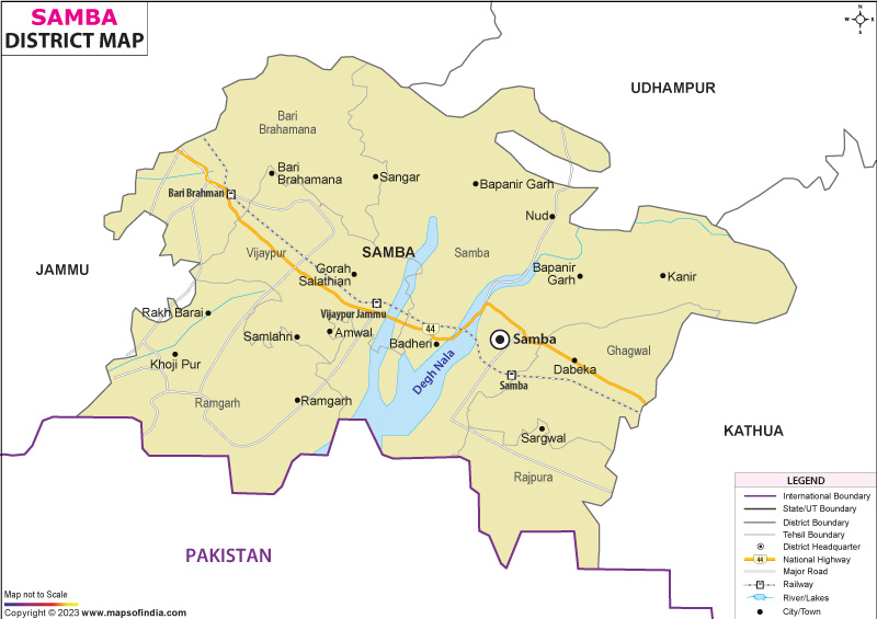
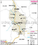
Once part of the erstwhile Jammu district, the city of Samba has emerged as a centre of development and connectivity in just a few years. The western edge of the district borders the international border while it simlutaneously borders the districts of Jammu, Kathua and Udhampur with the eastern, southern and north borders, respectively. From the study of the map of the district on the Samba district, it is observed that the district is connected with Jammu, which is an administrative/economic hub and the district is also connected with the major transportation cum commercial hub of Samba.
Although it is a relatively new administrative unit, Samba has a much older historical face. Ancient settlements, revered pilgrimage sites and remnants of princely-era influence continue to shape its cultural landscape. The Samba district map also indicates that the district has a strategic location and this has played a key role in the economic development of the district, industrial growth and defence importance.
In present times, Samba is a fusion of tradition and modernity. Old temples are not far from industrial estates. The growing urban centres are in close proximity to rural villages. The Samba district map is not just a geographical reference, but a map that portrays a district where history, spirituality and economic aspiration meet.
History & Culture
The story of "Samba" can be compared to a historical drama with a series of centuries. Local traditions trace the history of the town of Samba to the Middle Ages since it was established in the 15th century. The region slowly, little by little, became a part of the princely kingdom of Jammu and Kashmir and in due course got influenced by Dogras.
This significance further went on to grow in the period of Dogra rule. Enhancement of the role of the area in the larger Jammu region through fortification and administrative settlements, as well as through trade routes. The Samba district map shows how its strategic location along key communication pathways enabled it to grow into a hub for regional interaction and governance.
Culture is an integral part of the Samba culture and deeply embedded in the Dogra culture. Dogri is reflected in the local life in terms of language, music, folklore and traditional practices. Village gatherings are filled with folk songs and colourful celebrations are arranged throughout the year. The village location in the Samba district map often leads visitors to villages where centuries-old cultural practice is still alive.
The festivals make a key contribution to the district's identity. The festivities are celebrated with great enthusiasm during the Holi festival, Baisakhi, Diwali, Navratri and Lohri. The religious fairs are visited by devotees from all over Jammu and Kashmir and neighbouring states. One of the most significant Cultural functions is the Rath Khardha Mela of Ghagwal.
The traditional dishes also convey the general Dogra food culture. Rajma, kaladi, ambal and other wheat-based dishes are still popular. In everyday life, there is a lot of hospitality, and the social cohesion of the district is evident.
Economy
Samba district is an interesting mix of agriculture, industry, government employment and service. The district has become one of the most economically vibrant zones in the Jammu region over the years. The Samba district map shows the interdependence of industrial areas and agriculture and the movement of people and goods.
A major proportion of the population is still earning their livelihood through agriculture. Wheat, Paddy, maize and vegetables are major crops cultivated in the District. Fertile plains and irrigation facilities allow agricultural activities, and livestock rearing is an additional livelihood activity in rural areas.
The government sector is an important economic contributor to the district. There are also good jobs in administrative offices, educational, health and security establishments. Defence-related services/govt agencies play a significant role in the local economy, especially in the new town of Samba, where it is strategically located near the international border.
There has also been an impact on the district from the Public Sector. Infrastructure and public utilities projects, coupled with government-facilitated development programmes, have enhanced connectivity and economic opportunities. The Samba district map shows the urbanisation and industrial development areas that have been promoted by public investment.
Industry is one of the robust economic blocks of the district. Samba district has developed one of the biggest industrial hubs in Jammu and Kashmir, namely, Bari Brahmana. Pharmaceutical, food processing and packaging, electrical goods and consumer product manufacturing units are located in the area. The industrial belt on the map of the Samba District illustrates how the district is becoming more of a contribution to regional manufacturing.
The Services Sector continues to keep on rising steadily. Banking, retail trade, measures including education, transportation, and measures for the hospitality and telecommunications sectors are doing better. Plans have been integrated to boost business development and strengthen the economic sustainability of the district, resulting from major highways being created that have led to commercial activities.
Tourism
Samba district tourism is a trip into spirituality, the heritage and natural beauty. Each place appears to have a tale to tell. The following is a very useful map of the district for the use of the traveller who wishes to make a map of the variety of attractions available within the district.
One of the most renowned places of religious importance in this district is Purmandal. It is one of the oldest centres of pilgrimage and is an apt name for the "Chhota Kashi of Jammu" since it is situated on the banks of the sacred Devak. It is a place of worship and mysticism that is frequented by pilgrims all year round. A sacred site which is spoken about in the Samba district map. Utterbehni is another significant place of religion.
The historic Samba Fort looks back into the history of the district. Although it is now a bit older and the influence of time has left its mark on the fort, the place still reminds people of the Dogra rule and the interstate power struggle. The old map of the district of Samba also has some historical significance for those who are interested in military history, as it shows the location of the fort.
Mansar Lake, near the district boundary, is a very popular place for nature lovers and pilgrims as well. The lake has scenic and religious value; it receives tourists from all the northern parts of India. Apart from being noted for its cultural features, Ghagwal is also known for the celebrated Rath Khardha Mela, which is celebrated in festival time periods. One can use the Samba district map to get around the many districts during these colourful festivities.
The rural and agricultural scenes allow the individual to explore the alternate faces of Jammu and Kashmir. The scenic routes drive through hamlets, which introduce a wealth of culture and nature. Exploring the Samba district map with staff and locals to discover the wide spectrum of experiences it has to offer, whether one is in the pursuit of spirituality, history or just for a quiet slice of tranquillity.
Demographics
The Census of India 2011 states that the population of the district of Samba is around 318,898. The district is one of the important population centres of the Jammu Division and has experienced a steady growth in the past decade. The map of the district of "Samba" shows a blend of rural settlements and growing urban populations.
The district's literacy level exceeds 81 per cent, with understanding that there has been marked achievement in this field of education and human development. The impact of educational institutions, district-wide, has been to help increase literacy and socio-economic conditions.
Dogri, being the main language spoken here, is a significant aspect of the local identity too. There are also communities that speak in Hindi, Punjabi and Urdu, as well as Gojri. The map of the Samba district shows a variety of languages spoken, indicative of the diversity of cultures and communities that have come together there over the years.
The population is largely rural, but the urbanisation process has increased in some places like Samba town, Vijaypur and the Bari Brahmana. This demographic transition remains a factor coming to influence the district's development course.
Administration
In 2006, the Samba district was separated from the Jammu district and made into an independent district. To date, it has expanded its administrative network to effectively deal with governance and public services.
It is presently divided into six principal Tehsils – Samba, Vijaypur, Ramgarh, Ghagwal, Rajpura and Bari Brahmana. They are administrative units that aid in issues of revenue collection, development planning and service provision throughout the district.
The Census 2011 records include about 381 villages inhabited in the Samba district and some urban settlements. This is seen in the distribution of the villages of the Samba District, as shown on the Samba district map.
The district is endowed with administrative offices, local and development department offices that support governance, infrastructure development and public welfare activities. District mapping is a basic administrative planning and resource management tool for the Samba district, and a map of this district is still in use.
FAQs
Q1: How many villages are there in the Samba district?
The Samba district has approximately 381 inhabited villages as per the Census 2011.
Q2: What is the population of the Samba district?
Samba district had a population of 318,898 according to the Census 2011.
Q3: What is the Samba district famous for?
Samba district is famous for Purmandal, Dogra heritage and its major industrial hub at Bari Brahmana.
Last Updated on : July 21, 2026
