






About
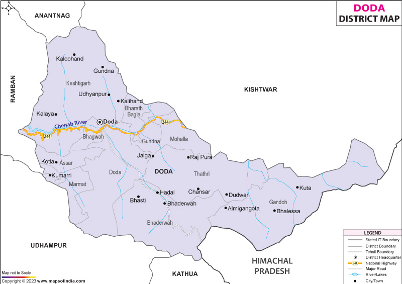
Rising sharply from the foothills, Doda district occupies a steep and varied stretch in the east of Jammu's territory. Though rarely mentioned on common maps, its terrain links gentle lower slopes with towering icy summits of Pir Panjal and Zanskar. To one side lies Kishtwar; across another edge sits Ramban. Southward stretches Udhampur and Kathua, while distant ridges touch both Chamba in Himachal and Anantnag beyond the valley. Because of such placement - neither fully lowland nor entirely alpine - it hosts shifting patterns of culture and landform alike. Where mountains meet here, so do ways of living shaped by altitude, climate, and quiet movement over centuries.
History & Culture
Doda's past unfolds through shifting power among mountain clans, fortified outposts, and waves of people moving across terrain. Small rulers called Ranas and Thakurs held sway here during earlier eras. Over time, authority shifted toward Kishtwar’s royal administration. For generations, the lush Bhaderwah basin - once named Bhadrakashi - thrived apart from larger states, linked culturally to Jammu in one direction, Chamba in another. By the 1800s, General Zorawar Singh, a Dogra military figure of note, brought these fragmented highland realms into a growing domain led by Maharaja Gulab Singh - the entity later known as Jammu and Kashmir. Doda city expanded steadily, shaped by an ancient mud fortress constructed by the Dogra rulers - a key storage site and defense point on highland trails. Though once within a vast border region, separation came later; 1948 marked its recognition as an independent administrative unit.
High up among steep peaks, Doda’s people carry traditions shaped by terrain. Connected to Jammu, Kashmir, and Himachal Pradesh, the region grows into a quiet meeting point - cultures meet without effort. Speech changes fast; one valley speaks Kashmiri, another near water uses Sirazi or Bhaderwahi. Cross a ridge, voices switch to Gojri or Dogri. Though Hindi and Urdu hold space in classrooms and government work, streets hum with shifting sounds. Each home may speak something unique, yet understanding still finds a way.
Music, dance, and festivity form the core of daily life here. Around bonfires, villagers join hands for the Kud dance, circling slowly to the heavy hum of large brass instruments paired with native drumbeats. Every year in Bhaderwah, Mela Patt unfolds - a tribute to a historic truce made long ago with Emperor Akbar - marked by grand parades and vibrant folk performances. Though rooted in past agreements, the spirit thrives now through shared moments across faiths. Celebrations such as Eid, Diwali, and Baisakhi belong not to one group but to all, carried forward quietly through common gestures and familiar routines.
Festivals in Doda pulse with energy, drawing entire valleys into one unfolding moment. While religious occasions such as Eid, Diwali, Shivratri, and Baisakhi pass through seasons, they leave behind a trace of common joy among varied groups. Deep beneath these practices lies an old devotion - to serpents, known locally as Naga beliefs - still alive near places like the Vasuki Nag Temple in Bhaderwah. As dusk settles on seasonal festivals, voices carry tales through darkness, rituals echo beyond memory, then wrestlers lock strength in open-air arenas called Dangal, revealing quiet pride and unmatched welcome woven into highland life.
Economy
What stands out about Doda is its varied economic structure, shaped by significant government services. High-elevation agriculture plays a key role here, adapted to tough mountain conditions. Power generation from renewable sources has grown across the region. Meanwhile, nature-focused travel draws increasing numbers each year.
Government Sector
Not far from the main roads, public jobs anchor household incomes throughout the area. Offices ranging from forest management to school oversight provide consistent work through every season. Thousands now find roles in branches of government, including legal services and administrative hubs. A medical college opened in Doda, followed by several undergraduate campuses spread across highland towns. These centers did more than create posts - they shaped skills, lifted learning access, and changed daily life.
Public Sector
High above sea level, government efforts shape large-scale construction and power systems vital for daily life in rugged terrain. With abundant rivers, this area uses flowing water to generate electricity - projects like Baglihar and Dul Hasti stand out, alongside minor plants feeding off streams of the Chenab River. These installations matter deeply within state-run energy networks. Maintaining road access falls under public responsibility; workers battle deep snow in cold months, then face heavy rains when seasons shift. Even remote settlements remain linked to economic centers because routes are kept open despite harsh conditions.
Services Sector
Nowhere has the economic shift been clearer than in the service industries, growing fast since the early 2000s, thanks to better roads, cross-border trade flows, and more visitors staying within local areas. Because banking reached further, even small towns now host branches that issue loans - supporting shop owners, drivers, alongside guesthouse founders building new ventures. What stands out most is movement: fleets of buses, pickups, heavy lorries pushing through steep, uneven paths each day, carrying food harvests, medicine, fuel toward urban hubs like Jammu and neighboring zones.
Farming stands out as a core strength in Doda, where natural conditions shape what grows. Thanks to distinct weather patterns, growers here raise vegetables outside typical seasons along with select high-value produce. Known far beyond local borders, Bhaderwah Rajmash from this region earns consistent praise - its naturally sweet flavor and fast-cooking texture set it apart within Indian kitchens.
Tourism
High up in the hills, the Doda district draws those who love wild landscapes and quiet trails. Rolling meadows stretch under open skies, fed by streams so clear you can see every stone below. Far from busy tourist routes, old shrines rest among rocky slopes and whispering pines. Solitude shapes the air here, thick with pine resin and morning frost. Few come, which keeps things unchanged, almost hidden.
Bhaderwah Valley
Bhaderwah earns the nickname "Mini Kashmir" because its scenery mirrors the rich terrain of the famous valley. Surrounded by towering pines and peaks draped in snow, it unfolds as a wide highland bowl. At almost 3,000 meters, Padri Pass spreads out - vast, grassy, inviting.
Jai Valley
Deep within the mountains, roughly 32 kilometers from Bhaderwah, lies Jai Valley - a long stretch of lush alpine grassland. Cutting across its center flows a bright, chattering stream fed by snowmelt. Towering deodar trees rise along each edge, enclosing the green space like silent sentinels. Because of its natural calm, visitors often wander here for quiet walks beneath open skies.
Chinta Valley
High above sea level lies Chinta Valley, draped in dense pine woods alongside stepped apple groves. Rising gently beyond tree lines are wide meadows, leading eyes toward the old Subar Nag Shrine perched along a sharp hilltop. From that height, everything spreads below - silent, vast. Hikers wander narrow footpaths between homes built close to the earth, watching how people tend crops just like generations before. Moments here slow down without notice. Mountain walls rise all around, catching light in ways few places manage. Peace does not announce itself - it simply stays.
Lal Draman
Lal Draman lies close to Doda city, a quiet meadow that few people know. Thick groves of fir and oak wrap around the open grassland, giving it a sense of calm apart from busy routes. Summer brings color through folk gatherings and village games held on the field, pulling in both locals and visitors without fanfare. Far from paved paths, it remains a rare patch of unspoiled landscape where hikers rest under stars and tents dot the green. Its value grows quietly - not loud, just real - through those who walk there seeking stillness among wild hills.
Demographics
Doda district holds a strong community shaped by tribes and highland life, marked by literacy and tight social bonds. Backed by 2011 government data, it counts 409,936 individuals calling the area home. Of these, men make up 213,641, whereas women number 196,295. For every thousand males, there are 919 females - a balance seen often in remote Himalayan regions. Most inhabitants stay rooted in countryside settings; about 88 percent live spread out across hillside farms and small clusters of homes. In contrast, just under one in eight now dwell within developing towns such as Doda city or Bhaderwah.
Though still below average, Doda district's literacy has climbed slowly over the years - now measured at 64.68%. Boys outpace girls in reading and writing skills; their rate rests high at 74.12%. In contrast, only about half of women across the region can read or write, marking female literacy at 54.26%. Progress appears uneven despite efforts made through government-led education drives since 2013. Schools built deep within mountain villages reflect one part of that push forward. Girls’ enrollment rose where incentives exist for families to send daughters to class instead of keeping them home. Behind these numbers lies persistent work - not sudden leaps - to balance learning chances between genders.
Administration
Deep inside the structure of regional administration, Doda functions as a key segment within Jammu's larger territorial framework. Civil oversight, management of land records, and delivery of social services rest under the authority of the Deputy Commissioner - also serving as District Magistrate - who guides these operations with consistent contact between departments. Running parallel, enforcement duties fall to the Superintendent of Police, whose role becomes especially vital along heavily traveled road corridors as well as isolated highland zones. Coordination between these two offices shapes much of how daily stability unfolds across varied terrain.
Spread out along the rugged valleys, Doda district splits into 17 administrative units known as tehsils. Each one operates under the supervision of a locally appointed Tehsildar. Efficiency in tax management and consistent access to services guide this structure. Instead of broad oversight, focused leadership helps meet community needs. Through these subdivisions, governance adapts to terrain challenges. Rather than centralizing control, authority disperses where it's needed most.
Bhaderwah Tehsil stands as a region rich in heritage, shaping cultural identity through time. Its landscape hosts key tourist areas alongside protected natural habitats. Governance here balances visitor access with environmental care. Tradition runs deep in community life across its villages. Ecological sensitivity guides land use decisions. Tourism thrives without overshadowing local customs. Settlement patterns reflect both mountain terrain and historical movement. Preservation efforts remain woven into daily practices.
Deep within the eastern mountains lies Gandoh (Balleesa) Tehsil, managing isolated settlements at great elevation. Its position shapes life in far-flung villages above the tree line. Rugged terrain defines daily existence here, where few roads reach. High-altitude living brings unique challenges throughout the year. Remote location limits access to services and supplies alike. Communities persist despite harsh weather and difficult travel. Life unfolds slowly, shaped by altitude and isolation together.
Scattered across the rugged terrain, Doda's countryside includes around 400 revenue villages grouped into multiple gram panchayats. Though small in size, each settlement functions through locally chosen councils operating under India’s Panchayati Raj framework. Leading such bodies, a Sarpanch - or sometimes called Pradhan - guides decision-making at the grassroots level.
| Facts of Doda District | |
|---|---|
| Official Name | Doda |
| Location | Jammu And Kashmir |
| Area (km2) | 2758.95 |
| Population | 409,936 |
| Language | Kashmiri, Urdu |
FAQs
Q1: How many villages are there in Doda district?
There are 400 villages in the district.
Q2: What is the population of the district?
The population of the district is 409936 according to the 2011 census.
Q3: What is the district famous for?
Besides rolling hills, Doda district holds fame through Bhaderwah Valley - nicknamed "Mini Kashmir" - where high-altitude fields such as Jai and Padri unfold in quiet beauty. Known across the country, its Rajmash beans stand out, not just rich in flavor but deeply tied to regional agriculture. Far from remote obscurity, this area sparked India’s so-called "Lavender Revolution," shifting traditional mountain cultivation into something entirely new. Growth here took root slowly, yet changed livelihoods in ways few expected.
Last Updated on : August 06, 2026
