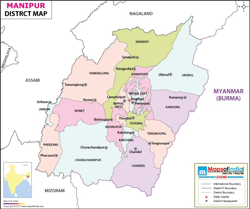
Districts and Administration of Manipur: Manipur has 16 districts. Each district is governed by a District Magistrate or a Deputy Commissioner, an officer belonging to the Indian Administrative Service. The District Magistrate or Deputy Commissioner is assisted by a number of officers from different wings of the state administrative service. A Superintendent of Police, an officer from the Indian Police Service is responsible for the law and order situation in the district.
Tourism in Manipur: Manipur is rich in culture and has a rich heritage in martial arts, classical dance, music, arts and sculpture. The state's moderate climate makes it a tourist delight. A few interesting tourist destinations in Manipur are, Shree Govindajee Temple, The Keibul Lamjao National Park (the only floating national park in the world), Loktak Lake, The War Cemetery, Manipur Zoological Garden and Manipur State Museum among others.
List of Districts in Manipur
| S No. | District | Headquarters | Population (Census 2011) | Sex Ratio (per 1000) | Average Literacy |
|---|---|---|---|---|---|
| 1 | Bishnupur | Bishnupur | 237,399 | 999 | 75.85% |
| 2 | Chandel | Chandel | 144,182 | 933 | 71.11% |
| 3 | Churachandpur | Churachandpur | 274,143 | 975 | 82.78% |
| 4 | Imphal East | Porompat | 456,113 | 1017 | 81.95% |
| 5 | Imphal West | Lamphelpat | 517,992 | 1031 | 86.08% |
| 6 | Senapati | Senapati | 193,744 | 959 | 74.13% |
| 7 | Tamenglong | Tamenglong | 140,651 | 943 | 70.05% |
| 8 | Thoubal | Thoubal | 422,168 | 1002 | 74.47% |
| 9 | Ukhrul | Ukhrul | 183,998 | 943 | 81.35% |
| 10 | Kangpokpi | - | - | - | - |
| 11 | Tengnoupal | - | - | - | - |
| 12 | Pherzawl | - | - | - | - |
| 13 | Noney | - | - | - | - |
| 14 | Kamjong | - | - | - | - |
| 15 | Jiribam | - | - | - | - |
| 16 | Kakching | - | - | - | - |
Last Updated on: June 24, 2026