|
||
 |
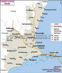
About Tamil Nadu
The state of Tamil Nadu is located on the southernmost region of the peninsular India. With its capital based in Chennai, which is the largest city of the state, it shares its geographical border with the other south Indian states of Andhra Pradesh, Karnataka and Kerala as well as Pondicherry that is one of the major Union Territories of the country.
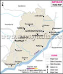
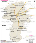
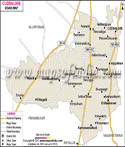
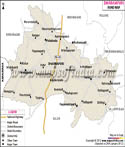
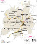
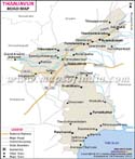
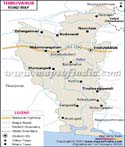
Road Map of Tamil Nadu
Being surrounded by so many important states of the Republic of India, the state has got a widespread network of roads. The entire road network of this state of south India accounts for about 1, 99, 040 km. of area on the earth's surface. Among this, the State Highways (S. H.) along with the National Highways (N. H.) cover approximately 14, 257 km. The Government of Tamil Nadu is considered unique for the creation of a separate department for the state's highways so as to improve and maintain the road transport system in Tamil Nadu. Known as the Highways Department or H. D., this department was formed in the month of April in 1946. The same was renamed on 30th October of the year 2008 as the Highways and Minor Ports Department or H. M. P. D. Apart from the highways that comes within the supervision of the Tamil Nadu Government, this department is even responsible for the maintenance of the National Highways as well as the main district roads, which pass through the state. Let us have a quick look at the highways passing through Tamil Nadu:
National Highways in Tamil Nadu
The state has got 25 National Highways that connects it to some of the major cities, capitals, ports, large industrial regions or popular tourist destinations of the nation. The following table provides a few of the basic information about those National Highways:
Sl. No. |
National Highways |
Names of States or Places, which the N. H. Pass Through |
1 |
N. H. - 4 |
Andhra Pradesh, Karnataka and Maharashtra |
2 |
N. H. - 5 |
Andhra Pradesh and Orissa |
3 |
N. H. - 7 |
Andhra Pradesh, Karnataka, Madhya Pradesh, Maharashtra and Uttar Pradesh |
4 |
N. H. - 7 A |
Tuticorin - Vagaikulam - Palayan Kottai |
5 |
N. H. - 45 |
Theni - Dindigul - Manapparai - Trichy - Ulundurpettai - Viluppuram - Tindivanam - Madurantakam - Chengalpattu - Tambaram - Chennai |
6 |
N. H. - 45 A |
Nagappattinam - Karaikal - Chidambaram - Cuddalore - Pondicherry - Villuppuram |
7 |
N. H. - 45 B |
Tuticorin - Ettaiyapuram - Pandalgudi - Aruppukottai - Madurai - Melur - Thuvarankurichchi - Viralimalai - Trichy |
8 |
N. H. - 45 C |
Vikravandi - Panruti - Neyveli Township - Vadalur - Sethiathope - Kumbakonam - Thanjavur |
9 |
N. H. - 46 |
Ranipet - Vellore - Vaniyambadi - Krishnagiri |
10 |
N. H. - 47 |
Kerala |
11 |
N. H. - 49 |
|
12 |
N. H. - 208 |
|
13 |
N. H. - 220 |
|
14 |
N. H. - 47 B |
Nagercoil - Aralvaymozhi - Kavalkinaru |
15 |
N. H. - 66 |
Karnataka and Pondicherry |
16 |
N. H. - 67 |
Karnataka |
17 |
N. H. - 207 |
|
18 |
N. H. - 209 |
|
19 |
N. H. - 68 |
Ulundurpettai - Kallakkurichchi - Chinnasalem - Attur - Valapadi - Salem |
20 |
N. H. - 210 |
Ramanathapuram - Devipattinam - Devakottai - Karaikkudi - Tirumayam - Pudukkottai - Trichy |
21 |
N. H. - 205 |
Andhra Pradesh |
22 |
N. H. - 219 |
|
23 |
N. H. - 234 |
|
24 |
N. H. - 226 |
Manamadurai - Sivaganga - Madagupatti - Tirupattur - Kilasevalpatti - Thirumayam - Pudukkottai - Gandharvakottai - Thanjavur |
25 |
N. H. - 227 |
Chidambaram - Kumaratchi - Lalpet - Kattumannarkoil - Gangaikondacholapuram - Jayamkondam - Udaiarpalayam - Kizhapalur - Kallakudi - Lalgudi - Trichy |
State Highways in Tamil Nadu
The network of the different State Highways in this state has got the following 7 circles:
- Chennai
- Coimbatore
- Madurai
- Salem
- Tamil Nadu
- Tirunelveli
- Trichy
Sl. No. |
Name of State Highway |
Number of State Highway |
1 |
Ennore - Chennai Road |
S. H. - 1 |
2 |
Jawaharlal Nehru Road or Chennai Inner Ring Road |
S. H. - 2 |
3 |
Renigunta - Tiruttani - Chennai Road (Upgraded to N. H. - 205) |
S. H. - 3 |
4 |
Villupuram - Gingee - Arni - Arcot Road |
S. H. - 4 |
5 |
Tindivanam - Vandavasi - Vandavasi - Arcot Road |
S. H. - 5 |
6 |
Tiruvannamalai - Kallakurichi Road |
S. H. - 6 |
7 |
Harur - Tiruvannamalai Road (Through Thanipadi) |
S. H. - 6 A |
8 |
Tirukkovilur - Mambalapattu - Villupuram Road |
S. H. - 7 |
9 |
Thanjavur - Kumbakonam - Neyveli Township - Panruti - Vikkiravandy Road (Converted to N. H. - 45 C) |
S. H. - 8 |
10 |
Chittoor - Katpadi - Vellore - Polur - Tiruvannamalai - Thirukovilur - Madapattu - Thiruvamur - Panruti - Nellikuppam - Cuddalore Road |
S. H. - 9 |
Other Roads in Tamil Nadu
Following are some of the special roads, which help the state connect to some of the important regions in the neighborhood:
- East Coast Road: Starting from Kudumiyandithoppu, this road runs till the suburbs of Pondicherry.
- Ennore - Manali Road: This road covers some of the other roads like Manali Oil Refinery Road, T. P. P. (Tiruvottiyur - Ponneri - Panchetti) Road, Ennore Expressway and Inner Ring Road's northern part.
- Maduravoyal - Chennai Port Expressway: Stretching from Maduravoyal to the Chennai Port, this is a 19 km long road.
- Outer Ring Road: This is a 6 lane road that runs from Minjur to Vandalur via Nemellichery.
- Rajiv Gandhi Salai or I. T. Expressway: This is a road stretching from Madhya Kailash to Mahabalipuram and connects to the East Coast Road.