Tiruvannamalai Tehsil Map


Tehsil Map of Tiruvannamalai

separator Click here for Customized Maps arrow custom map
Tehsil Map of Tiruvannamalai Kancheepuram Vellore Krishnagiri Dharmapuri Villupuram PUDUCHERRY ANDHRA PRADESH
Print Email Save Buy Now 
*Tiruvannamalai Tehsil Map highlights the name and location of all the mandals in Tiruvannamalai district, Tamil Nadu. Disclaimer


  Major Tehsils of Tamil Nadu  
Villupuram Tehsil Map Tirunelveli Tehsil Map Vellore Tehsil Map Coimbatore Tehsil Map
Villupuram Tehsil MapTirunelveli Tehsil MapVellore Tehsil MapCoimbatore Tehsil Map
    
Thanjavur Tehsil Map Madurai Tehsil Map Kancheepuram Tehsil Map Namakkal Tehsil Map
Thanjavur Tehsil MapMadurai Tehsil MapKancheepuram Tehsil MapNamakkal Tehsil Map
  other tehsils of Tamilnadu  >>

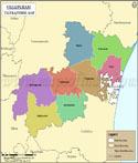
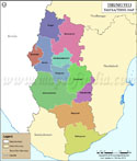
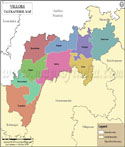
List of Taluks in Tiruvannamalai District

Taluk/Block NameTotal : Rural+Urban Population (2001) in NumberPin Code
Arani268,043632301
Chengam393,963606701
Cheyyar317,942604407
Polur398,647606803
ThandrampetN.AN.A
Tiruvannamalai490,971606601
Vandavasi316,559604408


Last Updated on : February 26, 2020