About Kanpur Metro
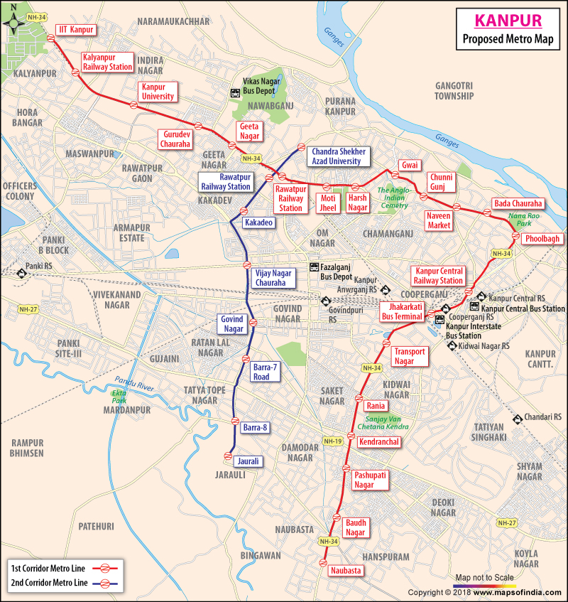
Kanpur is the largest district in the state of Uttar Pradesh in India. It is also the largest industrial town in the state. For the proper development, improvement and growth of the city, Metro will be introduced in Kanpur.
Two lines are proposed in the Metro map of Kanpur. The red line and blue line. The first line will be stretched from IIT Kanpur to Motijheel fall on Naubasta course. The second line will be stretched from Chandra Shekhar Azad University and Jarauli. The intermediate stations include Rawatpur, Bada Chauraha, Motimahal, Kanpur Central, ISBT Jhakarkatti and Naubasta. Rawatpur, Mall Road, Phoolbagh, Kanpur Central Station, and transport terminal of Jhakarkati-Kidwai Nagar. The estimated cost of Kanpur Metro Project is 350 crores. Japan International Cooperation Agency and European Investment Bank are going to provide loans for Kanpur Metro construction.
Last Updated on : November 13, 2025
- Aashiana
- Adarsh Nagar
- Ahmamau
- Aishbagh
- Alambagh
- Alamnagar
- Aliganj
- Amar Shaheed Path
- Amausi
- Amber Ganj
- Anand Nagar
- AP Sen Marg
- Arjunganj
- Arya Nagar
- Ashiyana Colony
- Ashok Marg
- Balaganj
- Banthra
- Barha
- Behta Saboli
- Bhadrukh
- Bharat Nagar
- Bijnaur
- Chand Ganj
- Charbagh
- Chaupatiyan
- Chinhat
- Civil Lines
- Dalibagh Colony
- Daliganj
- Darulshafa
- Deva Road
- Dilkusha Garden
- DLF Garden City
- Faizabad Road
- Ganesh Ganj
- Gari Chunauti
- Ghaila
- Ghazipur
- Goila
- Gokhale Marg
- Gomti Nagar
- Gudamba Thaana Road
- Guramba
- HAL
- Hazratganj
- Husainabad
- Hussainganj
- IIM Road
- Indira Nagar
- Jal Vayu Vihar
- Jankipuram
- Jopling Road
- Jugor
- Kalyanpur
- Kamalabad Barhauli
- Kanpur Road
- Kuroni
- Kursi Road
- Lalbagh
- Lucknow Cantonment
- Madion
- Mahanagar
- Mahipatmau
- Malesemau
- Manak Nagar
- Manas Nagar
- Maunda
- Miranpur Pinvat
- Mohan Meking Road
- Narayan Nagar
- Natkur
- Naubasta
- Naveen Galla Mandi
- Navi Kot Nandana
- New Ganeshganj
- New Hyderabad
- Nijampur Malhor
- Nilmatha
- Nirala Nagar
- Nirala Nagar
- Nishatganj
- Paikaramau
- Pan Dariba Marg
- Park Road
- Pawanpuri
- Piparsand
- Prag Narain Road
- Rae Bareli Road
- Rahim Nagar
- Rajajipuram
- Rajendra Nagar
- Ram Mohan Rai Marg
- Rasoolpur Sadat
- Ruchi Khand-II
- Saadatganj
- Sadrauna
- Sapru Marg
- Sarai Mali Khan
- Sarojini Nagar
- Sarosa Bharosa
- Sarvodaya Nagar
- Sector-14
- Sector-18
- Sector-B
- Sector-D
- Shahnajaf Road
- Sharda Nagar
- Shyam Vihar Colony
- Sikrauri
- Singar Nagar
- Subhash Marg
- Sujanpura
- Sunder Bagh
- Sushant Golf City
- Telibagh
- Thakurganj
- The Mall Avenue
- Tilak Marg
- Triveni Nagar
- Uattardhona
- Utrathia
- Vasant Kunj
- Vibhuti Khand
- Vikas Nagar
- Vineet Khand
- VIP Road
- Vishesh Khand
- Vivekanandpuri
- Vrindavan Yojana
