| |
Major Cities of West Bengal |
|
 |
 |
 |
 |
| Barrackpore City Map | Bankura City Map | Kalimpong City Map | Salt Lake City Map |
| | | | |
 |
 |
 |
 |
| Asansol City Map | Durgapur City Map | Darjeeling City Map | Kolkata City Map |
| | | other cities of West Bengal >> |
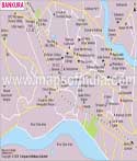
A city and municipality in the district with the same name, Bankura is located in West Bengal. It is also the headquarters of Bankura district. The district has been a centre of western Bengal's Malla kingdom and its nearby areas have immense cultural and historical significance. There are difference in opinions and beliefs about the history of the word 'Bankura' According to some scholars, it is named after an influential God known as Bankura Roy; while as per some other beliefs it came from the word 'Banka' which means zig-zag. The geographical location of Bankura district is 23° 14' N 87° 07' E and it has an average elevation of 78 metres. As per census 2011, the population of the city is 1,38,036.
Bankura is predominantly an agrarian society with majority of the population being involved in agricultural and irrigation activities. Although being a draught prone region of West Bengal, it still manages to support the state's population. Due to the emergence of the land reforms and irrigation systems, agriculture has improved in the city with the production of hybrid and high fertile crops. There are also many cottage and small scale industries like weaving, handicrafts and oilseed-crushing which contribute to the economy of the city. Mines and minerals in the Bankura district play an important role in its economy. Chhatna, Ranibundh and Saltora Khatra are some of the regions in the district with minerals and mines resources. The medicinal flora and fauna available in the forest of the district also support the economy of the region. There are many well-known places in Bankura which bring tourists to the city. Hence, a portion of income of the city is also dependant on the tourism industry.
The rich traditional and the cultural heritage of the city attract many tourists from several places of the country. The historical destinations and the beautiful locations bring the tourist to this place. Painting, music, art and architecture and some other art forms make Bankura a favourite tourist spot. Bishnupur, the most famous tourist spot near Bankura is known for baluchari sarees and terracotta temples. Susunia Hill and Biharinath Hill are popular for their green unpolluted environment, water bodies, dense forests and healthy atmosphere. A holy place, Joyrambati is the birthplace of Sree Sree Maa Sarada Devi and has places like Mayerepukur and the temple of the Singha Bahini Devi visited by many people. The second biggest earthen dam in India, Mukutmanipur is also located near Bankura. Gandoa Dam, Koro Pahar and Durgapur barrage are some of the other places of interest in the city.
The Bankura Railway Junction, which is managed by the South Eastern Railways, connects it to many major cities. Midnapore Railway Station is another main station near Bankura. NH-34 connects it to other places, but Bankura does not have any bus stop of its own. Durgapur is the nearest bus stop to Bankura from where one can take other public/private transport. The nearest airport to Bankura is the Netaji Subhash Chandra Bose International Airport, Kolkata.
WBST200415
Last Updated on : June 24, 2026
