|
|||||
 | |||||
|
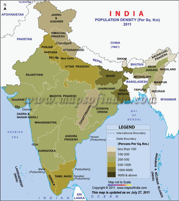
*The Map showing Population Density of India in Census 2011.
Disclaimer: All efforts have been made to make this image accurate. However Mapping Digiworld Pvt Ltd and its directors do not own any responsibility for the correctness or authencity of the same.
Disclaimer: All efforts have been made to make this image accurate. However Mapping Digiworld Pvt Ltd and its directors do not own any responsibility for the correctness or authencity of the same.
Different types of methods to measure population density
Given below are the different methods of calculating population density:
- Arithmetic density: The overall number of inhabitants/ land area (calculated in sq miles or km2).
- Agricultural density: The overall agrarian population/area of productive farming land.
- Physiological density: The overall population/area of productive farming land.
- Urban density: Population peopling a metropolitan region/overall area of metropolitan region.
- Residential density: Population inhabiting a metropolitan region/area of housing space.
- Ecological optimum: Population density which is backed by the natural reserves.
Density of Population of India
The population density of India is 364.9/km2 and India ranks as the 31st most densely populated country in the world.
Table describing the population density of India
The table given below will provide a clear idea about the population density of India, its different states, and union territories:
| Population Density of India |
| Serial No. | India/ States/UT | 2001 | 2011 |
| - | INDIA | 324 | 382 |
| 1 | Jammu and Kashmir | 99 | 56 |
| 2 | Himachal Pradesh | 109 | 123 |
| 3 | Punjab | 482 | 550 |
| 4 | Chandigarh (UT) | 7903 | 9252 |
| 5 | Uttaranchal | 159 | 189 |
| 6 | Haryana | 477 | 573 |
| 7 | Delhi (UT) | 9294 | 9340 |
| 8 | Rajasthan | 165 | 201 |
| 9 | Uttar Pradesh | 689 | 828 |
| 10 | Bihar | 880 | 1102 |
| 11 | Sikkim | 76 | 86 |
| 12 | Arunachal Pradesh | 13 | 17 |
| 13 | Nagaland | 120 | 119 |
| 14 | Manipur | 107 | 122 |
| 15 | Mizoram | 42 | 52 |
| 16 | Tripura | 304 | 350 |
| 17 | Meghalaya | 103 | 132 |
| 18 | Assam | 340 | 397 |
| 19 | West Bengal | 904 | 1030 |
| 20 | Jharkhand | 338 | 414 |
| 21 | Orissa | 236 | 269 |
| 22 | Chhatisgarh | 154 | 189 |
| 23 | Madhya Pradesh | 196 | 236 |
| 24 | Gujarat | 258 | 308 |
| 25 | Daman & Diu (UT) | 1411 | 112 |
| 26 | Dadra & Nagar Haveli (UT) | 449 | 491 |
| 27 | Maharashtra | 314 | 365 |
| 28 | Andhra Pradesh | 275 | 308 |
| 29 | Karnataka | 275 | 319 |
| 30 | Goa | 363 | 394 |
| 31 | Lakshadweep(UT) | 1894 | 2013 |
| 32 | Kerala | 819 | 859 |
| 33 | Tamil Nadu | 478 | 555 |
| 34 | Pondicherry (UT) | 2029 | 2598 |
| 35 | Andaman and Nicobar Islands(UT) | 43 | 46 |
West Bengal ranks as the state with the maximum density of population in India and its area is 88,752 sq km. As stated by the census conducted in 2001, the population density of West Bengal was 904. In 1991, West Bengal had a population of 68,077,965 and its density of population was 767. According to the census of 2001, the total population of West Bengal was 8,01,76,197. The state with the lowest population density is Arunachal Pradesh and the Union Territory with the lowest density of population is Andaman & Nicobar Islands. The Union Territory with the highest population density is Delhi.
Density of population of India in a chronological order
| Density of population of India in a chronological order |
| Year | Density of population per sq km |
| 1901 | 77 |
| 1911 | 82 |
| 1921 | 81 |
| 1931 | 90 |
| 1941 | 103 |
| 1951 | 117 |
| 1961 | 142 |
| 1971 | 177 |
| 1981 | 216 |
| 1991 | 274 |
| 2001 | 324 |
Last Updated on :February 13, 2019
