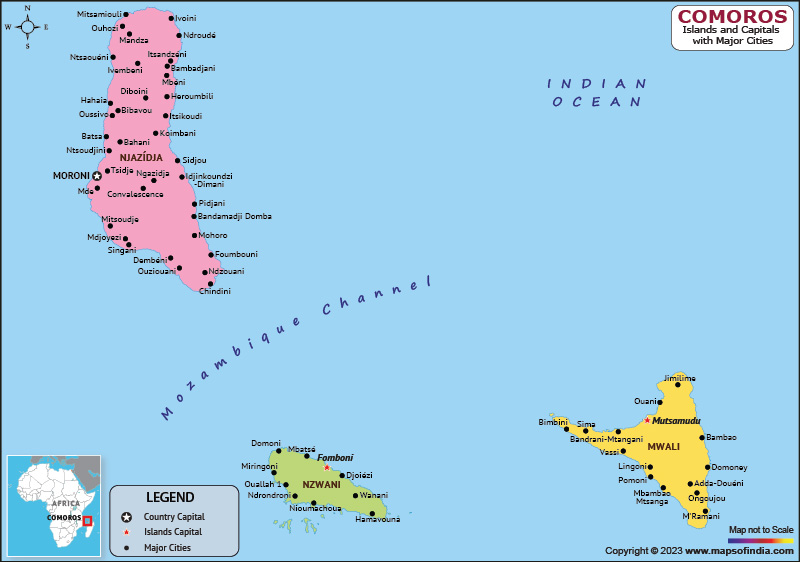
Comoros is an independent country in southeastern Africa. Moroni is the capital and largest city of Comoros. As a member of the Arab League, it is the only country in the Arab world located throughout the southern hemisphere. It is a member of the African Union, Francophone International Organization, Organization of Islamic Cooperation, and Indian Ocean Commission.
History:
This sovereign nation consists of three large islands and many smaller ones, all of which, except for Mayotte, is located in the volcanic Comoros archipelago. Mayotte, which voted against independence from France in a 1974 referendum, has never been administered by an independent Comorian government since and is still administered by France as an overseas department.
France vetoed a UN Security Council resolution affirming Comoro’s sovereignty over the island. In 2011, following an overwhelming referendum, Mayotte became an overseas department and region of France.
Culture:
Women in Ndzwani traditionally wear red and white patterned clothes called shiromani, while in Ngazidja and Mwali they wear colorful shawls called leso. Women in Comoros apply a paste of ground sandalwood and coral called msinzano to their faces. Traditional men's clothing is a long white shirt called nkandu and a floppy hat called kofia.
Imported from Zanzibar in the early 20th century, Twarab music remains the island's most influential genre and is popular at ada weddings.
Language:
The most widely spoken language in Comoros is the Comorian language collectively known as Shikomori. It is related to Swahili, with four variants spoken on each of the four islands. French and Arabic are also the official languages of the country. Arabic is widely known as a second language and is an instructional language for the Quranic. French is the language of administration and the language of most non-Quranic official teaching.
Geography:
The country has three large and many smaller islands in the Comoros archipelago. The island is officially known by its Comorian name, but international sources still use its French name. The archipelago is located between the Indian Ocean, the Mozambique Strait, the coast of Africa, and Madagascar and has no borders. The country has two volcanos La Grille and Karthala, and even the country was formed by volcanic activities.
| Official name | Union of Comoros |
| Capita | Moroni |
| Population | 8.22 lakhs (2021) |
| Area | 2,235 sq km |
| Currency | Comorian Franc |
| Religion | Sunni Muslim |
| Language | Comorian, French, Arabic |
| Major cities | Moroni, Fomboni, Demoney |
FAQs
Q.1. What is the climatic condition of Comoros?
Ans. The climate in Comoros generally stays mild and tropical.
Q.2. What is the government system in Comoros?
Ans. The country has a federal presidential republic, where the President stands as both head of state and head of government.
Q.3. What is the capital of Comoros?
Ans. Moroni is the capital of Comoros.
Last Updated on: April 17, 2023
