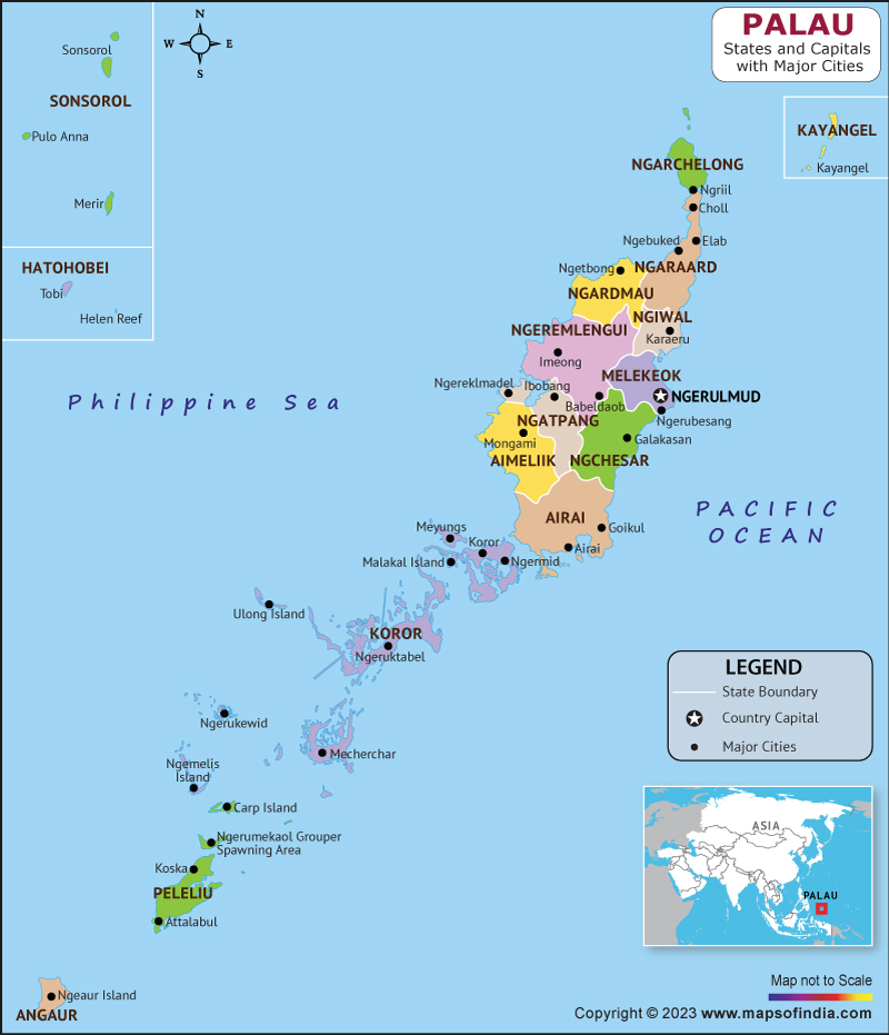
Palau, officially known as the Republic of Palau, is a tiny island state situated in the western portion of the Pacific Ocean. The country is made up of over 500 islands and islets, which are spread out over an area of about 458 square kilometers. Palau is known for its beautiful natural scenery, including coral reefs, pristine beaches, and lush forests.
History:
Palau has a long and complex history that dates back thousands of years. The islands were first settled by Austronesian-speaking people who migrated from Asia. Over the centuries, Palau was ruled by various empires and kingdoms, including Spain and Germany. During World War II, Palau was occupied by Japan and was the site of a major battle between Japanese and American forces. Palau attained independence from the United States of America in the year 1994.
Culture:
Palauan culture is rich and diverse, with influences from Micronesian, Melanesian, and Polynesian traditions. One of the most important cultural practices in Palau is the traditional system of chieftainship, which is still recognized and respected today. Music and dance are also an important part of Palauan culture, with traditional instruments such as the kere (a type of wooden drum) and the chub (a bamboo flute) still used in performances. Palauan cuisine is known for its use of fresh seafood, tropical fruits, and vegetables.
Language:
The majority languages of Palau are Palauan and English. Palauan is a member of the Austronesian language family and is spoken by the majority of the population. English is widely used in schools, government, and business settings.
Geography:
Palau is located in the western portion of the Pacific Ocean, the eastern front of the Philippines, and the northern front of Indonesia. The country is made up of over 500 islands and islets, which are divided into 16 states. The largest island is Babeldaob, which is also the location of the capital city of Ngerulmud. Palau is known for its diverse marine life, including over 1,400 species of fish and 700 species of coral. The Rock Islands, a group of limestone islands and islets, are a UNESCO World Heritage Site and a popular tourist destination.
| Official Name | Republic of Palau |
| Capital | Ngerulmud |
| Population | 18024 |
| Area | 459 km2 |
| Currency | Dollar |
| Religion | Christianity |
| Language | Palauan, English |
| Major Cities | Airai, Meyuns, Ollei |
FAQs
Q1: Is Palau prone to Typhoons?
Palau is prone to typhoons and tropical storms, especially during the wet season.
Q2: What is the economy of Palau based on?
The economy of Palau is heavily dependent on tourism, which accounts for a significant portion of the country's GDP. Other important industries include fishing and agriculture, particularly the production of copra (dried coconut meat) and taro. Palau also receives financial aid from the United States, which is an important source of government revenue.
Q3: What is the population of Palau?
As of 2021, the population of Palau is estimated to be around 21,000 people. The majority of the population lives on the main island of Babeldaob, which is home to the capital city of Ngerulmud.
Q4: What are some popular tourist attractions in Palau?
Palau is known for its natural beauty, and many tourists come to explore the country's coral reefs, beaches, and forests. Some popular attractions include the Rock Islands, Jellyfish Lake (where tourists can swim with stingless jellyfish), and the Palau International Coral Reef Center. Scuba diving and snorkeling are also popular activities due to Palau's diverse marine life.
Last Updated on: April 11, 2023
