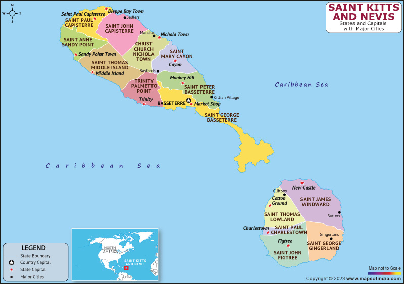
Officially, Saint Kitts and Nevis is known as the Federation of Saint Christopher and Nevis. It is an island nation with two islands in the West Indies that are a part of the Lesser Antilles' Leeward Islands chain. It is the tiniest sovereign federation in the world covering 261 square kilometers. Charles III serves as the nation's monarch and head of state. It is the only country that has sovereign federation in the Caribbean.
Basseterre, the capital city, is situated on Saint Kitts' island. Additionally, the primary port for cargo and passenger entry is Basseterre. Across a narrow channel known as The Narrows, Nevis, a smaller island, is located about 3 kilometers (2 miles) southeast of Saint Kitts. The volcanic islands of St. Kitts and Nevis. As a result, they have a rather unpredictable geologic history and lush tropical vegetation, and central mountains.
History:
The first British colony in the Caribbean was established in 1623 on what is now Saint Kitts and Nevis. Saint Kitts and Nevis, along with Anguilla, became a self-governing state in association with Great Britain in 1967, ending centuries of British and French colonial rule. The two-island federation and the United States have had cordial diplomatic ties ever since Saint Kitts and Nevis gained independence in 1983.
Culture:
The West African traditions of the slave population imported during the colonial era are responsible for the culture of St. Kitts and Nevis, two small Caribbean islands. The seasoned warriors of the native Caribs protected their homeland by attacking the colonies. However, the British had taken over St. Kitts and Nevis by 1782, and they remained in charge of the islands until independence in 1983. On St. Kitts, Carnival is in full swing during the holiday season. Mid-December sees the opening gala, and festivities continue until New Year.
Language:
Only English is used in official documents. Around 40,000 people in Saint Kitts and Nevis speak a variant of Creole English known as Saint Kitts Creole. The accent used in the islands has a West Indian inflection. The majority of the population on the islands can communicate in the language.
Geography:
Only 270 square kilometers make up the entire landmass of Saint Kitts and Nevis. The larger of the two islands, St. Kitts, measures 180 square kilometers and is situated at latitude 17.30 N and longitude 62.80 W. Nevis is 93 square kilometers in size and is situated 3 kilometers south-east of St. Kitts at latitude 17.10 North and longitude 62.35 West.
| Official Name | Federation of Saint Christopher and Nevis |
| Capital | Basseterre |
| Population | 48300 |
| Area | 261 km² |
| Currency | East Caribbean Dollar |
| Religion | Protestant |
| Language | English |
| Major Cities | Basseterre, Cayon,Charlestown |
FAQs
Q1: What is the official language of Saint Kitts and Nevis?
English is the official language of Saint Kitts and Nevis.
Q2: What is the capital of Saint Kitts and Nevis?
Basseterre is the capital of Saint Kitts and Nevis.
Q3: What is the currency of Saint Kitts and Nevis?
East Caribbean Dollar is the currency of Saint Kitts and Nevis.
Q4: What is the climate in Saint Kitts and Nevis?
Along with warm and humid conditions and as with most Caribbean islands, the climate of St. Kitts and Nevis is heavily influenced by the marine environment.
Last Updated on: May 19, 2023
