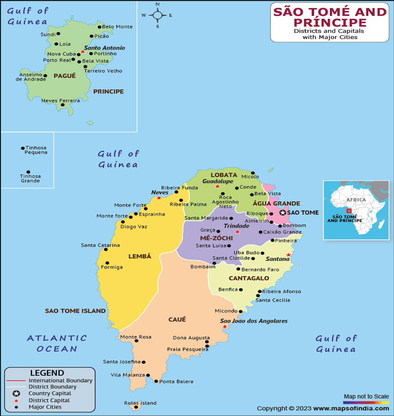
Sao Tome and Principe is a tiny island nation situated off the western coast of the African continent. Sao Tome and Principe, and several other islands smaller are present in the nation. The country's capital and largest city is Sao Tome.
History:
When Portuguese sailors first landed in the late 15th century, the islands were uninhabited. The islands were seized by the Portuguese, who began utilising them as a stopover for ships sailing to and from their African possessions. They imported sugar cane farming and slaves from the African continent to operate the plantations.
In the late 19th century, Sao Tome and Principe became major exporters of cocoa, and the islands' economy was heavily dependent on this crop until the mid-20th century. The country gained independence from Portugal in 1975 and became a democratic republic.
Culture:
Sao Tome and Principe has a diverse culture that reflects its African and Portuguese heritage. The islands are known for their lively music, dance, and festivals. One of the most popular styles of music is called "soca," which combines African rhythms with Portuguese melodies.
Language:
The official language of the nation is Portuguese, which is spoken by the majority of the population. However, many people also speak Creole, a Portuguese-based creole language that has evolved over centuries of contact between Portuguese colonizers and African slaves. Creole is used in informal settings and is a symbol of national identity.
Geography:
Sao Tome and Principe is a volcanic archipelago located in the Gulf of Guinea, approximately 300 kilometers off the coast of Gabon. The islands are of volcanic origin and have rugged terrain, with steep hills and deep valleys. The highest point is Pico de Sao Tome, which rises to an elevation of 2,024 meters. The islands have a tropical climate, with high humidity and temperatures ranging from 22°C to 30°C.
| Official Name | Democratic Republic of Sao Tome and Principe |
| Capital | Sao Tome |
| Population | 223107 |
| Area | 964 km2 |
| Currency | Dobra |
| Religion | Christianity |
| Language | Portuguese |
| Major Cities | Santo Antonio, Santana, Guadalupe |
FAQs
Q1: What is Sao Tome and Principe?
Sao Tome and Principe is a tiny island nation situated off the western coast of the African continent in the Gulf of Guinea.
Q2: What is the population of Sao Tome and Principe?
As of 2021, the population of Sao Tome and Principe is estimated to be around 219,159 people. The majority of the population is of African descent, with Portuguese and other European influences.
Q3: What is the economy like in Sao Tome and Principe?
The economy of Sao Tome and Principe is largely dependent on agriculture, with cocoa being the primary export. The country has also recently begun to develop its tourism industry, which has the potential to bring in additional revenue.
Q4: What are some popular tourist attractions in Sao Tome and Principe?
Some popular tourist attractions in Sao Tome and Principe include its beautiful beaches, lush forests, and diverse wildlife. The Pico Cão Grande, a volcanic spire rising out of the jungle, is also a popular attraction for hikers and climbers.
Last Updated on: April 18, 2023
