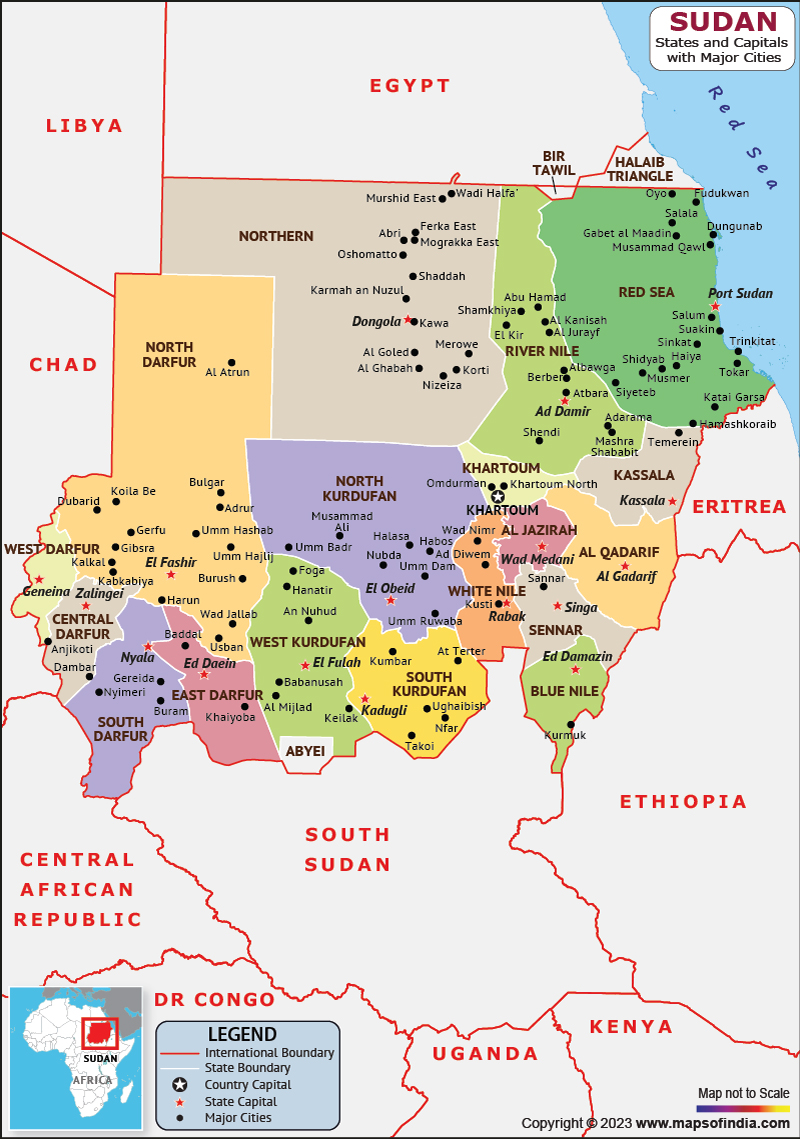
Sudan is a country in Northeast Africa. It shares its borders with Egypt to the north, the Central African Republic to the southwest, Eritrea to the northwest, Chad to the west, Libya to the northwest, Ethiopia to the southeast, the red sea, and South Sudan to the south. Khartoum is the most populous city and capital of Sudan.
History:
The Sultan's history dates back to the pharaohs and saw the rise of the Kingdom of Korma, followed by the rule of the New Kingdom of Egypt and the Kingdom of Kush, which ruled Egypt for nearly a century.
From the 14th to the 15th century, most of Sudan was gradually colonized by Arab nomads. From the 16th to the 19th century, the central and eastern part of Sudan was ruled by the Sultanate of Funj, Darfur ruled the west, and the Ottoman Empire ruled the east.
From the beginning of the 19th century, the Egyptians under the dynasty of Muhammad Ali conquered all of Sudan. It was under Egyptian rule that Sudan began the process of agricultural, political and economic development, and also acquired its modern borders. Sudan declared its independence on January 1, 1956.
Culture:
Sudanese culture is an amalgamation of the behaviours, customs and beliefs of approximately 578 peoples who communicate in many different dialects and languages, in a microscopic region of Africa with extreme geography ranging from deserts to rainforests.
Sudan has a rich and unique musical culture that has seen long periods of turmoil and repression throughout Sudan's modern history. Most Sudanese wear traditional or Western clothing. The traditional garment widely worn by Sudanese men is the galabiya, a loose-fitting, long-sleeved, collarless, ankle-length garment that is also common in Egypt.
Language:
There are 70 native languages of Sudan. It has multiple regional sign languages. Arabic was the sole official language of Sudan, before 2005. But after that English and Arabic, both became the National languages.
Geography:
Sudan lies between latitudes 8 degrees and 23 degrees North. The terrain is generally flat plains separated by several mountain ranges. To the west, the Deriba Crater in the Mara Mountains is the highest point in Sudan. To the east is the Red Sea Mountain.
The Blue Nile and White Nile rivers form the Nile flowing through the Mediterranean Sea. There are several dams on the White and Blue Niles. Among them are the Roseires and Sennar Dams on the Blue Nile and the Jebel Aulia Dam on the White Nile.
| Official name | Republic of Sudan |
| Capital | Khartoum |
| Population | 4.57 crores (2021) |
| Area | 1.886 million sq km |
| Currency | Sudanese pound |
| Religion | Muslim |
| Language | Arabic and English |
| Major cities | Khartoum, Omdurman, Nyala |
FAQs
Q.1. What is the climatic condition of Sudan?
Ans. The northern and central parts have extremely dry and desert areas, and the rainfall increases towards the south. There are grasslands and tropical savanna in the south.
Q.2. What is the capital of Sudan?
Ans. Khartoum is the most populous city and capital of Sudan.
Last Updated on: May 19, 2023
