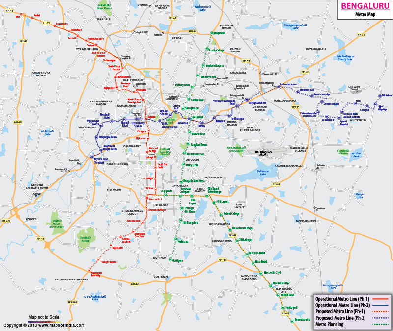
Bangalore (officially called Bengaluru) is known as the IT capital of India. With the growth of IT-related businesses in the city, the need for infrastructure development also picked the pace. Hence, the construction of metro system in the city was proposed and subsequently, its implementation process took off.
To learn about the route, passengers can browse through the map of Bangalore metro rail. The map is quite detailed and shows the routes in a lucid manner.
Need for Metro in Bangalore
Main objective behind introduction of metro rail in Bangalore was to ease the traffic pressure off the roads. The making of metro line was also encouraged, so that travellers start using public transport more and more, instead of using private vehicles. Metro system in the city is considered to be a complementary transit mode rather than a competitive one.
In addition to that, metro system in Bangalore was also needed for following reasons:
-
To reduce consumption of fuel
To check pollution
To bring down accident rates
To help travellers save their time
Bangalore, the IT hub of India, finally got its own metro rail. Former Urban Development Minister Kamal Nath inaugurated the service for Reach-1(MG Road to Baiyappanahalli Station) on 20 October 2011. Pace had picked up for completion of Mysore Road to Kengeri (Reach 2) and (Reach 4) Yelachenahalli to Anjanapura Township.The operations for Reach-3, 3A (Penny Industry to Mantri Square Sampige Road Station) began on 1 March 2014. After the completion of the entire project, the Bangalore Metro, also named 'Namma Metro' (Our Metro), is expected to reduce the traffic volumes in congested parts of the city, like Kempegowda Bus Stand, Bangalore Bus Stand, Hudson Circle and M.G Road.
Schedule and Frequency of Bangalore Metro
Construction work on the corridor from Baiyappanahalli to M G Road started in December 2006. The network link under Phase I was expected to be fully operational by December 2011; however, its operations began from 20 October 2011.
The metro service runs between 6 a.m. to 10 p.m. daily. The frequency of the metro rails is 15 minutes from 6 a.m. to 8 a.m. and from 8 p.m. to 10 pm. However, during the peak hours from 8 a.m. to 8 p.m. the trains run at a frequency of 10 minutes. Passengers travelling on East-West corridor will have to spend 33 minutes, while it is 28-minute wait time on North-South corridor. The maximum train speed is 80 kmph.
To know about routes, you can follow the Bangalore metro map.
Routes shown on Bangalore Metro Map
Metro trains in Bangalore pass through various residential and commercial areas to help passengers reach their desired location. Well integrated with other modes of public and private transport, the metro on its East-West corridor links Baiyappanahalli with Mysore Road and on North-South corridor connects Nagasandra to Puttenahalli.
Current Routes
The metro train routes of East-West corridor and North-South corridor are given below:
1. East-West corridor
Baiyappanahalli - Swami Vivekananda Road - Indiranagar - Halasuru - Trinity - Mahatma Gandhi Road - Cubbon Park - Vidhana Soudha - Sir M. Visveshwaraya -Kempegowda - City Railway Station - Magadi Road - Hosahalli - Vijayanagar - Attiguppe - Deepanjali Nagar - Mysore Road
2. North-South corridor
Nagasandra - Dasarahalli - Jalahalli - Peenya Industry - Peenya - Yeshwanthpur Industry - Yeshwanthapur - Sandal Soap Factory - Mahalakshmi - Rajajinagar - Kuvempu Road - Srirampura - Mantri Square Sampige Road - Kempegowda - Chickpete - Krishna Rajendra Market - National College - Lalbagh - South End Circle - Jayanagar - Rashtreeya Vidyalaya Road - Banashankari - Jaya Prakash Nagar - Puttenahalli
For better understanding, you are recommended to go through the Bangalore metro map, which is both clear and comprehensive.
Metro Fares
Metro fares for the current running metro trains are minimum Rs. 10 and maximum Rs. 60. BMRC also offers the facility of the smart cards to the commuters. The travellers can avail discounts on the ticket prices by using their smart cards.
Namma Metro Smart Card
Namma Metro Smart Card, also known as ICICI Bank Unifare Bangalore Metro Card, was launched by the Bangalore Metro Rail Corporation Limited (BMRCL) along with ICICI Bank, which is one of India's largest private-sector banks. The smart card has an exclusive feature that provides the commuters with both credit as well as debit privileges. It uses the Near Field Communication (NFC) technology and offers duple benefits to the commuters. The card provides a unique auto-recharge facility, which means that when the balance in your card goes below Rs. 100, then automaticallyRs. 200 will be credited into your card. By using this facility, the commuters need not have to wait in queues at the vending machines or the ticket counters to get their cards recharged.
Bangalore Metro Phase I Deadline extended till March 2016
Karnataka Chief Minister Siddaramaiah signalled that the deadline for the first phase of Bangalore Metro be pushed to March 2016 instead of the projected deadline of December 2015. The CM said that technical difficulties in the underground sections had delayed the work, which might impact the deadline of completing the 42.3 km stretch. The CM gave this indication during the inauguration of the Reach 3B extension of Phase I. The new extension has been done covering a stretch of 3.4 km between Nagasandra and the Peenya industrial area. From now on, a stretch of 10.5 km from Mantri Mall to Nagasandra will be covered by the metro in just 25 minutes.
WBST210515
WBVDA
Last Updated on : November 13, 2025

