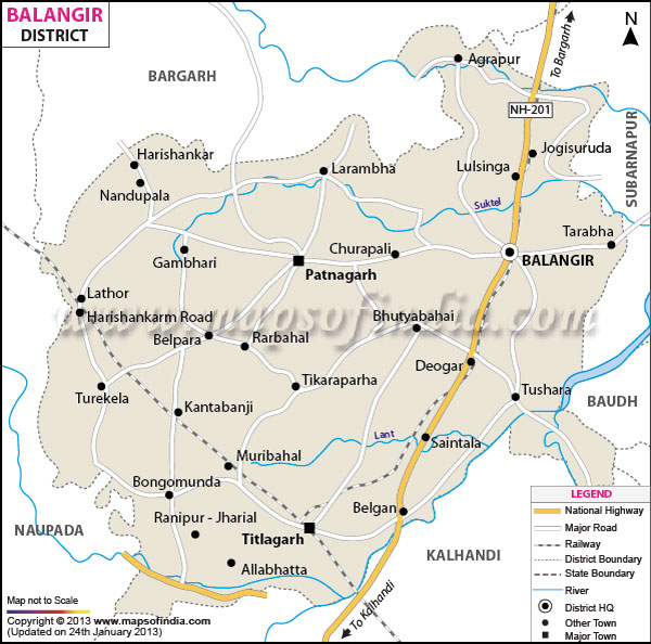
The district has a population of 13, 36,000 according to 2001 census. While the literacy rate of the district is 54.91%, the population density is 203 per person per sq km (census 1991).
With a total cultivable land of 3, 45, 650 Balangir earns revenue through its mining, small scale, handicrafts and cottage industries.
Blessed with a huge reserve natural beauty, Balangir boasts of some exquisite places of interest. These include Samaleswari, Ram and Patmeswari Temples, Patnagadh, Ranipur - Jharial, among others. Balangir district is further sub divided into three distinct regions for administrative convenience. Balangir district comprises of 6 tehsils, 14 blocks and 1792 villages. Balangir bears relics to the rich historical and cultural civilization of the ancient times. During the 1880's, Balangir played an important role in the social, economic and political development of the state of Patna.
Representing the religious fervor of the local indigenous inhabitants of the district, Balangir has several places of religious importance that draws numerous devotees from far and wide. Some of the important religious shrines of Balangir district are:
- Sri Rama Temple
- Samaleshwari Temple
- Patmeswari Temple
Balangir district of Orissa is spread over a total geographical area of 6569 sq. km. Comprising mostly of tribal inhabitants, Balangir district encompasses a population of 13, 35,760 as per the census data of 2001. Located in the western region of Orissa, the district of Balangir shares its northern border with Bargah, southern border with Kalahandi, eastern side with Sonepur and western side with Nuapara.
Balangir district is further sub divided into three distinct regions for administrative convenience. Balangir district comprises of 6 tehsils, 14 blocks and 1792 villages. Balangir bears relics to the rich historical and cultural civilization of the ancient times. During the 1880's, Balangir played an important role in the social, economic and political development of the state of Patna.
Representing the religious fervor of the local indigenous inhabitants of the district, Balangir has several places of religious importance that draws numerous devotees from far and wide. Some of the important religious shrines of Balangir district are:
- Sri Rama Temple
- Samaleshwari Temple
- Patmeswari Temple
Blessed with natural scenic beauty, Balangir district is an ideal destination for tourists. Some of the notable places of tourist interests of the district of Balangir are:
- Mursing
- Saintala
- Patnagarh
- Jal Mahadev
- Jogisarda
- Harishankar
- Ranipur- Jharial
- Gaikhai M.I.P
- Tenttulikhunti
Last Updated on : February 19, 2026
