







About
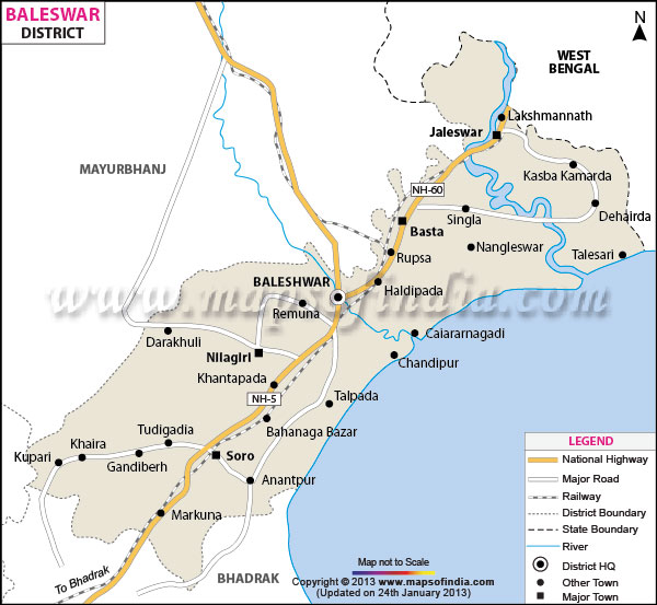
Venturing into those shades of swaying waves and golden horizon that dappled in emerald paddies of the restless Bay of Bengal, lies a field of transcendent beauty and strategic power. This is Baleshwar—a land which touches the imagination immediately. A look at a Baleshwar district map, however, and one will realise how significant Baleshwar is as a gateway to the coast, securely knotted within the northeastern corner of Odisha. The very name has a deep and holy connotation. Its name is derived from the Sanskrit terms "Baneshwar" or "Baleshwar," which are associated with Lord Shiva/Baleshwar, respectively, thus honouring the divine protector of such an ancient sea area.
Surrounded by the majestic, blue, curvaceous Nilagiri Hill range on its west and the sparkling, stormy sea on its eastern side, the region lies in the holiest territory of the globe. With this knowledge and exploring a Baleshwar district map, the circle is bounded by West Bengal to the north, Mayurbhanj to the west, Bhadrak to the south and the vast ocean in the east. Around this rich, coastal plain, energy abounds and life is literally on the move.
History & Culture
The land of Baleshwar is rich with ancient history, having witnessed the rise and fall of great empires, sea stories and revolution. Once, centuries ago, merchants sailed from these shores to distant kingdom after kingdom in Southeast Asia in search of exotic spices, silks and crafts—these were called Sadhabas. The glory of the sea is vividly recalled when tracing back the Baleshwar district map from any historical period. The area has seen great art and architectural development in medieval times, when it was nurtured by the patronage of the Ganga and the Gajapati reigns.
In the times of European supremacy in the sub-continent, Baleshwar became an important centre of European trade, with several European powers establishing trading interests in the region. Bloodshed, treaties were signed and the fortunes of the colonies were lost. Stir in the memories of aggression and animosity in the old Baleshwar map which shows the ruddy words as blotches. Add the memories of intense rivalry, especially at the historical port of Baleshwar, Pepper Ground and Farika.
The traditions of the culture here are practised with great enthusiasm. It is also the heritage of the great literary figures of modern Indian literature, such as legendary literary icons, such as Vyasa Kabi Fakir Mohan Senapati, whose Odia novels created the foundation of modern Indian literature. Piety is an integral part of life. Kirtan tunes resonate amorphously in village streets and the dramatic folk dances, such as Pala, Daskathia, and the mesmerising Chhau dance of Nilagiri, transport the viewers. In the festival of Raja Parba, the young girls swing on flower-decked ropes, shouting "Maitya Dola Huri" (sway unto the Mother), and every township turns into a brilliant display of lights and festivity on Durga Puja and Makar Sankranti.
Economy
Understanding the economic pulse of this seaside stronghold's vitality necessitates examining the various industries that contribute to it. The area is strategically located as a hub for industries that are marked on the modern Baleshwar district map with an incredible manufacturing ability, along with agrarian expertise.
Baleshwar is the proud nerve centre of India's strategic defence infrastructure within the Government Sector. The Integrated Test Range (ITR) at Chandipur and the famous Dr Abdul Kalam Island (formerly Wheeler Island) are located offshore. The defence scientists, soldiers and government engineers here test-fire country-defining missile systems like Agni and Prithvi. This substantial governmental presence enriches the local community economy with jobs at the highest level of technological skill, defence orders, and world-class facilities for research and security.
Accompanying this defence strength is a powerful Public Sector framework and industrial power. Key industrial manufacturing activities are heavy machines, particularly the giant paper mills, including Emami Paper Mills, plastics processing units, alloy production and chemicals production. A major seafood export industry is fuelled by maritime corridors in the coastal Baleshwar district. Large, flattish fishing centre of Balaramgadi is a place where large fishing vessels called trawlers unload metric tonnes of prawns, crabs and fish every day and get remunerative income from the international market of Europe, America and East Asian countries.
However, under the rhythmic noises of the factories, there is an old farmer's ticking sound that forms the rich landscape of the Baleshwar district map. The town of Baleshwar, meaning is endowed with unusually rich alluvial soil, fed by big rivers. Thousands of rural families depend on farming, farming of dairy products, and maritime aquaculture. The Services Sector, on the other hand, goes blasting away with new growth and development in healthcare centres, educational centres such as Fakir Mohan University, hotels and tourism companies that serve visitors in the region, as well as banking services which maintain the economic transfusion in the district.
Tourism
If you're the adventurous type who craves peace and awe and a divine mystery, then Baleshwar sublimely unfolds like an epic adventure novel. Each of the places shown on a traveller's Baleshwar district map is a wonderful experience of nature or history.
Chandipur Beach is at the summit of this magical voyage. Chandipur is not just any seashore but rather one with a magical seashore that simply disappears before your eyes. Coastal topography is unusual, with twice-daily low tides receding several kilometers leaving behind huge shimmering mud flat fields. Visitors are allowed to literally walk over the exposed seabed following the traces of the red crabs, before the waves take back the shore in a dramatic manner.
In the religious Baleshwar district map, the devotional way passes through and follows toward the holy Khirachora Gopinath Temple in Remuna. Here, God was graciously remembered as "Milk Thief" for a miraculous feat accomplished by the deity to obtain sweet condensed milk (Khira) for the perfect devotee Madhavendra Puri. This age old faith food is sweet, white and heavenly smelling and attracts thousands of pilgrims every day.
Its arrival is indicated by raised, misty hills as shown on the topographic Baleshwar district map. The holy shrine is situated in the bosom of the green forests of the Nilgiri Hills range, with five natural perennial springs flowing over five stone Shiva lingas carved on a rock bed at the top of the hill. The devotees have to dip their hands under the rushing and cold stream of the icy mountains to receive the divine symbols. There are the royal Nilagiri Palace, the historic fortress ruins at Raibania, the Eco-tourism zone of Kuldiha Wildlife sanctuary where enjoy wild elephants, leopard & the giant squirrels roam freely below the giant forest canopy.
Demographics
The Baleshwar district map helps understand that the region's area is very broad and the plot of a vibrant human tapestry has made it possible to envision a very diverse, highly literate and harmonious society in the broad area of Baleshwar. The population of the district, according to the official count, is nearly 2.32 million in a geographic area covering 3806 Sq. Kms. The population density is around 609 persons per square kilometre on the coastal plains because there is a lot of business activity along the coast.
The new is the group's best achievement: Education. The literacy rate in Baleshwar is an impressive 79.8%, well above many of the region's average literacy rates. With robust community support and a well-established educational drive, the literacy rate approaches 87% among males and there has been significant progress towards the female literacy rate surpassing the 72.3% level.
The range of languages here is very broad. The vast majority speak the principal language, Odia, with its unique and delightful northern accent tinged with the influence of neighbouring coastal culture. There is a higher penetration of Bengali because its proximity to West Bengal makes it easily understood and spoken, especially in the border towns in the north, such as Jaleswar and Bhograi. Also, the Santali and other local languages which are added by tribal communities living on the adjoining hills of Nilagiri. The population reference through the Baleshwar district map reveals that almost 89% of the population is residing in the villages, while the urbanisation is growing at a fast pace around rural idyllic villages of Baleshwar city, Soro and Jaleswar.
Administration
A sound administrative system is essential for the administration of a district of the dimensions of strategic, economic and military importance. This coastal area is neatly demarcated in administrative lines on the official government Baleshwar district map for effective governance to provide efficient public services and development of infrastructure.
The Collector and District Magistrate is at the top of the administrative hierarchy in charge of law and order, revenue collection, and socio-economic development. The district is divided into two big Revenue Sub-Divisions, namely Baleshwar (Sadar) and Nilagiri. The boundaries demarcated in this map surrounding the operational Baleshwar district enable a form of decentralised governance, thus providing appropriate responses for administration in rural areas with flat terrain and those close to mountains and tribal habitations.
The revenue administration has 12 Tehsils which are Bahanaga, Balasore, Baliapal, Basta, Bhograi, Jaleswar, Khaira, Nilagiri, Oupada, Remuna, Simulia and Soro. In addition, 12 Community Development Blocks are responsible for the development of schemes, health programmes and education in rural areas. These Administrative blocks are home to almost 3,051 Census Villages, which are managed at the grassroots level by hundreds of Gram Panchayats. This network of government offices and posts ensures security along the coast, prosperity and wellbeing of citizens throughout the district on any complete Baleshwar district map.
FAQs
Q1: What is the total population of Baleshwar district?
It has a population of 2.32 million people.
Q2: What is the district's literacy rate?
The overall literacy rate is 79.8 percent.
Q3: How many villages are in the district?
There are 3,051 census villages.
Q4: What is Baleshwar famous for?
It is known for Chandipur beach and missile testing.
Q5: What languages do locals speak?
The main languages are Odia, Bengali, and Santali.
Q6: Which temple is famous for sweet Khira?
The Khirachora Gopinath Temple in Remuna.
Q7: How many tehsils are in Baleshwar?
The district is divided into 12 tehsils.
Last Updated on : August 19, 2026
