





About
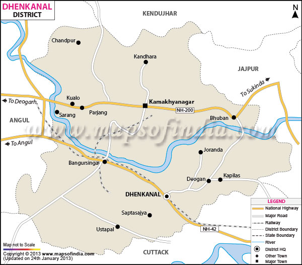
In the very midst of the bustling Odisha lies a land where misty mountains put on memory before vast, emerald green valley outspans. On a careful observation of the Dhenkanal district map it certainly makes a reveal about how it is a geographically talented area that is located between Keonjhar in the north, Cuttack in the south, Jajpur towards the east and Angul to the west. Covering about 4,452 sq. km., this magestic land is indented by the raging-flowing Brahmani river.
The topography of the study area is extremely rugged, with close sal bushes and peaceful riversides visible on the Dhenkanal district map. The Kapilash hill shrine, the world-renowned monastic seat of Mahima Dharma at Joranda and its unique industrial corridor stand out as some of the most remarkable things of this lively region.
History & Culture
Here run terrified riders, triumphant, and revelling messengers from God. Early dynasties, be they the Bhanjas, the Bhauma-Karas or the great Somavamsis, had left their indelible architectural footprints in the soil long before modern roads crisscrossed the region. By the year around 1530 AD, the great king Hari Singh Vidyadhar established Dhenkanal as a royal kingdom which grew to support art, literature and the martial traditions for centuries.
But history here is not the only thing written by kings. It is welded together by martyrs. The brave peasantry of Dhenkanal rose in revolt and resisted the British colonial rule when attempts were made to disarm them and eliminate their sovereignty. The strength of the Prajamandal Movement blazed on these hills. It was a sad night in October 1938 when, on the banks of the Brahmani River at Nilakanthapur, there stood a 12-year-old boat boy named Baji Rout who stood unyielding. When the British forces were armed and ordered to get the boy to row them across, he refused. He lost his life at a young age and paved the way for a revolution that spread across the region, making his name one of the youngest martyrs in the freedom struggle.
Dhenkanal is culturally rich and the rhythmic chants of Mahima Dharma make up its rhythm. Hindu spiritual movement established by Mahima Gosain in the 19th century, this radical, casteless religion does not accept worship of gods or goddesses, worships the formless super being named Alekh. An eternal flame, Akhanda Dhuni, which has been continually burning, is kept by the ascetics dressed in bark in the headquarters of this order, Joranda.
The valleys are all ablaze with the glory of festivals. Thousands of white-robed ascetics congregate in the open during the Joranda Mela, chanted with the moonlight during Magha Purnima, the full moon of the month, and form an amazing spectacle of chant and devotion, as grand is the scenic Laxmi Puja of Dhenkanal town. The whole urban area turns into an open-air art gallery of gates, detailed idols and colorful nights bazaars for eleven days. Not only Gaja Laxmi celebrations but also the Maha Shivaratri, which sees the sacred climb, the district is always in flames with cultural fervour. Click on the dots of culture on the map below and see the presence of spiritual sites and village culture throughout the district of Dhenkanal.
Economy
There is a Dhenkanal district map marked with the rivers and roads which indicate the route of prosperity of this land. The economy is a combination of three segments: agriculture, heavy industrial production and an emerging services sector.
Government Sector
Stable local administration and infrastructure are the foundation for stable communities. Agricultural irrigation projects along the Rengali canal system, as well as irrigation projects along the Brahmani River network, are heavily prioritised by the government. Moreover, the district administration conducts large-scale forestry management initiatives to conserve the forest's timber and non-timber forest products, including Mahua and Kendu leaves which are important livelihood assets for the tribal people in the back-land area.
Public Sector
When one travels along heavy transportation routes on a Dhenkanal district map, one encounters the big, formidable behemoths from industry. The public sector is well established and the joint sector is strong in power generation and heavy metals. Broad-gauge railway lines developed by Indian Railways also carry raw materials such as coal, iron ore and steel to the ports and national markets.
Services Sector
With the growth of heavy industries, a business-oriented services industry sprang up as well. Dhenkanal town is now turned into an educational and commercial hub. The presence of the Indian Institute of Mass Communication Eastern India campus puts the district on the national media education map. Networks of daily commercial activity, such as banking, hospitality for tourists, retail outlets and healthcare infrastructure, add strength to the urban economy.
In addition to these, the area is a metallurgical force due to weighty private investments. Large steel factories, thermal power plants, and manufacturing complexes like GMR Kamalanga Energy, Navabharat Ventures, and Tata Steel at Meramundali function. But under this industry's drumbeat, the seminal drumbeat of the countryside is still the complaining voices of farmers. The alluvial soil here is fertile and has been producing good crops of paddy, sugarcane, pulses and sweet mangos being a major speciality produced in this region.
Tourism
Looking at the Dhenkanal district map, and there is certainly no need to look far for adventure. Study the map and one can see places featuring stone temples, ancient architecture, perched on the summits of the hills, and savouring streams circling verdant wilds.
This 13th century stone marvel is a dedication of Lord Shiva that was built by King Narasimhadeva I of the Ganga dynasty and stands about 457m above the sea level. To reach the shrine, visitors will need to climb 1,352 steps (or walk the ghat road which can be seen in any detailed Dhenkanal district map where they'll be welcomed by the cool breeze of the mountains and vistas of the surrounding area.
Mahima Dharma has Joranda Gadi, its spiritual epicentre. The temple complex is situated approximately 24 kilometres from the headquarters of the District, and consists of three Temple branches, each known by the name: Sunya Mandira, Dhuni Mandira, and Gadi Mandira. There are others: a calm atmosphere, no showy rituals which lend a great spirit of quiet.
Saptasajya is a quiet hill place, amidst a dense Sal forest, which is enveloped in myth. As per the legend, during the Pandavas' exile, they had stayed for some time in these beautiful woods. A stream that's a perennial flows over a smooth rock surface, providing a willed recreational spot and nature getaway.
On the gentle banks of the Brahmani River at Saranga is a grand rock-cut sculpture from the 8th century A.D.Jovial 8th century rock-cut sculpture is located at Saranga, on the peaceful Brahmani River. Here, a giant image of Lord Vishnu making his elila ( play of Ananta snake) is carved into the natural bed of sandstone. Water gently laps around the old stone sculpture, creating a tranquil and serene ambience.
Situated gracefully on the slopes of Paniohala hill in the central part of Dhenkanal town, the Dhenkanal Palace gives a glimpse of the royal history of the area, and has been converted into a good portion of traveller-friendly classical homestay accomodations.
Kualo is an archaeological treasure trove, home to the Kanakeshwar group of temples from the 8th - 9th century A.D., during the rule of the Stambha/Sulki dynasty. Stones and stones of ancient origins now show incredible sculptural artistry, despite suffering a thousand years of weathering.
Demographics
Demographic information is crucial to understanding the social matrix of a region – the people in the space demarcated by one of the Dhenkanal district maps.
According to the 2011 Census the district shows that the population is 1192811. The entire literacy rate is remarkable at 78.76 per cent, of which about 86 per cent are male, while 71 per cent are female, signifying a golden basis for education.
The major language is Odia, which is spoken by the majority of the people with a melodious accent in the region. Urban areas and industrial corridors are generally understood and tribal languages like Mundari and Santhali are spoken in the tribal hill settlements which are shown on the tribal Dhenkanal district map. The district sex ratio is 947 females per 1000 males.
Administration
Efficient governance in a jurisdiction that encompasses rugged hills, a busy industrial economy and a large population demands an effective organizational structure. adminstrative map Dhenkanal is arranged systematically in terms of sub-divisions, tehsils and blocks to map efficient governance and public service delivery.
The administration is headed on the District collector and the Magistrate, assisted by Sub divisional magistrate, Tehsildar and Block development officer. The district has been divided into 3 Sub-Divisions: viz Dhenkanal, Hindol Sub Division and Kamakhyanagar Sub Division. It comprises of 8 tehsils: Dhenkanal, Gondia, Odapada, Hindol, Kamakhyanagar, Bhuban, Parjang and Kankadahhad.
There's 8 community development blocks and 212 gram panchayats supervising development. The administration is equipped with a total of 1,208 villages, inhabited as well as uninhabited. These administrative centers can be found in the Dhenkanal district map and show the extent to which governance is extended from the central urban municipality of Dhenkanal to the distant forest hamlets in Kankadahad.
FAQs
Q.1 What is Dhenkanal's population?
The district population is 1,192,811.
Q.2: How many villages are there?
It has 1,208 villages.
Q.3: What is Dhenkanal famous for?
It is famous for Kapilash Temple and Joranda.
Q.4: Where is the rock-cut Vishnu sculpture?
It is at Saranga.
Q.5: Who was Baji Rout?
He was a 12-year-old local martyr.
Q.6: Which language is spoken here?
Odia is the main language.
Q.7: How many tehsils exist?
There are eight tehsils on a Dhenkanal district map.
