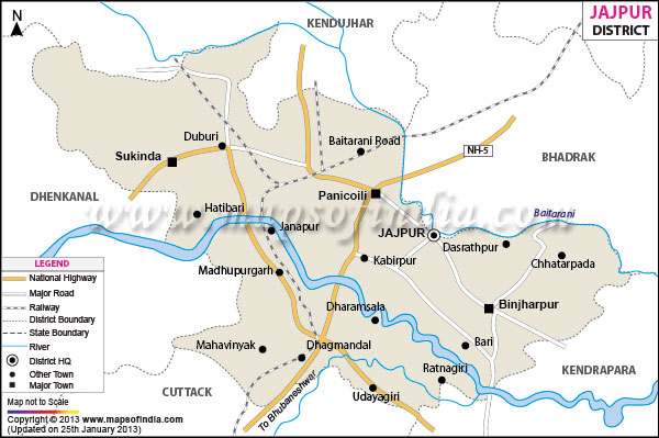
Jajpur, with a total area of 2899 sq km is situated between 20
o.30'- 21
o.10' north latitude and 85
o.40'- 86
o.44' east longitude.
With ten blocks the district has a total population of 1900054 (2001 census). Rich with fertile lands, Jajpur, lying on the banks of river Baitarini, produces a large amount of cash crops every year.
Connected with all major Indian Cities the district also has a fair share of industries.
The Archeological Museum at Ratnagiri, Beleswar Temple and Barahjew Temple are some of the prime appeals of Jajpur district
Jajpur district is spread over an area of 2887.69 Sq. Km. It is situated between 20°.30' - 21°.10' North Latitude and 85°.40' - 86°.44' East Longitude and at an average height of 331 meters from the sea level. The district receives an average rain fall of 1014.5mm. The district is inhabited by 1900054 people.
The district derived its name from the head quarters town of Jajpur. The town was established by "Jajati Keshari", who was the Somabanshi king in early 10th century. The district of Jajpur is surrounded river Baitarini and the districts Keonjhar and Bhadrak in the North., Cuttack district in the south, Dhenkanal in the east and Kendrapara district in the west.
Jajpur is well connected by Road and Rail with the capital city of Bhubaneswar. Jajpur is located 120 kms. away from Bhubaneswar.
The district of Jajpur constitutes of one Revenue sub-division, six Tahalsils namely Dharmasala, Jajpur, Bari, Sukinda, Darpan and Binjharpur ; ten blocks like Sukinda, Jajpur, Dharmasala, Bari, Binjharpur, Badachana, Rasulpur, Korei, Dasarathpur, Danagadi; two Urban Local Bodies like Jajpur and Vysanagar. The district has 1781 villages excluding the 39 villages that fall under the Municipalities and 280 gram panchayat.
The archaeological museum at Ratnagiri is one tourist places of district of Jajpur. The museum has 3400 listed antiquities out of which 220 are displayed in the various galleries. It has four big galleries in which the articles are exhibited. A large number of sculptures, votive stupas, inscribed slabs, terracotta seals, sculpture, sealings, shrines etc. are displayed in the museum.
Last Updated on : February 19, 2026
