







About
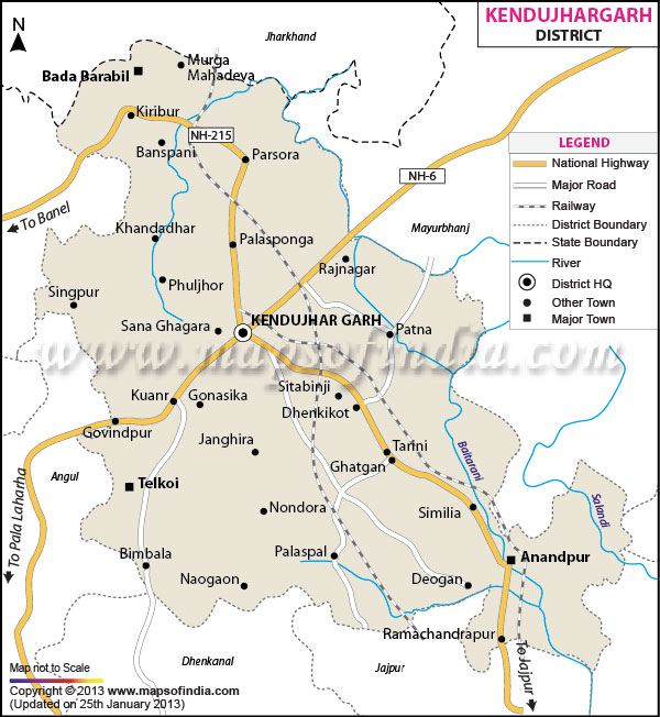
Kendujhar district is one of the most notable administrative landlocked districts in the plains of Odisha, India, also popularly known as Kendujhar district. It covers a large geographical region of about eight thousand three hundred and three square kilometres, having a strategic position in the Northern parts of the State. The district is home to villages that are bounded by the Mayurbhanj district and the Balasore district to the East, Jajpur district to the south, Dhenkanal and Sundargarh districts to the west, and West Singhbhum district of Jharkhand to the north.
A detailed geographical study of the Kendujhar district map reveals all the important mountain ranges, Malyagiri hills and Kanjipani—an important part of the Eastern Ghats to the north of the district. A Kendujhar district map also allows for the identification of key hydrological resources such as the famous river Baitarani, situated within the boundaries of Kendujhar district, originating from the sacred hills in Guptaganga and other tributaries providing water for the local agricultural resources. The geospatial use of the Kendujhar district map provides a general picture of the district in the context of its geospatial importance as an integral geographical zone between the coastal region of Odisha which is rich in mineral resources.
History & Culture
The history of Kendujhar is a multi-layered and intricate one which is rich with the stories of indigenous tribes and royal dynasties. The area was part of the historic kingdom of Kalinga in ancient times and was indirectly influenced by the Mayurbhanj Bhanja dynasty. In the medieval period, Kendujhar had become an independent princely state of the kingdom founded by King Jyoti Bhanja during the first half of the 12th century AD.
Despite the continuation of regionally shifting geopolitical balances in Eastern India over the centuries, the princely state retained its sovereignty. It did well to maintain a delicate balance between diplomacy and the Marathas, and eventually came to a formal treaty with the British East India Company in the early 19th century. An official administrative area visible through the Kendujhar district map reveals how these administrative divisions of the past were the precursor of the present day administrative structures.
In cultural terms, the district is a colourful patch of tribal cultures and traditional culture of classical Odia. More than 44% of the population are indigenous tribesmen (Scheduled Tribes) such as Juang, Bhuyan, Ho, Munda, Santhal, Bathudi, Gond, etc. The slopes of the forest in Kendujhar are considered to be the ancestral land of the Juang tribe, a category of Particularly Vulnerable Tribal Groups. Tribal events such as Karma, Mage Parab, Sarhul, and Sohrai are celebrated with much enthusiasm, including their traditional dances by the community, rhythmic drum beats and worship of nature.
Economy
The economic structure of the district is dynamic in nature and indicates the existence of a balance between primary agricultural activity, heavy mineral processing, industrial manufacture, and public governing activity. The Kendujhar district map under study highlights the fact that the district falls in one of the world's most mineral-rich districts, also referred to as the Barbil-Joda Iron Ore belt.
Administrative services, public administration infrastructure, forest resource management and civil services are important sectors for institutional employment in the government sector. The government conducts huge forestry enterprises, action committees in the district oriented rural development agency, public health departments and an extensive educational network with thousands of civil workers and administrative officers, as shown in any civil Kendujhar district map.
The role of the public sector in initiating industrialisation in the district is very basic. Large public sector mining projects and units are in existence at major levels in the Central and State PSUs here. Huge extraction/processing complexes are operated by enterprises like the National Mineral Development Corporation, Odisha Mining Corporation and the Steel Authority of India Limited. They have created strong physical infrastructure, clearly marked railway lines on a transport Kendujhar district map and have created formal jobs along with community welfare programs on a large scale.
During the past few decades, increased industrial and urban development has fueled the growth of the service sector. Service sectors include commercial banking, retail trade, logistics and freight transport, automotive maintenance, hospitality, healthcare and educational institutions. Heavy vehicle transport logistics is a huge economic ecosystem in areas like Joda, Barbil and Kendujhar town due to the vital role it plays in raw material transportation. Along with this, businesses are doing well in agro-processing, handloom, and eco-tourism hospitality industries, connecting with agro-processing organisations, and selling handicrafts in marketplaces near the main natural reserves.
Although the governance area is heavily industrialised, 80 per cent of the rural population living across Anandapur and Champua plains in the district has agriculture as their sole livelihood. Rice is the most important staple food and is complemented with pulses, oilseeds, vegetables and maize.
Tourism
Kendujhar is a wonderland that remains blessed with beautiful landscapes, ancient heritage sites, sacred temples, waterfalls and so on to this day, with all these attributes making it a tourist delight of Odisha. On a tourist Kendujhar district map, we see that picturesque locations are clustered over the hills of teak forests and in the valleys near the rivers.
The key highlight of the religious tourism of the district is Ghatgaon's sacred Maa Tarini Temple. People come from all over India to get blessings in the holy Shrine every day. The atmosphere at the time of the annual Chaitra Parba festival is suffused with a high level of devotional fervour and therefore Ghatgaon is one of the most visited pilgrimage spots in the State.
The region is simply a beautiful place for nature-loving and ecological visitors, with beautiful waterfalls. Sanaghagara & Badaghagara are twin waterfall sites, situated within a close distance from Kendujhar town. The confluence of Sanaghagara is a scenic narrow waterfall, nestled in the abundant pine tree woods and rocky hills with intact and beautiful landscaped gardens and boating amenities. A couple of meters upstream, along the Machhakandana river, Badaghagara is an impressive, steep and rocky plummet that plunges into a deep, green pool, providing a calm place to stop for picnics or trekking.
Further north, after the mineral-rich belt, is Champua, where you will find the very renowned Murga Mahadev Temple and the waterfall, with the waterfall flowing past the old Mahadev temple dedicated to Lord Shiva. Next, there is the Kanjipani Ghat which is a mountain pass and is always really scenic, with lush ghat roads and obvious panoramic views of misty rolling hills and deep gorges shown on a topography Kendujhar district map.
Demographics
The human population in the district is very rich, with an enormous diversity in terms of tribal populations and rural/urban residents. As per Official Census Population of the district is eighteen lakh one thousand seven hundred and thirty-three (1,801,733). Of these, two out of three or 906,487, are male and 895,246 are female. This results in a very favourable sex ratio, almost 988 females for every 1000 males, which is better than the national average.
The rate of literacy in the district overall is 68.24 per cent. The gender statistics show that male literacy is seventy-eight point one two per cent (78.12) while female's literacy is fifty-eight point two eight per cent (58.28). Compared with the rural interiors of forest land, urban areas are likely to have more education.
From a linguistic point of view, Odia is recognised as the main language and official language of the majority of the people. But in view of the number of tribes and their languages and dialects, they are often used in most parts of the region. The major tribal languages are Ho, Santhali, Mundari and Juang. Other reasons for Hindi and Bengali to be understood and spoken in urban industrial towns such as Barbil and Joda are the presence of industrial workers and traders from the adjoining states.
Administration
The district is administratively divided into three subdivisions: Kendujhar Sadar, Champua, and Anandapur, for administrative convenience, administrative efficiency, peaceful collection of revenue, smooth law and order and security maintenance. With the assistance of the administrative Kendujhar district map, one can easily identify these districts and their working boundaries.
These subdivisions are called as the revenue setup and then subdivided into tehsils. The district comprises 13 tehsils which have been taken as subdivisions for effective management of lands and efficient revenue collection. This district has the administrative tehsils of Kendujhar Sadar, Champua, Ghasipura, Ghatgaon, Harichandanpur, Hatadihi, Jhumpura, Patana, Joda, Saharapada, Anandapur, Telkoi, Banspal and Barbil. Tehsildars are the executive officers of land revenue and the administration and disaster management of the respective tehsil.
The district is also divided into 13 Community Development Blocks for the management of public welfare schemes, construction of rural roads, agricultural extension services, educational programs and such other activities are under these blocks at the rural development level. At lower levels (beyond the block), rural governance is realised through Gram Panchayats. Overall, the district has two thousand one hundred and thirty two (2,132) inhabited and uninhabited revenue villages in its large area of forests and agricultural fields. Refer to the Kendujhar district map to understand an overview of the grouping of these various individual villages into different Gram Panchayats and their relationship with the various urban Municipal centres nearby.
FAQs
Q1: How many villages are in the district?
It contains 2,132 revenue villages.
Q2: What is the total population of the district?
The total population is 1,801,733.
Q3: What is the district famous for?
It is famous for iron ore, Maa Tarini Temple, and waterfalls.
Q4: What are the main waterfalls?
They are Sanaghagara and Badaghagara.
Q5: What is Sitabinji famous for?
It has a fifth-century rock mural called Ravan Chhaya.
Q6: Which river originates here?
The Baitarani River originates in the Guptaganga hills.
Q7: How many tehsils are in the district?
The district has thirteen tehsils.
Last Updated on : May 11, 2026
