







About
The narrative begins in the west of Tamil Nadu, where rivers plough the fertile plains; where markets sway with ceaseless activity; where generations of traders, farmers and artisans have formed a district one of the most economically dynamic regions of South India.
Erode District is situated in Kongu Nadu region of western Tamil Nadu state, which is surrounded by Salem, Namakkal, Karur, Tiruppur and Karnataka state. Erode is the headquarters of the district and is also known as a major commercial center which is notable for textiles, trading of turmeric, etc. and also has markets for agriculture. Larger sections of farmland are fed by enormous streams of the Cauvery River and its tributaries, which have helped to sustain human habitation for centuries.
The district is strategically well positioned, which has helped the district's development. It has been connected to roads and railways, and has become a vital point for transport and trade. The production of textiles, food and other agricultural products, and trade remain the main drivers of production in both the rural and urban sectors.
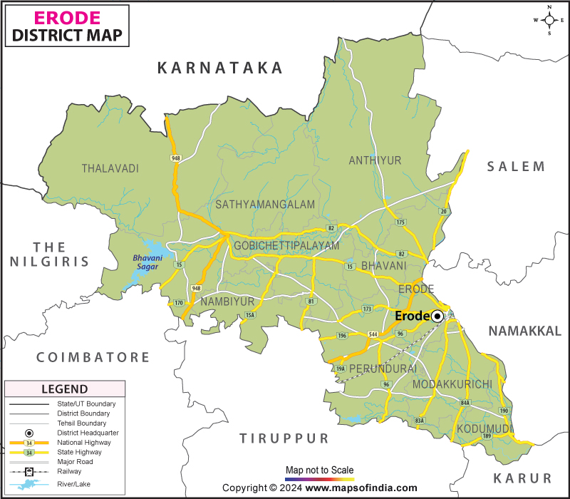
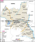
The Erode district map is commonly used by researchers, tourists, students and investors to get knowledge of the huge system of towns, villages, rivers and transport system of the district. The Erode district map shows how geographical factors shape the settlement and economic activities in various areas of the district.
History & Culture
It was the glory days of the areas that are now in the Erode district, in view of the ancient kingdoms. It also encompassed the historical districts of Kongu Nadu, which is an important district in the formation and development of the political and cultural history of the Tamil civilisation.
Over the centuries, the area has been governed by various dynasties, such as the Cheras, Cholas, Pandyas, Hoysalas and Vijayanagaras. Their remains are still visible in the architecture of temples, inscriptions on monuments and in irrigation systems and, even in culture.
Over the centuries, the area was renowned for its farming and commerce. Traders came through with cloth, spices, grain and goods. There were fertile land resources that fostered prosperous settlements, and river systems supported cultivation and commerce.
Erode was an important trading centre and administrative centre during the British colonial period. Investment in the railways and in transport generally improved economic activity, facilitating a closer integration of local markets with wider regional markets.
The cultural traditions in Erode are deep rooted and cherished with the traditions of Kongu Nadu. Folk arts, music, dancing and storytelling are still alive to remember the legacy of the region. Communities celebrate in vibrant, spiritually, traditionally and socially fulfilling festivals.
To date, Pongal is one of the most important festivals, marking the base of the nation's life, agriculture. The grand festivities are held in the Tamil New Year, Aadi Perukku, Navaratri and Deepavali are celebrated in various temples of the district. This enhances the cultural lives of the community with processions, devotional music and community assemblies, fostering a strong sense of community.
Another significant part of this cultural identity is through traditional cuisine. In day-to-day meals, rice-based foods, millet-based foods, and lentil-based foods, along with locally-grown plants, are all a feature. The rich productivity of the area still has an impact on art and cuisine.
In the history and cultural fraternity, an Erode district map could provide a guide to ancient temples, cultural heritage sites and historically significant settlements dotted throughout the district. The Erode district map shows the distribution of cultural sites throughout the urban and rural areas.
The district retains numerous customs and traditions passed down from generation to generation, even today, with its rapid rate of urbanisation. This continuity and change have been a consistent feature of Erode.
Economy
The economic journey of the Erode district is very much like that of a big Industrial presentation. Although the district's economy is built on the foundation of agriculture, textiles, trade, services, and manufacturing bring strong dimensions to the district's economy.
Government Sector
The government sector is important in supporting development in terms of administrative services, public welfare programmes, education, healthcare, irrigation management and infrastructure development. There are a number of programmes and schemes that are managed by district administrators relating to rural development, agriculture and social welfare.
There are some big employment opportunities in sectors such as government schools, local bodies, hospitals, revenue offices and colleges. Expenditures on transportation, water and the development of communities continue to play a positive role in the economy.
Public Sector
The institutions in the public sector can assist in various dimensions of regional development. Cooperatives, electricity distribution companies, transportation companies, and banks are very important to ensure economic stability and improved growth.
Agricultural cooperatives are helping farmers in the procurement, storage and market operations. The public sector banks deliver financial services to allow businesses, entrepreneurs and households to play their part in the economy.
Services Sector
In recent decades, the service sector has grown greatly in importance. Retail trade, logistics, healthcare, education, hospitality industry, financial services and IT-related activities account for significant shares of job and income creation.
Erode city is a prominent trade centre and hub for traders, wholesalers, transport operators and service providers from all over the region. Schools have also become major participants in the local economy.
Agriculture is still one of the major economic activities of the district. The town of Erode has become nationally known for its turmeric cultivation and hence the town is popularly called the “Turmeric City” of India. Paddy, sugarcane, banana, coconut, maize and horticultural crops are also grown by the farmers.
Another strong economic sector is the textile industry. Power looms, weaving units, dyeing units, and textile trading units provide ample jobs. The textile products are sold throughout India and also internationally to different parts of the world, made in the District.
Economic diversity is also bolstered by livestock farming, dairy farms, poultry, food processing, and small industries. The district's transport network is well established to enable the good transport of goods and services.
An Erode district map is commonly used by business analysts to analyse industrial complexes, transport corridors and agricultural areas. The Erode district map will give a good indication of the geographic dimension that allows economic activity to take place across the district.
This gives rise to a resilient, diverse and entrepreneurial economy that continues to shape Erode district's journey and trajectory for sustained economic growth.
Tourism
The tourism in Erode district encompasses a variety of spiritual, natural, historical and recreational experiences. Each location is a unique part of the district's ongoing narrative.
The most popular is the Bhavanisagar dam, constructed over the Bhavani River. This lake is surrounded by aesthetic nature that makes people come to visit this place, such as taking a rest and enjoy beautiful scenery view from the lake.
Bhavani is another prominent pilgrimage site in the district, which houses the Sangameswarar Temple. The temple located at the confluence of rivers such as the Cauvery, Bhavani and Amudha rivers has a high religious significance.
The Kodiveri dam and waterfall across the Bhavani region is a bridge between beauty and engineering heritage. A popular attraction to visit at a place where people come to sit and just enjoy the surroundings and a water course.
There are many old temples in the districts with interesting Dravidian architecture. They preserve centuries' worth of artistic traditions and history.
The Periyar Memorial House in Erode city is a tourist attraction for all who have heard about the social reformer Periyar E.V. Ramasamy.
The Vellode Bird Sanctuary has the region's influence for seasonal bird watching opportunities for both migratory and resident birds. Wetlands and waters provide good habitats for many species of birds.
Demographics
As per the Census of India, 2011, the population of Erode district is around 2.25 million. Since then, the need for increased urban population and economic development is expected to have resulted in population increase.
72.6 per cent of the district's population was literate as per the Census 2011. In general, the educational infrastructure has been continuously strengthened, with the enhancement of literacy and abilities development.
There is a significant reliance on Tamil in the district as the main language of communication and it is the main language of instruction. Other languages (Kannada, Telugu, Urdu) are also spoken by small numbers of people, primarily because of trade, migration and education.
The significant contribution to the district's demographic profile includes the urban centres Erode city, Gobichettipalayam, Bhavani, Sathyamangalam, Perundurai, etc. Rural regions still have a significant agricultural and traditional activities presence.
An Erode district map is used by demographers to study the distribution of population and the location of settlements and urbanisation. The map is useful to visually represent demographic trends where they exist throughout the district of Erode.
The population comprises many different occupational categories, cultural practices and social strata, and it is a vibrant and dynamic society.
Administration
Each district has a District Collector, a government officer who is responsible for governance, development programmes, revenue administration and public services in the respective districts as well.
The different taluks (tehsils) of Erode district are divided into Erode, Perundurai, Gobichettipalayam, Bhavani, Sathyamangalam, Anthiyur, Modakurichi, Kodumudi, Nambiyur and Thalavadi. The district has about 375 revenue villages. These villages serve as the administrative backbone and also the basis of agricultural business in rural areas.
An Erode district map can be used by administrators, planners, and researchers to gauge district boundaries and district development needs. The Erode district map helps authorities in helping them put infrastructure projects and public services in place. In the same way, an Erode district map can be used to assist with planning (such as creating transportation plans, preparing a rural development plan, establishing a resource management plan, etc.). The Erode district map is imperative for work on governance and of immense importance to any work that relates to it.
Erode district can support urban and rural development and serve the inhabitants & communities and deliver services.
FAQs
Q1: What is the total number of villages in Erode district?
Erode district has approximately 375 revenue villages.
Q2: What is the population of the Erode district?
According to the 2011 Census, Erode district had a population of about 2.25 million people.
Q3: What is the Erode district famous for?
Erode district is famous for turmeric production, textile industries, agricultural markets, the Sathyamangalam Tiger Reserve, and its association with social reformer Periyar E.V. Ramasamy.
Last Updated on : July 16, 2026
