







About
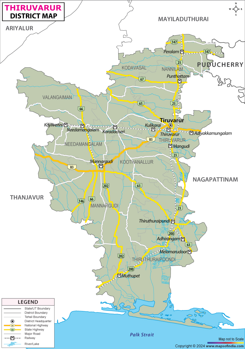
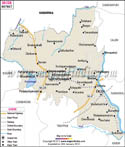
Thiruvarur lies cradled within the thick green stretch of the Cauvery delta, where farming life runs deep alongside long-held beliefs. This place - once called Tiruvarur - breathes history through its soil and temples alike. Known widely as belonging to South India's rice bowl, it unfolds in waves of young paddy, thin rivers splitting off like threads, and rows of tall coconuts swaying together. Water shapes everything, brought by the Cauvery, often honored as mother, flowing into smaller streams that nourish old patterns of growing food. Thiruvarur carries weight in its syllables. Born from Tamil roots - Thiru, a mark of sacredness or blessing - and Aroor, an old regional title noted in 7th-century verses called the Tevaram - it becomes "The Holy Town of Aroor.Up northeast, a sliver connects with Karaikal, part of the Puducherry Union Territory. Through the heart of Thiruvarur town cuts the Odambokki River, splitting the center. Rivers such as Vennar and Vettar curl along the land, feeding nature and villages alike. These waters form quiet veins beneath daily life here. One day after New Year's Eve in 1997, Thiruvarur stepped away from Thanjavur’s larger frame into its own shape. Not quite city, not just village, it hums with rhythms older than memory - yet tractors roll past stone gods at dawn.
History & Culture
History clings to Thiruvarur like salt on old stone. This place rose when mighty empires across southern lands shifted power and shape. One of five sacred centers, it stood at the heart of the great Chola rule - a time when temples soared, and ships crossed wide waters. Words carved deep into the huge Thyagaraja Temple show its weight in royal affairs. Under Kulothunga Chola I, who ruled from 1070 to 1120 CE, the town became central, reshaping devotion around Saivism. Power lived here, etched in worship and law. Stone by stone, the main temple in town grew alongside the land’s changing rulers. Long ago, Aditya Chola I raised its first walls from solid granite during the 800s. Later, under Rajaraja the Great and then Rajendra Chola I, builders reshaped it into something far larger using finely cut rock. When the Chola grip weakened in the 1200s - especially under Rajendra Chola III - the area sparked conflict. Now held like treasure, rival powers fought hard: Madurai’s Pandyas on one side, Karnataka’s Hoysalas on the other.
Thiruvarur kept growing through changing hands - first the Vijayanagar rulers, then the Nayaks of Thanjavur, and later the Marathas. Under Maratha control, something rare happened. The town sheltered the holy statue of Lord Nataraja, which was moved secretly from Chidambaram to keep it safe from attackers. Foreign empires reached this place, too. When French soldiers arrived in 1759 under Count de Lally, they seized the town quickly. They tore apart the Thyagaraja Temple searching for riches that weren’t there. Not just one but all three giants of what we now call Carnatic music came from Thiruvarur. Though separated by time, each lived there at different points in the same century.
Economy
Pounded into shape by fields and furrows, life here turns on farming’s slow grind. Over seventy percent of workers find paychecks rooted in soil, tied one way or another to crops. Shaped by the Cauvery delta’s flow, fortunes rise or fall with planting seasons, especially when rice takes hold. Yet peek beneath that surface and something else appears - three clear supports now holding up what once seemed unchanging.
Government Sector
Most people here work on farms, so state efforts shape daily life in quiet but steady ways. Jobs appear where officials build schools, clinics, or offices across the region. From village classrooms to hospital halls, paychecks often trace back to policy choices made far away. When rains arrive late, farming slows down - so the state pours money into keeping water systems running. Canals stretch far beyond cities, needing constant repair after floods or droughts. Instead of waiting, officials hand out cheaper seeds and nutrients to keep crops growing.
Public Sector
Out there in Thiruvarur, government-backed services shape daily life - especially when it comes to money matters. Branches run by state-owned banks sit alongside local lending groups, spreading widely across towns and villages. These spots hand out farm loans, back crop risks with coverage, while also supporting tiny homegrown businesses with cash boosts. Most farmers turn here first before anywhere else. Small traders do too.
Services Sector
Out here, where towns such as Thiruvarur have been growing, services started rising fast a while back. Pushing it forward? Jobs tied to trade, education, and health care - those kinds show up more now. Around places like Mannargudi, change came through daily needs getting bigger. Then, in spots such as Thiruthuraipoondi, work linked to transport and communication picked up too. Out here, town centers pull in shoppers from hundreds of nearby villages. Because of that flow, stores selling clothes thrive alongside shops full of gold rings and everyday items.
Tourism
Thiruvarur pulls visitors with quiet temples beside wide wetlands. Not just history but living culture shapes what you see walking through its lanes. Old stone carvings stand near bird-filled lakes, creating contrast without effort. Travelers who value stillness might find here something rarely seen elsewhere. Each site feels untouched by rush, shaped more by time than planning. Rooted in tradition yet open to discovery, the land invites slow watching. Temples rise from flat plains while waterways slip quietly. Nature lovers find quiet wonder in Muthupet’s untamed stretch. At the edge of the district, where the Cauvery fan dips into the Palk Strait, sits a green sprawl - around 120 square kilometers wide. Tamil Nadu’s biggest patch of tangled mangroves grows here. The state forest team watches over it, keeping roots and waterways intact. Channels rise and fall with tides, threading through still ponds cloaked in thick greens - mostly Avicennia marina trees. A path made of planks floats above soggy ground, guiding feet deep inside. Birds on long legs arrive each winter; flamingos stand pale pink among herons and pelicans resting low near water edges. Hidden among the quiet mangroves stands Muthupet Dargah, also called Jambavanodai. Seven centuries have passed since its founding, yet it still draws visitors with steady footsteps. Peace fills the air here, thick like morning mist. Though rooted in Islam, those from every belief find space within its walls. Healing is what many hope for when they arrive. Faith shifts quietly under this roof where all are allowed to stay.
Demographics
Deep roots in the land mark life here, where people stay close to family history while building strong communities. Though time passes, old ties hold firm across generations in quiet ways. Official snapshots from 2011 still shape how needs are measured and met today. Numbers tell one part of the story - what grows from them matters just as much. One out of every thousand men here is outnumbered by more than a dozen women. Around 637,584 females live alongside 626,693 males across the area. Taken together, that gives a count of 1,264,277 residents altogether. For each male counted, there are roughly 1,017 females standing even higher than most places nationwide. Most folks in Thiruvarur call small villages home - about 79.61%, which adds up to 1,006,482 souls tucked into quiet countryside spots. Towns and official municipal zones hold just under a fifth of the population, totaling 257,795, marking city-like living as the less common path here. Eight out of ten people in the area can read and write, which beats the country's overall mark near 73%. When split by sex, nearly nine in ten men have basic reading skills. On the women's side, about three-quarters are literate. Most people here speak Tamil first. Nearly everyone - 99.40 percent - uses it at home since birth. A few others talk in Telugu, about 0.25 percent, a trace from older times under the Nayak rule. Some also use Marathi, making up 0.13 percent, left over from when the Marathas were in charge.
Administration
Deep in the countryside, the Thiruvarur district keeps things running through a setup built for reaching remote communities without delay. Running it all is the District Collector, based at an office compound right in the heart of Thiruvarur town. Splitting things up helps keep track of responsibilities. One part handles Thiruvarur, another takes care of Mannargudi. Each area gets its own team for paperwork and legal matters. These teams cover nine separate zones altogether. Names like Tiruthuraipoondi show up here along with others. Nannilam fits into this setup, too. So does Valangaiman. Needing more control led to drawing new lines on maps.
| Official Name | Thiruvarur |
| Location | Tamil Nadu |
| Area | 2,274 sq. km |
| Population | 12,64,277 (2011 census) |
| Language | Tamil,Telugu, Marathi |
FAQs
Q1: What number of villages are there in the district ?
Thiruvarur district holds a number of villages - exactly how many might surprise you. Out of nowhere, Thiruvarur district shapes up as ten Panchayat Unions - also called Blocks - while holding steady at 547 (2011) Revenue Villages, data shows. This snapshot comes straight from recent state records published by the Tamil Nadu government.
Q2: How many people live in the Thiruvarur district altogether?
Thiruvarur district counted 1,264,277 people during India's 2011 census. Males made up 626,693 of that number. Females were slightly more numerous, reaching 637,584. Numbers came straight from official records released after headcounts finished.
Q3: What is the Thiruvarur district famous for?
Home to the grand Sri Thyagarajar Temple, Thiruvarur draws global attention with the country’s biggest temple chariot and a sprawling 25-acre water tank called Kamalalayam. This region stands out because it gave rise to three pillars of Carnatic music - Tyagaraja, Dikshitar, and Syama Sastri. Fertile farmlands stretch across its river-fed plains, earning it deep respect as Tamil Nadu’s primary rice-producing zone.
Last Updated on : July 10, 2026
