







About
All of the great thrillers start with a place that may seem everyday until it's open to its latent powers. The district of Tiruppur is one such district. On a first pass, it appears to be the bustling district in western Tamil Nadu, bound together by roads and rivers and diverse settlements. Fabulous factories buzz with activity day and night; global trade networks grow out of what seem like small, industrial centres; and a story of business enterprise unfolds. Tiruppur is now one of the leading industrial and export hubs in India and is known throughout the world as the “knitwear capital of India”.
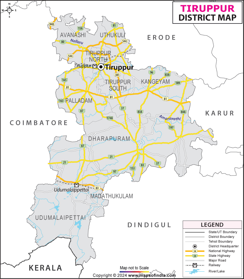
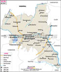
The area of the district is about 5186 km², and it is a mix of industrial development and traditional farm areas. Tiruppur city, the headquarters of the district, is a famous city known as the global hub of Textile manufacturing, which exports garments to various countries. The Tiruppur district map helps identify the economic ecosystem of towns, villages, industrial clusters and agriculture which come into existence.
Tradition and modernity are very much side by side here. Entrepreneurs in the textile business spur innovation, and farmers tend to the fertile lands that have ensured communities for a long time. Educational establishments and industrial parks, and cultural centres play a role in promoting a harmonious development.
The present day Tiruppur is the symbol of determination, adaptability, and economic prosperity. It's a place that can be a source for creating something skillfully crafted and one street can be a part of a larger story of development and change.
History & Culture
From the tales of trade, of endurance, of a culture that has survived through the ages, Tiruppur's history is a long one. In the past, this region was part of the Kongu Nadu region, where agriculture, trade and strong local traditions were very important.
The region has been influenced by several ancient dynasties such as the Cheras, Cholas and Pandyas in the past at various times. Temples, irrigation features and cultural traditions are reminders of their works, which remain to this day. The Tiruppur district map spans an area that experienced centuries of political change, yet had a similar sense of identity regarding the area.
In the medieval period, there were trade routes that connected the region to other areas in South India. The farms brought prosperous settlements and fostered commercial trade. Traders would trade cloth, food, and homemade items with neighbouring regions.
Administrative reforms and an enhancement in economic activities came with the Vijayanagara Empire. Later, the Madurai Nayaks ruled the area and helped in cultural and architectural development. Afterwards, it fell under the sway of Mysore rulers and finally became a part of the British territories.
New commercial opportunities were introduced during Britain's rule. The agriculture of cotton grew and the textile industry slowly gained importance. Such advancements paved the way to the industrial future that would follow for the district. The formation of a road network and trade routes that facilitated economic growth would have been illustrated on the colonial period map of Tiruppur.
Tamil culture is still prevalent in the Tiruppur district. Pongal is a time for the community to celebrate and rejoice in the successful cultivation and a time to feel grateful. Pongal is celebrated with great joy and is a reason for all to unite as a community. There are festivals that enrich the life locally, such as Deepavali, Tamil New Year and temple functions.
The Kongu Tamil culture is of special importance. The traditional cuisine is present, as well as folk songs, customs and agricultural rituals (which still influence daily life). It is still a case of a fairly high degree of cultural continuity in the face of rapid industrialisation.
The temples, like Avinashi Lingeswarar Temple, are historical monuments and evidence of the architectural skill of their eras. There's a profound sense of place through handloom traditions, local arts and community celebrations.
The Tiruppur district map, then, is not merely a geographical representation. This is a representation of a cultural heritage that has evolved over the course of centuries and an economy and social history of adaptation and resilience that continues in the District today.
Economy
The economy of the Tiruppur district is a powerful roller coaster: thundering and unmissable. The district has undergone a remarkable change in itself and is one of the few districts in India that has been as dramatically changed and as successfully. Tiruppur is one of the most flourishing industrial areas of Tamil Nadu and exports textile products abroad.
Government Sector
Government institutions are important in supporting development throughout the district. They create job opportunities, provide public education, health care and welfare services.
Connectivity and quality of life have been enhanced through infrastructure projects, rural development and urban planning initiatives. The Tiruppur district map provides spatial data of the centrally located administrative centres of governance for urban and rural areas, which will be used to support service delivery and governance.
There are government schools, colleges and vocational training centres as part of workforce development. Occupying public health-care facilities reinforces social welfare and drives employment.
Public Sector
Regional development, infrastructure and utilities: Public sector organisations are committed to this. The investment for the transport network, water management systems and energy infrastructure favours the industries and agriculture.
The government initiatives to encourage the development of the industrial estates have brought in businesses and entrepreneurship. The upgrading has improved employment district wide.
Transportation routes, industrial areas, and infrastructure projects connecting the various regions of the district could be featured on the Tiruppur district map.
Services Sector
The district's economy has grown more and more dominated by the services sector. Large numbers are employed in the banking, education, healthcare, logistics and retail trade and hospitality sectors.
Students from all over Tamil Nadu and adjacent states come here for higher education through various colleges. The public health service is still expanding due to the increasing population and industrial activity.
In particular, logistics and transportation services play a special role given that this district has an export-based economy. The easy transportation of goods is vital to Tiruppur's competitiveness. The Tiruppur district map shows that these commercial activities can be made possible by the connectivity (road/rail) of this district.
The textile sector still continues to be the backbone of the economy. Tiruppur is one of the known cities globally for knitwear manufacturing and exports of garments. There are thousands of clothing production units producing clothes for domestic & global markets.
It boosts the economy with its associated industries, such as dyeing, processing, packaging and textile machinery manufacturing. Small and medium enterprises are a special contributor to job creation.
Even in the up and coming industrialization, agriculture remains as important to the success as it was before. Crops like coconut, maize, sugarcane, turmeric, banana and different vegetables are grown on a large scale. The fertile lands seen on the district map of Tiruppur continue to support agricultural productivity and rural people's livelihood.
Tourism
Tourism in Tiruppur district is like a pictorial performance of an adventure story in every sense and depicts the spiritual places, natural beauty, historical gems and so on.
The most renowned place of interest is the Temple of Avinashi Lingeswarar Temple. It is an ancient Lord Shiva temple and a magnificent specimen of Dravidian Architecture. It is visited by pilgrims all year round.
Thirumoorthy Hills is an amazingly beautiful blend of mountains, forests and water bodies. It has a number of visitors owing to its beautiful landscape and the reservoir's peaceful setting. The Tiruppur district map is very useful to guide tourists.
The Thirumoorthy Dam is for both practical and recreational objectives. The beautiful hills surrounding it make it very easy to take in the surrounding sights and photograph them.
Another highlight is the Amaravathi dam. The reservoir is a lovely place to look at and to relax, with the surrounding area also offering these opportunities. The nearby farms for raising crocodiles are also unique and interesting to the visitor.
One of the important centres, which allows easy access to the various natural attractions is Udumalpet. The surrounding land offers fantastic views and landscaped farmland and there are places with a large population of wildlife.
This Tiruppur district map also highlights the facilities for rural tourism to be availed to savor the Kongu culture, traditional food and agriculture activities.
Demographics
Based on the Census of India 2011, the population of Tiruppur district is 2,479,052 (estimates). The district's size has significantly expanded over the last few years, due to industrialisation, urbanisation and employment opportunities.
The literacy rate of the district was around 78.68%, and the educational status of people had considerably improved, and they had access to learning opportunities.
Tamil is the main language in the whole district. Due to the migration, trade and historical interaction, on the other hand, various communities also speak four other languages: Telugu, Kannada, Malayalam and English.
The population in the Tiruppur district is spread out and predominantly resides in industrial hamlets, agricultural hamlets and quickly growing urban areas. The variety of the District's settlement pattern adds to a vibrant economy and culture.
Administration
Tiruppur district can be further divided into nine taluks, namely Tiruppur North, Tiruppur South, Avinashi, Palladam, Dharapuram, Kangeyam, Udumalaipettai, Madathukulam, and Uthukuli.
These taluks support governance, help in revenue administration and delivery of public services. The Tiruppur district map helps administrators in planning infrastructural projects, coordinating resources and developing development projects.
The district has about 270 revenue villages, which are distributed among the taluks in the district. The villages make up the heart of the rural economy, along with retaining many aspects of the traditional Kongu Nadu culture.
Digital governance, data-based planning and integrated development strategies are becoming a current key method of modern administration. The purpose of the Tiruppur district map is to enable decisions on transportation, agricultural, disaster management and urban development.
Ongoing development of the district has led to changes in administrative institutions to meet the needs of a larger population and to maintain efficient governance processes to ensure sustainable development.
The Tiruppur district map is also very important to determine future corridors, industry areas, and infrastructure-specific areas in the district.
FAQs
Q1: What is the total number of villages in Tiruppur district?
Tiruppur district has approximately 270 revenue villages.
Q2: What is the population of Tiruppur district?
According to the 2011 Census, Tiruppur district had a population of approximately 2.48 million people.
Q3: What is Tiruppur district famous for?
Tiruppur district is famous for its knitwear and garment export industry, earning the title of India's knitwear capital.
Last Updated on : July 16, 2026
