







About
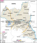
Other districts are noted for their industries. Many are known for their landscapes. But it is the longer-lasting legacy of the Tiruvannamalai district that gets called to mind. History rolls out of the stone walls, the soul moves over an ancient hill in it, and every road opens upward for a story to emerge in this district. A Tiruvannamalai district map makes for an obvious discovery.
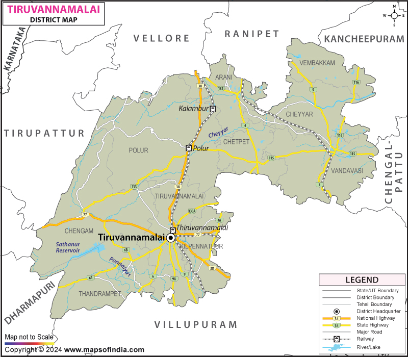
Tiruvannamalai District is in the north-central part of Tamilnadu which is geographically a very strategically located district as there are a few important districts nearby like Vellore, Ranipet, Villupuram, Kallakurichi to the East and south and Krishnagiri & Dharmapuri to the north-west. It is based in the famous temple city Tiruvannamalai having claimed signature architectural style of religious importance. It covers an area of around 6188 km², it has its own geology, agriculture, a forest, streams and an unearthed village settlement. The Tiruvannamalai district map shows the topography that has been formed by nature and a number of centuries of human habitation.
History & Culture
The history of the Tiruvannamalai district goes back to ancient times. This was an area of key settlement, religion and trade long before the modern lines of demarcation were established. Human Settlement dates back many hundreds of years prior, as indicated by archaeological proof. The district has been ruled over time by several strong South Indian dynasties, which have left their marks on it.
The Cholas have made substantial contributions in the field of temple construction, the development of irrigation and administrative organisation. Their successors, the Pandyas and the Hoysalas, had contributed to the cultural significance of the region further. The Vijayanagara period saw the major construction of temples in the region, such as the magnificent Arunachaleswarar Temple. Stone carvings are still present and are evidence of grants, forms of taxation, social habits and patronage from the royalty. The detailed study of the Tiruvannamalai district map would often afford an insight into the historic settlements around water sources, trade routes and religious centres.
History and spirituality go hand-in-hand at the Tiruvannamalai district. Arunachala Hill is considered to be one of the most sacred places of Lord Shiva. It is one of the five sacred Pancha Bhoota Sthalams in Hindu beliefs, known as fire. The belief has become the district's identity for a long time.
The annual Karthigai Deepam festival is one of the most amazing festivals in Tamil Nadu. A big bonfire is lit on the top of Arunachala Hill as darkness settles and can be seen for kilometres around. It seems like the moment in a great movie, and hundreds of thousands of devotees come to watch this special moment. On a monthly basis, the district also gives the opportunity for Girivalam processions by walking around the hill for about fourteen kilometres. The path is well planned, and it is easy to find this path in the Tiruvannamalai district map.
The district has a cultural heritage that transcends religion. The traditional arts of craft activities, classical Carnatic music and Bharatanatyam dances are a part of community life. Spiritualism, too, and the region's past history, have helped to boost Tamil literature. Tiruvannamalai became a renowned meditation and philosophical centre in the world, thanks to the teachings of Ramana Maharshi. Today, thousands of visitors come from dozens of countries to partake in the peacefulness which has drawn the searchers to its shores for over one hundred years.
Economy
This district is quite varied in terms of its geography and its population and has a diverse economy as a result. Many people are working on agriculture-based livelihoods. The agriculture scene is dominated by the paddy, sugarcane, groundnut, millets and pulses, providing the livelihoods for thousands of farming families. Horticulture also plays a significant part in the production of mangoes, coconuts and other fruits. Irrigation tanks and reservoirs, as well as seasonal rivers, are of vital importance to agricultural production. The Tiruvannamalai district map is often referred to by the development authorities in planning irrigation improvements and water management projects.
The Government Sector employs many people in the district. Stable jobs in administrative offices, education, health maintenance and police, but also in revenue services. Investments in rural development, infrastructure and social welfare by the government still support economic growth in the rural and urban sectors.
The Public Sector makes contributions via transportation, banking, power distribution and public infrastructure. State transport links remote villages with towns and commercial centres, enabling the mobility of people and goods. The public sector banks fund agriculture, small business and entrepreneurship programmes.
Over the last couple of decades, there has been great development in the Services Sector. Tourism contributes a significant amount to revenue, with Tiruvannamalai town being a major contributor. Constructed hotels and guest houses, restaurants, travel and retail outlets enjoy a steady stream of pilgrims and tourists. Schools, private hospitals, IT and financial companies have grown too. The Tiruvannamalai district map plays an essential role with increasing importance in the identification of areas suitable for future commercial development.
In addition to this, the district has small-scale industries that contribute to the economy of the district. There are employment opportunities outside the agriculture sector, such as rice mills, textile units, agro-processing units, brick kilns and handicrafts. Rural self-help groups have also enhanced the capacity of the rural population to get involved in economic life, particularly that of women. The benefits of improved infrastructure and wider connectivity are contributing to a broadening of the district's economic base and maintaining its traditional strengths in Tiruvannamalai district.
Tourism
Tiruvannamalai district has a phenomenal variety in tourism. All the cities are different, and it promises a journey that is historical and very personal to you.
The Arunachaleswarar Temple is truly the centre of tourism for this district. An expanse of over twenty five acres, it is a temple complex characterised by soaring gopurams, extensive halls, sacred tanks and elaborate sculptures. It has the eastern entrance of one of India's tallest Rajagopurams. The Tiruvannamalai district map is a common tourist reference for several features found in this holy area.
There is no less important place than Arunachala Hill. The hill is not just a natural landmark, but it is considered to be the manifestation of Lord Shiva himself. The route of the Girivalam is taken by thousands of people each month and poses a special combination of devotion, community and tradition.
The Ashram of Sri Ramana is a popular tourist attraction. The ashram was founded in the name of Ramana Maharshi, and is a place for meditation, study and spiritual reflection. The legacy of another great spiritual leader, Seshadri Swamigal Ashram, goes on in the vicinity. The district is known outside India for the reputation of these institutions.
The district is endowed with various recreational activities and Sathanur Dam is one of them. The dam was built across the Thenpennai River to provide scenic views of the river and its valley, a collection of landscape gardens, boating activities, and a crocodile farm. The area is visited many times a year by interest groups such as families, students and nature lovers. The Tiruvannamalai district map is useful for adventure seekers who venture off the beaten track of this area to explore.
Demographics
According to the Census of India 2011, Tiruvannamalai district had a population of 2,464,875. Their population is dispersed over urban centres, towns and a wide variety of villages which make up the simple social shape of the district.
The literacy rate is about 74.21%, which shows great improvement in gaining access to educational opportunities and boosting literacy awareness. The role of government schools, colleges and private educational institutions for the improvement of literacy and skill development has been significant. Demographic data is often combined with the Tiruvannamalai district map to help to determine what extra infrastructure is needed.
Tamil is the principal language and the main medium of communication all over the district. The district also has a few speakers of Telugu and Urdu. In the socio-cultural aspects, there is a harmonious coexistence of both religious and cultural traditions, and it represents a rich form of social life, which mirrors the rich cultural heritage of Tamil Nadu.
The population includes farmers, traders, government workers, artisans, teachers, entrepreneurs and people working in the service sector. This diversity provides a source for the district to become more resilient and adds to the district's changing economic and cultural mix.
Administration
The district of Tiruvannamalai possesses a firmly established administrative frame beginning with the District Collector. A number of departments manage functions ranging from revenue, agriculture, education & health, public works and social welfare & rural development.
It has seven taluks (tehsils), which are Tiruvannamalai, Arani, Chengam, Cheyyar, Polur, Thandrampet and Vandavasi. These are administrative units which ensure effective governance and ensure that the delivery of government services reached right to its doorsteps of the local community. The Tiruvannamalai district map assists along with helping in planning for roadways, public facilities and emergency response plans.
Local governance is further strengthened with the municipalities and panchayats at the level of villages. The level of the village (panchayats) in local governance is further strengthened. The role played by these institutions in meeting community needs, keeping the infrastructure and undertaking development programmes is crucial.
In Tiruvannamalai district, there are over 860 villages inhabited, located in different areas from the plains to hilly areas. Educational, health care, and transportation facilities are continuing to be enhanced in rural communities. Overall, the Tiruvannamalai district map will remain a valuable administrative tool for mapping and monitoring works of these, as well as balancing regional growth.
FAQs
Q1: How many villages are there in Tiruvannamalai district?
Tiruvannamalai district has more than 860 inhabited villages.
Q2: What is the population of Tiruvannamalai district?
According to the 2011 Census, Tiruvannamalai district has a population of 2,464,875.
Q3: What is the Tiruvannamalai district famous for?
Tiruvannamalai district is famous for Arunachala Hill, the Arunachaleswarar Temple, Karthigai Deepam and Girivalam pilgrimage.
Last Updated on : July 28, 2026
