Thoothukudi (Tuticorin) District Map


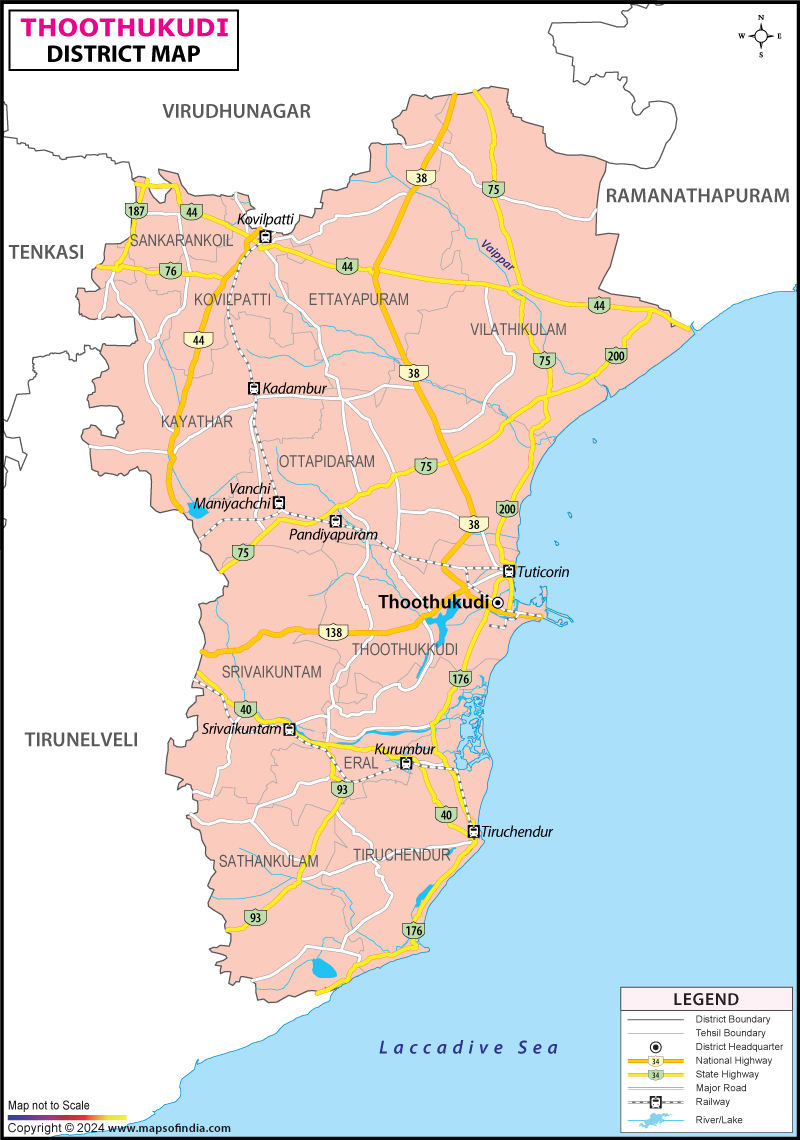
District Map of Thoothukudi (Tuticorin)

separator Click here for Customized Maps arrow custom map
District Map of Thoothukudi (Tuticorin) Virudunagar Ramanathapuram Tirunelveli
Print Email Save Buy Now 
*The Map showing the National Highway, Major roads, other Roads, District Headquarter, Town, etc in the Thoothukudi (Tuticorin) District, Tamil Nadu Disclaimer


  Major Districts of Tamil Nadu  
Kanchipuram District Map Vellore District Map Salem District Map Tirunelveli District Map
Kanchipuram District MapVellore District MapSalem District MapTirunelveli District Map
    
Erode District Map Tiruvallur District Map Thanjavur District Map Viluppuram District Map
Erode District MapTiruvallur District MapThanjavur District MapViluppuram District Map
  other districts of Tamilnadu  >>

Thoothukudi district is located on south east of Tamil Nadu state. The district covers an area of 4,621 sq. km and is bounded by the districts of Tirunelveli on the north, the districts of Virudhunagar and Ramanathapuram, on the east and by Gulf of Mannar on the south-east and by Tirunelveli district on the west and south-west.

Few major industries of Thoothukudi district are SPIC, STERLITE Industries India ltd, TAC, Dharangadhara Chemical Works, Kilburn Chemicals, Madura Coats, Nila Sea Food, Loyal Textiles Ltd. And Transworld Granite Industries

Popular tourist and historical places of Thoothukudi district are:
  • Thoothukudi Tiruchendur
  • Manapad Kalugumalai
  • Ottapidaram Ettayapuram
  • Panchalankurichi Nava Thiruppathi
  • Korkai Athichanallur
  • Vanchi Maniyachi


Last Updated on : 08 February 2012