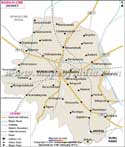
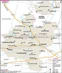
The legendary Chalukya Dynasty once upon a time ruled Bagalkot District, in northern
Karnataka. Occupying a distance of 6593 sq. km Bagalkot District is flanked by Bijapur district in the north and Gadag district in the south.
Raichur district lies towards east of Bagalkot and Koppal district towards southeast along with Belgaum district towards west border the same.
With a net population size of 1,26,100 Bagalkot District with its fertile verdant terrains drained by perennial rivers facilitates extensive cultivation. People also take up animal husbandry, sericulture and are also engaged in factories, industries, banks, agro-industries and other allied services in this fairly urban town.
Bagalkot District is a sightseer's paradise with its panoramic beauty. Tourists can indulge in whirlwind shopping sprees in Aihole, famous for its traditional handloom and silk sarees, and lose themselves in Badami and Pattadakal, a treasure trove of history and culture.