Shimoga District Map


District Map of Shimoga

separator Click here for Customized Maps arrow custom map
District Map of Shimoga Uttara Kannad Haveri Davanagere Chakkamagaluru Udupi
Print Email Save Buy Now 
*District Map of Shimoga highlights national highway, major roads, railways, rivers, etc. Disclaimer


  Major Districts of Karnataka  
Bangalore District Map Belgaum District Map Gulbarga District Map Shimoga District Map
Bangalore District MapBelgaum District MapGulbarga District MapShimoga District Map
    
Tumkur District Map Bijapur District Map Dakshin Kannad District Map Mysore District Map
Tumkur District MapBijapur District MapDakshin Kannad District MapMysore District Map
  other districts of Karnataka  >>

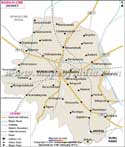
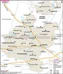
Shimoga, located almost in the central part of Karnataka, occupies an area of 1058,000 Hectares.

It lies between 74o38'-76o4' east latitude and 13o27'-14o39' north longitude.

The total population of Shimoga district as per 1991 census is around 14,52,320.

The industries here are mainly agro based, engineering based and automobile based. Pottery, stone cutting, hand loom works are major ways of sustenance in Shimoga.

Shimoga district is very important as a site for tourism, as the Jog Falls draw a number of people.


Last Updated on : May 17, 2018


-->