






About
Some parts of Bijapur evoke the opening scenes of a large-scale historical adventure — arched domes breaking the skyline, eroding citadels hiding centuries worth of back-room deals and every rock seeming to hold in it a last secret from an empire long gone. Now officially Vijayapura district, it's still better known by its ancient sobriquet, Bijapur, a name that's steeped in immense architectural and historical significance across India and beyond.
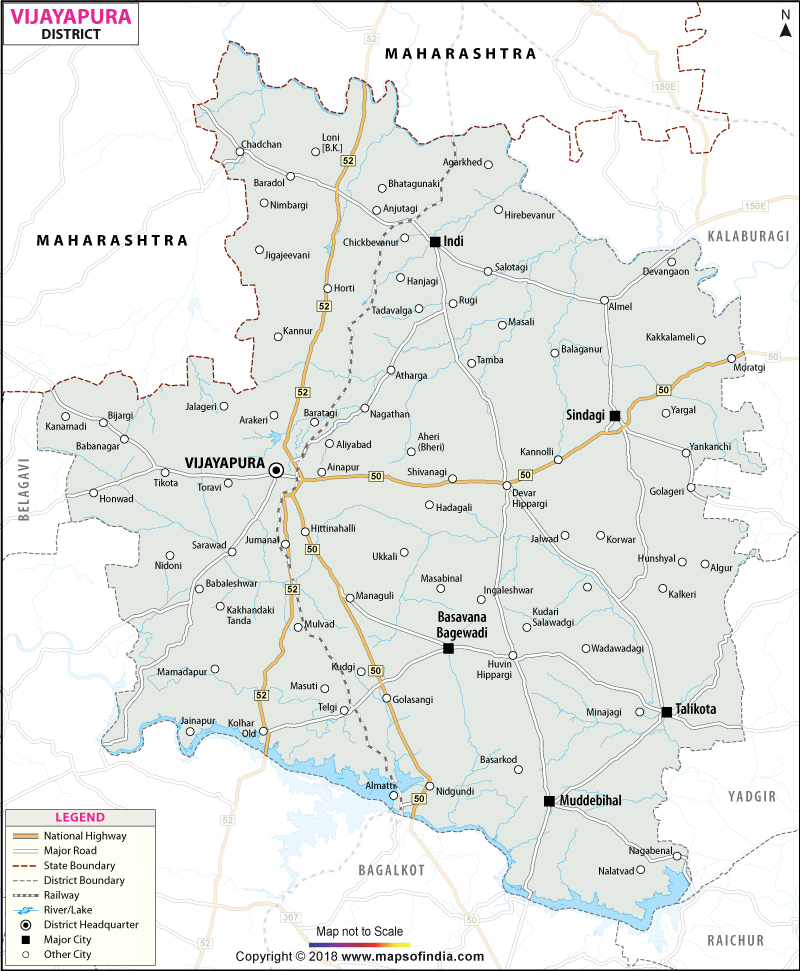
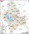
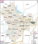
The District is surrounded by some portions of the Karnataka State and Maharashtra State. It has an area of 10,498 Sq.km. and is located in an important area on Deccan Plateau. The map of the district of Bijapur shows a large, extensive area of some broad plains, farm lands, habitation and trade and travel roads connecting kingdoms, traders and travellers since ancient times. Vijayapura city is the district headquarters and a Heritage city of India which is popular.
History & Culture
History is not only seen in Bijapur district but it illuminates itself over the landscape as if it were a character in an epic tale, forever at hand. This region was a part of different South Indian empires such as the Chalukyas, Rashtrakutas and Bahmani Sultanate, well before the dawn of administrative structures as we know them today. However, the most famous episode in the district's history started in the sixteenth century when the Adil Shahi dynasty ascended the throne. This historical distinction is still evident in the Bijapur district map which concentrates on a number of historic sites that used to be the heart of a flourishing kingdom.
The Adil Shahis were patrons of architecture, literature, music and arts. The works of their vision create monuments still fondly remembered centuries later. At this time the area became a point where Central Asian, Persian and native Indian cultures intertwined to create a unique culture in the world.
The Adil Shahi era ended during the conquest of Bijapur in 1686 by Aurangzeb, the Mughal emperor in the capital city of India. But the cultural base laid in that glorious past endured changes of government. Later, admirers of the Nizams of Hyderabad, and subsequently, the modern Indian state, acquired the land, already loaded with precious heritage and tradition. The Bijapur District map is a reminder of these successive layers of history.
The district's culture is highly diverse. Kannada is the main cultural bolst, but there are also significant contributions by Marathi, Urdu and Deccani traditions in this area. A combination of these can be witnessed in language, food, architecture and social tradition.
The festivals join the communities in a colourful event. During Ugadi, the Kannada New Year is celebrated on the day with great enthusiasm. Diyas are lit inside the house and "Nakshatri" lamps are lit in the streets during the Deepavali Festival. The people celebrate both types of Eid with extreme solemnity and largely in unity. It also happens to be a vibrant cultural calendar with events like Basava Jayanti, Moharram festivals, fairs, etc. There are traditions throughout towns and villages that are handed down from generation to generation.
The district's food culture is an integral component of its traditional culture. The traditional sweets, local delicacies, jowar roti and spicy curries are still very much part of everyday life. The traditions of folk music and storytelling are still alive and the spirit of the old ones of these singing events and community gatherings is still alive. From the Bijapur district map, it is visible not only as an administrative district, but as a living museum where history is still strongly present today.
Economy
There is an economy of determination, adaptation and steady growth behind the colossal architecture. Agriculture still provides the backbone of the economy in most of the District. There are large tracts of jowar, bajra, wheat, pulses, sugarcane, sunflower and groundnut along with some oilseeds cultivated over extensive land areas.
The Krishna river basin and irrigation schemes have been significant in ensuring agricultural productivity. Agricultural markets are places of heightened business activity during beneficial seasons, when products are taken from villages to trading centres. The Bijapur district map accentuates the vast rural areas that support this agriculture based economy.
The government sector employs a lot of people. Thousands of people live in the region and work for revenue offices, hospitals, schools, agri-development projects and police forces. Vijayapura is the headquarters of the government which centralises the developmental programmes throughout the district. The Bijapur district map depicts how the administrative centres link the urban and rural communities in terms of governance and public services.
Public sector services also play a vital role in economic development. Private financial institutions, electricity companies, irrigation boards and transport services aid both commerce and private households. Upgrading the infrastructure has connected towns and villages which has stimulated economic growth and market access.
Services have expanded continually over the past few decades. There is a growing number of jobs available in educational institutions, healthcare providers, retail outlets, hospitality and finance related organisations. The district's architectural assets provide immediate economic advantages for businesses serving tourists, ranging from local guides to local businesses and tour operators, and from restaurants to hotels.
In addition to this, economic diversity comes from the small-scale industries. Employment is generated in urban and semi-urban areas due to food processing, manufacturing of construction materials, activities in textiles and agricultural equipment manufacturing. As connectivity and digital infrastructure continue to grow, entrepreneurs are increasingly looking into trade and service opportunities.
Today agriculture is still predominant but the economy in the District is not justifiably dependent upon agriculture. The Bijapur district map shows a system of settlements, markets and administration centres that are interconnected to construct a well-balanced economic framework. In another analysis of the Bijapur district map, the movement of persons and goods between production centres and consumers through the transportation corridors becomes highlighted.
Tourism
It's like a movie to travel in the Bijapur district. Each monument looks as if it's been painstakingly crafted. All the gateways tell their own tales. Each dome is on a mission to dazzle its visitors.
Gol Gumbaz is certainly the attraction here. It was constructed in 1631 when Mohammed Adil Shah was buried there, under the lid of such a large masonry dome, the biggest in the world. However, the Whispering Gallery is the favourite of the museum's visitors: Like all incredible things, a whisper can be heard as far as 40ft away. This is an iconic monument that is attractive to numerous travellers annually since the Bijapur district map routes them here.
The Ibrahim Rauza is one of the most fine examples of Indo-Islamic architecture in India. This is one superbly beautiful building which is delicately carved with symmetry and beautiful Minarets. It has been called by historians an architectural masterpiece of the Deccan. The Bijapur district map includes this monument as one of the very precious monuments of the district.
Another landmark of the architectural superlative of this district is the Jama Masjid. It has a large prayer hall, spectacular arches and, of course, historical interest, which makes it an attraction of both historical and religious interests. In the vicinity is the relatively small but stupendously decorated Mehtar Mahal.
Malik-e-Maidan is a whole new experience. Climbing on a fortification, this is still one of the world's largest war canons, as it is the largest medieval cannon. It leaves us memories of sieges and military campaigns, and royal rivalries. The map of the Bijapur district is particularly interesting in terms of its defensive structures, which were an integral part of the strategic importance of this region.
The fort at Bijapur continues to be a major attraction. The massive walls, the gateways and bastions add to a tale of its power dynamics and imperial ambition. These historical Sites sometimes feel like walking through a historic time land with a view spanning several centuries.
It is a district that is endemic to the historians, architects, culture-loving and photographers. The Bijapur district map ultimately is more than just a compass direction; it's a path through centuries of artistic achievement, political drama and architectural genius.
Demographics
The Census of 2011 indicated the population of Bijapur district as 2177331. The population is spread around areas in towns and cities and also hundreds of villages which help contribute to the social and economic life of the district.
The district's literacy rate is 67.15%. Over the years, the provision of education facilities has grown significantly and this has helped to improve the rates of literacy and human development gradually. The map of the Bijapur district shows how schools, colleges and public institutions are linked to the settlements.
The district is basically Kannada speaking. Urdu, Marathi, Hindi and Lambani are also widely spoken, however. Migration, trade and cultural exchange go back centuries and that explains the linguistic diversity. The Bijapur district map depicts a multi-lingual region with several communities living in the district, having their own culture and identity.
Administration
The administrative infrastructure has improved in Bijapur to ease administration in the comparatively large area of land. Now there are 13 talukas in the district, namely, Vijayapura, Basavana Bagewadi, Indi, Sindagi, Muddebihal, Kolhar, Tikota, Babaleshwar, Nidagundi, Devara Hipparagi, Talikoti, Chadachan and Almel.
At the local administration level these taluks are important units tasked with implementing development programmes, running public services and organising governance. It can be seen from the Bijapur district map that these divisions are used to help in the administration of a geographically extensive area such as a district.
As per Government records in the district of Bijapur, 692 villages are present on the record. These villagers make up the backbone of rural life and agricultural production. The Gram panchayats have a significant role in the functioning of the administration, infrastructure development and providing welfare services to the community.
The road network, health facility, public services centre and educational facilities kept increasing in the district. Consequently, governance has improved and is more accessible. District map, Bijapur is still an important source of input for planning, administrative and other research purposes of the district.
FAQs
Q1: What is the population of Bijapur district?
Bijapur district has a population of 2,177,331.
Q2: How many villages are in Bijapur district?
Bijapur district has 692 villages.
Q3: How many taluks are in Bijapur district?
Bijapur district has 13 taluks.
Q4: What is the literacy rate of Bijapur district?
The literacy rate is 67.15%.
Q5: What is Bijapur district famous for?
It is famous for Gol Gumbaz and Adil Shahi monuments.
Q6: Which is the headquarters of Bijapur district?
Vijayapura is the district headquarters.
Q7: Where is Bijapur district located?
It is located in north-western Karnataka.
Last Updated on : July 31, 2026
