India Nobody covers India as we do
Maps of IndiaTM
India's No.1 Maps Site Since 1998

Google Web www.mapsofindia.com
  Our Channels :  India | Travel | Business | Automobile   
 Newsletter Subscription

Why to Register

e-Mail this Page


Gadag District Map


Gadag District in North Karnataka occupies an area of 4656 sq. km achieved independent existence in the year 1994 after its separation from the parent Dharwad district. Bagalkot Koppal, Bellary, Haveri, Dharwad and Belgaum District form Gadag's geographic boundaries.

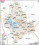
Gadag District has recorded a population of 971,835 as per the 2001 Census. The economy of Gadag is primarily agrarian.

The picturesque Gadag District's magnum opus lies in its epigraphic edifices whose efflorescence is manifested by the architectural landmarks of:

  • Kumara Vyasa's pillars
  • Tontadarya Matha
  • Trikuteshwara Temple
  • Veeranarayana Temple
  • Jumma Masjid and
  • St.Johns Chruch


  • [Buy this map in different sizes or resolutions, please scroll down for the Order Form.]
    Gadag District Map Koppal Bagalkot Belgaum Dharwad Haveri

    For more information contact : solutions@mapsofindia.com

    Disclaimer : All efforts have been made to make this image accurate. However Compare Infobase Limited. and its directors do not own any responsibility for the correctness or authenticity of the same.

    Maps of India CD Ver 6.0

    Maps of India Cd Ver 5.0 For the first time ever -

    • Over 5000 Maps of India without a watermark
    • Driving Direction Maps
    • Hotel Search, Distance Finder
    • 2000 Pages of textual content including hotels and travel information
         Rs 995  (Within India)
         US $ 50 (Outside India)

    IndiaMapStore.com An exclusive online store of maps, atlases, travel guides, and CDs.
    India Maps

    Information on Karnataka |  Profile of Karnataka |  Tourism in Karnataka